Expires:No;;855584
WTPA31 PHFO 022355
TCPCP1
BULLETIN
HURRICANE LESTER INTERMEDIATE ADVISORY NUMBER 37A
NWS CENTRAL PACIFIC HURRICANE CENTER HONOLULU HI EP132016
200 PM HST FRI SEP 02 2016
…LESTER CONTINUING TO MOVE TOWARD THE WEST-NORTHWEST…
SUMMARY OF 200 PM HST…0000 UTC…INFORMATION
———————————————-
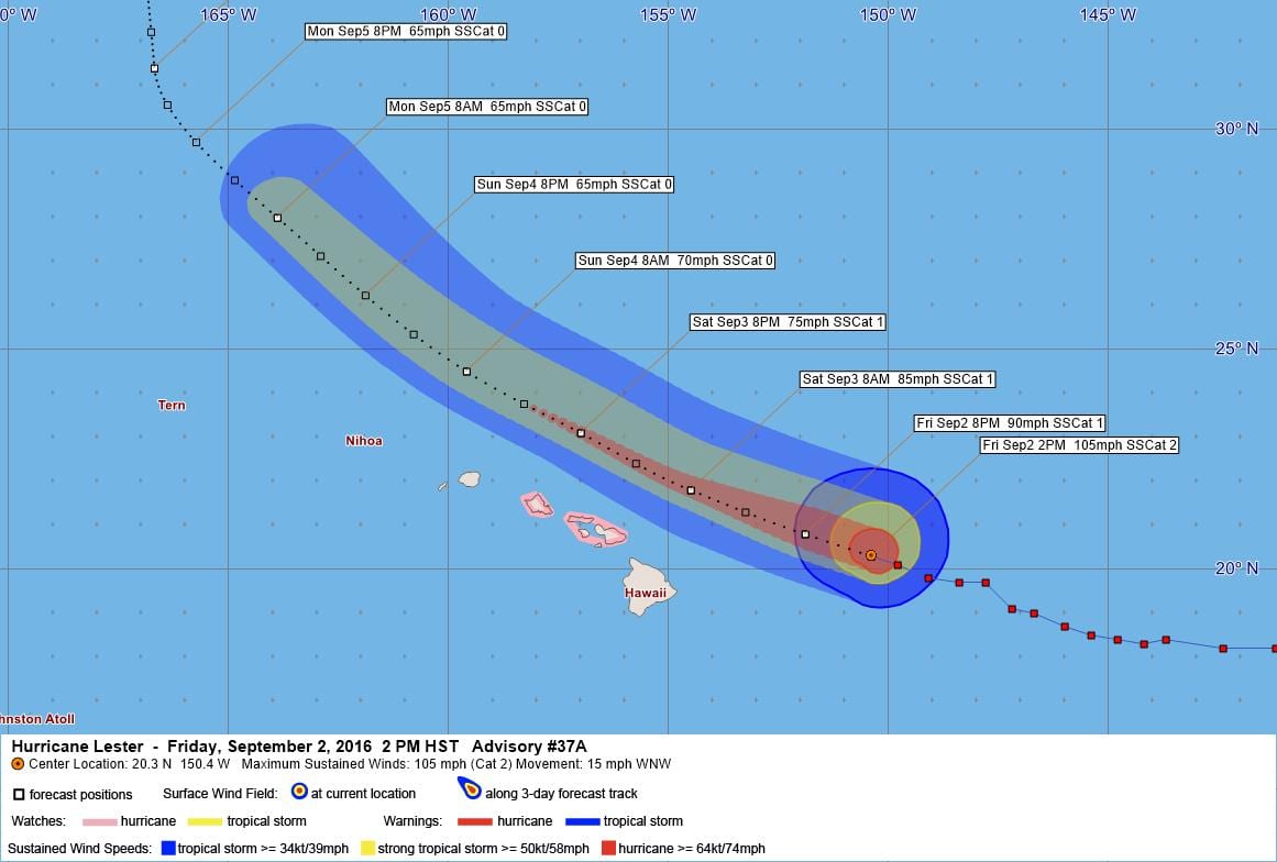
LOCATION…20.3N 150.4W
ABOUT 305 MI…490 KM E OF HILO HAWAII
ABOUT 490 MI…780 KM E OF HONOLULU HAWAII
MAXIMUM SUSTAINED WINDS…105 MPH…165 KM/H
PRESENT MOVEMENT…WNW OR 290 DEGREES AT 15 MPH…24 KM/H
MINIMUM CENTRAL PRESSURE…972 MB…28.71 INCHES
WATCHES AND WARNINGS
——————–
CHANGES WITH THIS ADVISORY:
None.
SUMMARY OF WATCHES AND WARNINGS IN EFFECT:
A Hurricane Watch is in effect for…
* Maui County including the islands of Maui, Molokai, Lanai and
Kahoolawe
* Oahu
A Hurricane Watch means that hurricane conditions are possible
within the watch area. In this case, hurricane conditions are
possible in the next 18 to 36 hours.
Interests elsewhere in the Hawaiian Islands should monitor the
progress of Lester.
For storm information specific to your area, please monitor
products issued by the National Weather Service office in
Honolulu Hawaii.
DISCUSSION AND 48-HOUR OUTLOOK
——————————
At 200 PM HST (0000 UTC), the center of Hurricane Lester was located
near latitude 20.3 North, longitude 150.4 West. Lester is moving
toward the west-northwest near 15 mph (24 km/h). This general motion
is expected to continue through the next 48 hours.
Maximum sustained winds are near 105 mph (165 km/h) with higher
gusts. Gradual weakening is forecast during the next 48 hours.
Hurricane-force winds extend outward up to 45 miles (75 km) from
the center and tropical-storm-force winds extend outward up to 140
miles (220 km).
The estimated minimum central pressure is 972 mb (28.71 inches).
HAZARDS AFFECTING LAND
———————-
WIND: Hurricane conditions are possible over Maui County on
Saturday with tropical storm conditions possible as early as late
tonight. Hurricane conditions are possible over Oahu Saturday
night.
SURF: Large swells generated by Lester will build across Hawaiian
waters tonight and Saturday. Surf generated by these swells will
peak during the weekend across the main Hawaiian Islands, becoming
very large and possibly damaging along exposed shorelines.
RAIN: Heavy rains associated with Lester may impact Maui county
and Oahu Saturday and Sunday.
NEXT ADVISORY
————-
Next complete advisory at 500 PM HST.
$$
Forecaster Wroe
Expires:No;;849574
WTPA41 PHFO 022051
TCDCP1
HURRICANE LESTER DISCUSSION NUMBER 37
NWS CENTRAL PACIFIC HURRICANE CENTER HONOLULU HI EP132016
1100 AM HST FRI SEP 02 2016
The satellite presentation of Lester is slowly degrading as cloud
tops around the eye continue to warm. A U.S. Air Force
Reconnaissance aircraft reported maximum winds of 88 kt from the
SFMR in the northwest quadrant, and Dvorak current intensity
estimates range from 5.0/90 kt from SAB to 5.5/102 kt out of HFO and
JTWC. Given these data, the initial intensity is set at 90 kt. The
U.S. Air Force Reconnaissance aircraft will return to sample Lester
this evening, and the G-V is currently conducting one more synoptic
surveillance mission before heading back to the mainland.
Lester continues to move west-northwestward, and the initial motion
is set at 290/13 kt. The cyclone remains to the south of a low to
mid level ridge and has rounded the upper level ridge axis. Lester
is expected to continue along a general west-northwestward track
through Saturday as it passes near the Hawaiian Islands, followed by
a turn toward the northwest later Sunday and Monday as the system
increasingly feels the effects of an upper level trough to the west.
On Tuesday and Wednesday, Lester is forecast to interact with a deep
North Pacific trough, causing a turn toward the north. The official
track has changed little from the last advisory. During the time
when Lester will be passing near the main Hawaiian Islands, the
forecast remains near the GFEX in the middle of a rather tightly
clustered reliable guidance. Beyond Sunday, the guidance spread
increases, though all show a northward turn.
Lester is expected to gradually weaken through the next five days.
Both CIMSS and SHIPS analyze southerly vertical wind shear affecting
Lester, with the main impact appearing to be a restriction of the
outflow in the southern flank. In addition, Lester is moving over
SSTs of almost 26C, which is more than a degree cooler than this
time yesterday. The combination of these factors has led to the
gradual weakening of Lester. During the next couple of days,
vertical wind shear is expected to hold, if not strengthen slightly,
while SSTs change little. As a result, weakening is forecast to
continue. The intensity forecast closely follows SHIPS and LGEM and
is slightly below IVCN beyond 36 hours.
FORECAST POSITIONS AND MAX WINDS
INIT 02/2100Z 20.1N 149.8W 90 KT 105 MPH
12H 03/0600Z 20.8N 151.9W 80 KT 90 MPH
24H 03/1800Z 21.8N 154.5W 75 KT 85 MPH
36H 04/0600Z 23.1N 157.0W 65 KT 75 MPH
48H 04/1800Z 24.5N 159.6W 60 KT 70 MPH
72H 05/1800Z 28.0N 163.9W 55 KT 65 MPH
96H 06/1800Z 31.4N 166.7W 55 KT 65 MPH
120H 07/1800Z 34.7N 167.0W 50 KT 60 MPH
$$
Forecaster Wroe
Leave a Reply