000
Wtpa33 Phfo 292057
Tcpcp3
Bulletin
Hurricane Ignacio Advisory Number 20
Nws Central Pacific Hurricane Center Honolulu Hi Ep122015
1100 Am Hst Sat Aug 29 2015
…Reconnaissance Aircraft Finds Ignacio A Category Four
Hurricane…
Summary Of 1100 Am Hst…2100 Utc…Information
———————————————–
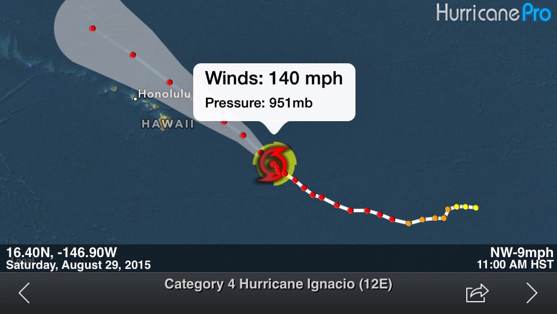
Location…16.4n 146.9w
About 585 Mi…940 Km Ese Of Hilo Hawaii
About 795 Mi…1280 Km Ese Of Honolulu Hawaii
Maximum Sustained Winds…140 Mph…220 Km/H
Present Movement…Nw Or 315 Degrees At 9 Mph…15 Km/H
Minimum Central Pressure…951 Mb…28.08 Inches
Watches And Warnings
——————–
Changes With This Advisory…
None.
Summary Of Watches And Warnings In Effect…
A Tropical Storm Watch Is In Effect For…
* Hawaii County
A Tropical Storm Watch Means That Tropical Storm Conditions Are
Possible Within The Watch Area…Generally Within 48 Hours.
Interests Elsewhere In The Main Hawaiian Islands Should Continue To
Closely Monitor The Progress Of Ignacio. Watches May Be Required
For Additional Islands Later Today Or Tonight.
For Storm Information Specific To Your Area…Please Monitor
Products Issued By The National Weather Service Office In
Honolulu Hawaii.
Discussion And 48-Hour Outlook
——————————
At 1100 Am Hst…2100 Utc…The Eye Of Hurricane Ignacio Was
Located By U.s. Air Force Reserve Reconnaissance Aircraft Near
Latitude 16.4 North…Longitude 146.9 West. Ignacio Is Moving Toward
The Northwest Near 9 Mph…15 Km/H…And This Motion Is Expected To
Continue For The Next Couple Of Days. On The Forecast Track…
Ignacio Will Be Passing Northeast Of The Big Island On Monday.
Maximum Sustained Winds Are Near 140 Mph…220 Km/H…With Higher
Gusts. Ignacio Is A Category Four Hurricane On The Saffir-Simpson
Hurricane Wind Scale. Some Additional Strengthening Is Still
Possible Today Before A Weakening Trend Begins.
Hurricane Force Winds Extend Outward Up To 30 Miles…45 Km…From
The Center…And Tropical Storm Force Winds Extend Outward Up To 140
Miles…220 Km.
The Estimated Minimum Central Pressure Is 951 Mb…28.08 Inches.
Hazards Affecting Land
———————-
Wind…Tropical Storm Conditions Are Possible On The Big Island Of
Hawaii Starting Sunday Night.
Rainfall…Total Rainfall Amounts Of 2 To 4 Inches…With Isolated
Maximum Amounts Near 6 Inches Mainly In Areas Of Higher Terrain…
Are Possible In The Watch Area.
Surf…Large Swells Generated By Ignacio Will Arrive Along East
And Southeast Facing Shores Of The Main Hawaiian Islands Over The
Next Several Days. Resultant Surf Will Be Large And Potentially
Life-Threatening…Especially On The Big Island Later This Weekend
And Early Next Week.
Next Advisory
————-
Next Intermediate Advisory…200 Pm Hst.
Next Complete Advisory…500 Pm Hst.
$$
Forecaster R Ballard
Discussion


Leave a Reply