Bulletin
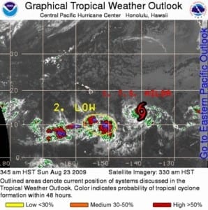
000 Wtpz31 Knhc 231450 Tcpep1 Bulletin Tropical Storm Hilda Advisory Number 5 Nws Tpc/national Hurricane Center Miami Fl Ep112009 800 Am Pdt Sun Aug 23 2009
…hilda Entering The Central Pacific Basin…
At 800 Am Pdt…1500 Utc…the Center Of Tropical Storm Hilda Was Located Near Latitude 13.8 North…longitude 140.1 West Or About 2075 Miles…3335 Km…west-southwest Of The Southern Tip Of Baja California And About 1070 Miles…1725 Km…east-southeast Of Hilo Hawaii.
Hilda Is Moving Toward The West Near 9 Mph…15 Km/hr…and This Motion Is Expected To Continue For The Next Couple Of Days.
Maximum Sustained Winds Are Near 45 Mph…75 Km/hr…with Higher Gusts. Slow Strengthening Is Forecast During The Next 48 Hours.
Tropical Storm Force Winds Extend Outward Up To 45 Miles…75 Km From The Center.
Estimated Minimum Central Pressure Is 1003 Mb…29.62 Inches.
…summary Of 800 Am Pdt Information… Location…13.8n 140.1w Maximum Sustained Winds…45 Mph Present Movement…west Or 275 Degrees At 9 Mph Minimum Central Pressure…1003 Mb
This Is The Last Public Advisory Issued By The National Hurricane Center On Hilda. Future Advisories Will Be Issued By The Central Pacific Hurricane Center Under Awips Header Tcpcp5 And Wmo Header Wtpa35 Phfo…beginning At 1100 Am Hst.
$$ Forecaster Kimberlain/pasch







Leave a Reply