997
WTPA31 PHFO 080239
TCPCP1
BULLETIN
Hurricane Hector Advisory Number 31
NWS Central Pacific Hurricane Center Honolulu HI EP102018
500 PM HST Tue Aug 07 2018
…POWERFUL HURRICANE HECTOR CONTINUING TO MOVE WESTWARD…
…FAR NORTHERN FRINGES OF THE HURRICANE WILL BRUSH THE BIG ISLAND
ON WEDNESDAY…
SUMMARY OF 500 PM HST…0300 UTC…INFORMATION
———————————————-
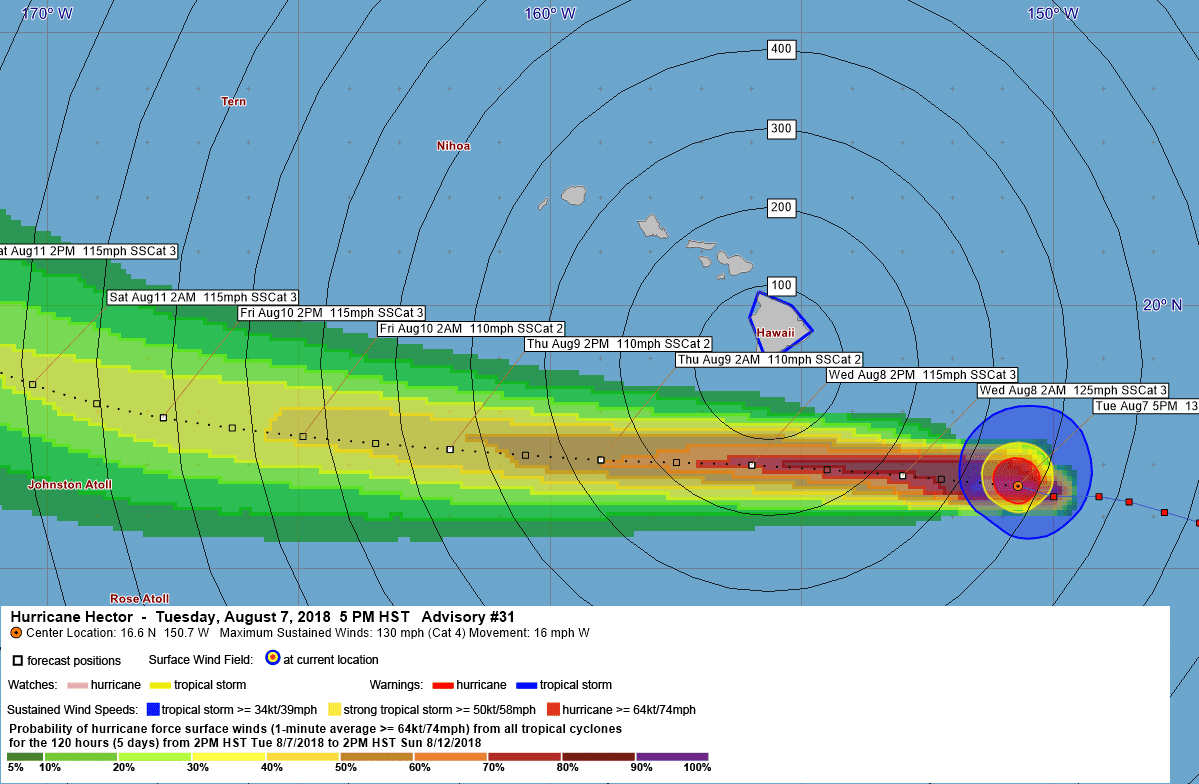
LOCATION…16.6N 150.7W
ABOUT 370 MI…590 KM ESE OF SOUTH POINT HAWAII
ABOUT 570 MI…920 KM ESE OF HONOLULU HAWAII
MAXIMUM SUSTAINED WINDS…130 MPH…215 KM/H
PRESENT MOVEMENT…W OR 280 DEGREES AT 16 MPH…26 KM/H
MINIMUM CENTRAL PRESSURE…952 MB…28.12 INCHES
WATCHES AND WARNINGS
——————–
CHANGES WITH THIS ADVISORY:
A Tropical Storm Warning has been issued for Hawaii County.
SUMMARY OF WATCHES AND WARNINGS IN EFFECT:
A Tropical Storm Warning is in effect for…
* Hawaii County
A Tropical Storm Warning means that tropical storm conditions are
expected somewhere within the warning area.
Interests on Johnston Island should monitor the progress of Hector.
For storm information specific to your area, please monitor
products issued by the National Weather Service office in
Honolulu Hawaii.
DISCUSSION AND OUTLOOK
———————-
At 500 PM HST (0300 UTC), the center of Hurricane Hector was located
near latitude 16.6 North, longitude 150.7 West. Hector is moving
toward the west near 16 mph (26 km/h) and this general motion is
expected to continue through the next couple of days. On the
forecast track, the center of Hector will pass 100 to 150 miles
south of the Big Island during the day on Wednesday. Remember, the
effects of a hurricane are far reaching and can extend well away
from the center.
Maximum sustained winds are near 130 mph (215 km/h) with higher
gusts. Hector is a category 4 hurricane on the Saffir-Simpson
Hurricane Wind Scale. Some weakening is forecast during the next 48
hours.
Hurricane-force winds extend outward up to 40 miles (65 km) from the
center and tropical-storm-force winds extend outward up to 115 miles
(185 km).
The estimated minimum central pressure is 952 mb (28.12 inches).
HAZARDS AFFECTING LAND
———————-
SURF: Swells generated by Hector are expected to reach southeast
and east facing shores of the Big Island and eastern Maui late
today, likely becoming large and dangerous by late tonight and
Wednesday.
WIND: Tropical storm conditions are expected across portions of
the Big Island on Wednesday as the core of Hector passes to the
south. The strongest winds are expected downslope from mountains,
across elevated terrain, over headlands, and through gaps.
NEXT ADVISORY
————-
Next intermediate advisory at 800 PM HST.
Next complete advisory at 1100 PM HST.
$$
Forecaster R Ballard
059
WTPA41 PHFO 080302
TCDCP1
Hurricane Hector Discussion Number 31
NWS Central Pacific Hurricane Center Honolulu HI EP102018
500 PM HST Tue Aug 07 2018
The last reconnaissance pass through Hector showed maximum flight
level winds of 124 kt in the northern eyewall, as well as
believable SFMR winds of 111 kt. This is the justification for
maintaining Hector at 115 kt as of this advisory. Over the last few
hours, the eye temperatures on IR imagery have been cooling, which
may signal the beginning of the anticipated weakening trend.
The longer term motion remains 280/14, though there are perhaps
some signs of a more due westward motion over the past few hours.
The track philosophy has not changed, though Hector’s persistent
slow trek toward higher latitudes now will bring the tropical storm
force wind field associated with the hurricane close enough to the
Big Island to necessitate issuing a tropical storm warning. The
forecast track has been adjusted slightly to the north during the
next 48 hours, but still lies very close to the guidance consensus.
After 48 hours, Hector is expected to begin gradually gaining
latitude as it passes by the anticyclone and comes under increasing
influence of an upper trough to the west of 170W.
Hector is in a low shear environment, but only marginally warm sea
surface temperatures. This is expected to yield a gradual weakening
trend for the next couple of days. Afterward, the low-shear
environment continues, but water temperatures gradually warm, which
may allow Hector to restrengthen a bit. Toward the end of the
forecast period, wind shear may start to affect the hurricane, and
the official forecast initiates a new weakening trend. The overall
confidence in the intensity forecast is somewhat low due to these
competing factors. As before, our intensity forecast tends to more
closely follow the ICON guidance, which shows Hector remaining
stronger than SHIPS guidance indicates.
FORECAST POSITIONS AND MAX WINDS
INIT 08/0300Z 16.6N 150.7W 115 KT 130 MPH
12H 08/1200Z 16.8N 153.0W 110 KT 125 MPH
24H 09/0000Z 17.0N 156.0W 100 KT 115 MPH
36H 09/1200Z 17.1N 159.0W 95 KT 110 MPH
48H 10/0000Z 17.3N 162.0W 95 KT 110 MPH
72H 11/0000Z 17.9N 167.7W 100 KT 115 MPH
96H 12/0000Z 19.5N 172.7W 100 KT 115 MPH
120H 13/0000Z 21.7N 177.3W 95 KT 110 MPH
$$
Forecaster R Ballard


Leave a Reply