Expires:No;;884315
WTPA31 PHFO 031453
TCPCP1
BULLETIN
HURRICANE LESTER ADVISORY NUMBER 40
NWS CENTRAL PACIFIC HURRICANE CENTER HONOLULU HI EP132016
500 AM HST SAT SEP 03 2016
…THE HURRICANE WATCH HAS BEEN CANCELLED FOR ALL ISLANDS IN
THE STATE OF HAWAII…
…DANGEROUS SURF IS STILL EXPECTED ACROSS THE HAWAIIAN ISLANDS
THIS WEEKEND…
SUMMARY OF 500 AM HST…1500 UTC…INFORMATION
———————————————-
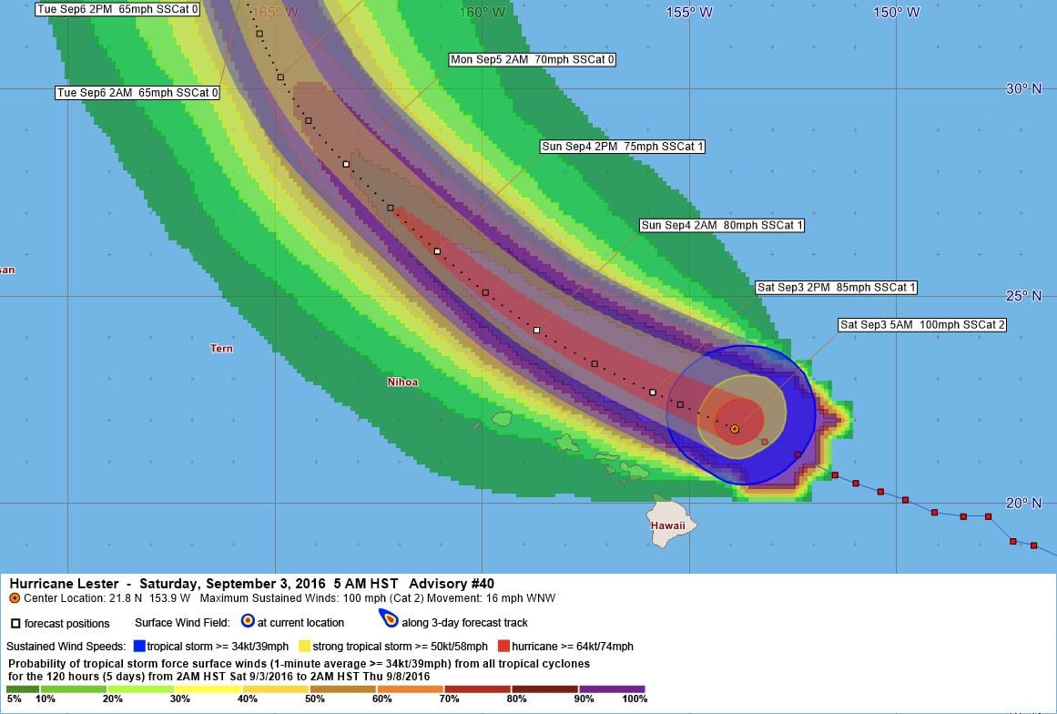
LOCATION…21.8N 153.9W
ABOUT 165 MI…265 KM NNE OF HILO HAWAII
ABOUT 260 MI…415 KM E OF HONOLULU HAWAII
MAXIMUM SUSTAINED WINDS…100 MPH…155 KM/H
PRESENT MOVEMENT…WNW OR 295 DEGREES AT 16 MPH…26 KM/H
MINIMUM CENTRAL PRESSURE…982 MB…29.00 INCHES
WATCHES AND WARNINGS
——————–
CHANGES WITH THIS ADVISORY:
The Hurricane Watch for Maui County and Oahu has been cancelled.
SUMMARY OF WATCHES AND WARNINGS IN EFFECT:
There are no coastal watches or warnings in effect.
Interests in the Hawaiian Islands should continue to monitor the
progress of Lester.
DISCUSSION AND 48-HOUR OUTLOOK
——————————
At 500 AM HST (1500 UTC), the center of Hurricane Lester was located
near latitude 21.8 North, longitude 153.9 West. Lester is moving
toward the west-northwest near 16 mph (26 km/h). This general
motion is expected to continue through tonight, with a turn toward
the northwest expected on Sunday.
Maximum sustained winds are near 100 mph (155 km/h) with higher
gusts. Gradual weakening is forecast during the next 48 hours.
Hurricane-force winds extend outward up to 60 miles (95 km) from the
center and tropical-storm-force winds extend outward up to 150 miles
(240 km).
The estimated minimum central pressure is 982 mb (29.00 inches).
HAZARDS AFFECTING LAND
———————-
SURF: Swells generated by Lester will cause large and dangerous surf
across exposed shorelines of the Hawaiian Islands this weekend.
RAIN: Locally heavy showers or thunderstorms are possible this
weekend as Lester passes north of the Hawaiian Islands.
NEXT ADVISORY
————-
Next intermediate advisory at 800 AM HST.
Next complete advisory at 1100 AM HST.
$$
Forecaster Jelsema/R Ballard
Expires:No;;884331
WTPA41 PHFO 031456
TCDCP1
HURRICANE LESTER DISCUSSION NUMBER 40
NWS CENTRAL PACIFIC HURRICANE CENTER HONOLULU HI EP132016
500 AM HST SAT SEP 03 2016
Lester is becoming increasingly influenced by southwesterly
vertical wind shear as evident in satellite animations, making the
low level circulation center (LLCC) difficult to find. Thankfully,
the U.S. Air Force reconnaissance aircraft sampled the system
through much of the night, and was very helpful in finding the LLCC
of Lester. The hurricane hunters found multiple areas with SFMR
winds of 80+ knots when flying the system. Additionally, a 96 knot
flight level wind which reduces to 86 knots at the surface was
found at 03/0925Z. Therefore the initial intensity will be set at 85
knots for the 15Z advisory. This agrees well with a blend of the
Dvorak classifications from PHFO, SAB and JTWC, which ranged from
4.5/77 knots to 5.0/90 knots. Another reconnaissance aircraft is
scheduled to investigate the storm later this morning.
The initial motion is toward the west-northwest at 14 knots. This
motion is expected to continue today as Lester continues to be
steered by a deep layered ridging to the north of the system and
an upper level trough near 160W. Lester will begin to round the
southwestern periphery of the deep layered ridge tonight, while an
upper level trough approaches Midway Atoll. As a result, Lester
should change course to a more northwesterly track through 72 hours,
then move toward the north and northeast through 120 hours in
between the deep layered ridge to the east and the upper trough
moving in from the west. The official CPHC track is very close to
the previous advisory through 72 hours, with an increase in forward
speed to more closely match the latest model guidance beyond 72
hours.
Lester is expected to gradually weaken over the next couple days
due to strong southwesterly vertical wind shear as it moves over
marginal 26 to 27C sea surface temperatures (SSTs). The official
intensity forecast is nearly a duplicate of the previous advisory,
and is closely aligned with the latest SHIPS and IVCN guidance. The
forecast calls for Lester to weaken into a tropical storm on Sunday
or Sunday night, with an extratropical transition expected early
next week as Lester becomes absorbed into a large mid-latitude
trough and moves over increasingly unfavorable SSTs.
The Hurricane Watch has been cancelled for all of the Hawaiian
Islands as Lester continues to closely follow a tightly clustered
suite of model guidance, just to the north of the state. Despite
the expectation that hurricane or tropical storm conditions will
remain just north of the Islands, large and dangerous surf is
expected through the weekend. Refer to the latest coastal hazard
message (CFWHFO) from the National Weather Service in Honolulu, HI
for additional information.
FORECAST POSITIONS AND MAX WINDS
INIT 03/1500Z 21.8N 153.9W 85 KT 100 MPH
12H 04/0000Z 22.7N 155.9W 75 KT 85 MPH
24H 04/1200Z 24.2N 158.7W 70 KT 80 MPH
36H 05/0000Z 26.1N 161.1W 65 KT 75 MPH
48H 05/1200Z 28.2N 163.3W 60 KT 70 MPH
72H 06/1200Z 32.4N 165.8W 55 KT 65 MPH
96H 07/1200Z 37.0N 165.0W 55 KT 65 MPH
120H 08/1200Z 43.5N 159.5W 45 KT 50 MPH
$$
Forecaster Jelsema/R Ballard


Leave a Reply