000
WTPZ35 KNHC 240242
TCPEP5
BULLETIN
HURRICANE PATRICIA ADVISORY NUMBER 17
NWS NATIONAL HURRICANE CENTER MIAMI FL EP202015
1000 PM CDT FRI OCT 23 2015
…PATRICIA WEAKENING BUT REMAINS AN EXTREMELY DANGEROUS
MAJOR HURRICANE OVER SOUTHWESTERN MEXICO…
SUMMARY OF 1000 PM CDT…0300 UTC…INFORMATION
———————————————–
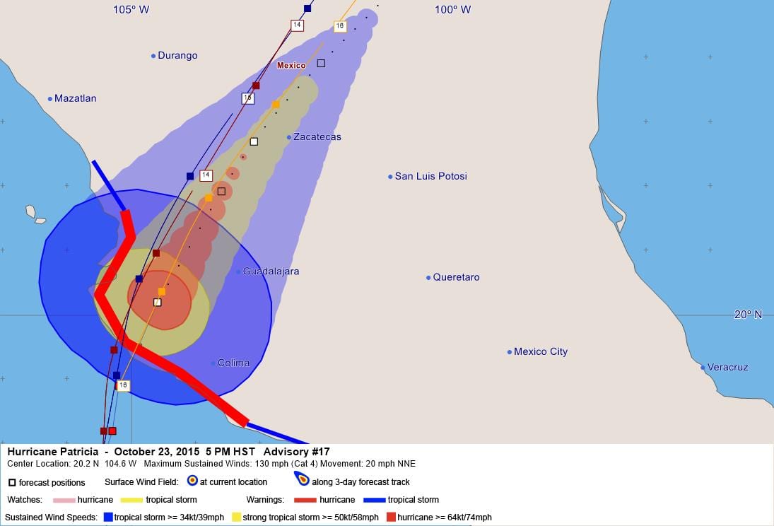
LOCATION…20.2N 104.6W
ABOUT 85 MI…135 KM NNW OF MANZANILLO MEXICO
ABOUT 50 MI…75 KM SE OF PUERTO VALLARTA MEXICO
MAXIMUM SUSTAINED WINDS…130 MPH…215 KM/H
PRESENT MOVEMENT…NNE OR 20 DEGREES AT 20 MPH…31 KM/H
MINIMUM CENTRAL PRESSURE…946 MB…27.94 INCHES
WATCHES AND WARNINGS
——————–
CHANGES WITH THIS ADVISORY:
The government of Mexico has discontinued the Hurricane Watch for
Mexico from east of Punta San Telmo to Lazaro Cardenas.
SUMMARY OF WATCHES AND WARNINGS IN EFFECT:
A Hurricane Warning is in effect for…
* San Blas to Punta San Telmo
A Tropical Storm Warning is in effect for…
* East of Punta San Telmo to Lazaro Cardenas
* North of San Blas to El Roblito
A Hurricane Warning means that hurricane conditions are expected
somewhere within the warning area.
A Tropical Storm Warning means that tropical storm conditions are
expected somewhere within the warning area.
For storm information specific to your area, please monitor
products issued by your national meteorological service.
DISCUSSION AND 48-HOUR OUTLOOK
——————————
At 1000 PM CDT (0300 UTC), the center of Hurricane Patricia was
located near latitude 20.2 North, longitude 104.6 West. Patricia is
moving toward the north-northeast near 20 mph (31 km/h). Patricia
should continue to move farther inland over southwestern Mexico, and
move quickly north-northeastward across western and northern Mexico
through Saturday.
Maximum sustained winds have decreased to near 130 mph (215 km/h)
with higher gusts. Patricia is a category 4 hurricane on the
Saffir-Simpson Hurricane Wind Scale. Rapid weakening is forecast,
with Patricia expected to become a tropical storm tomorrow morning,
and a tropical depression tomorrow afternoon.
Hurricane-force winds extend outward up to 35 miles (55 km) from the
center and tropical-storm-force winds extend outward up to 140 miles
(220 km).
The estimated minimum central pressure is 946 mb (27.94 inches).
HAZARDS AFFECTING LAND
———————-
WIND: Hurricane conditions are occurring across the hurricane
warning area. Tropical storm conditions are expected to continue
across portions of the warning area and in inland areas near the
center through early Saturday.
RAINFALL: Patricia is expected to produce total rainfall
accumulations of 8 to 12 inches, with isolated maximum amounts of
20 inches, over the Mexican states of Nayarit, Jalisco, Colima,
Michoacan, and Guerrero through Saturday. These rains are likely
to produce life-threatening flash floods and mudslides.
STORM SURGE: Water levels are expected to gradually subside
overnight but remain above normal through late Saturday. Near the
coast, large and destructive waves are forecast to continue
overnight.
SURF: Swells generated by Patricia are likely to affect the
southwest coast of Mexico for the next day or so. These swells are
likely to cause life-threatening surf and rip current conditions.
Please consult products from your local weather office.
NEXT ADVISORY
————-
Next intermediate advisory at 100 AM CDT.
Next complete advisory at 400 AM CDT.
$$
Forecaster Blake/Stewart
WTPZ45 KNHC 240244
TCDEP5
HURRICANE PATRICIA DISCUSSION NUMBER 17
NWS NATIONAL HURRICANE CENTER MIAMI FL EP202015
1000 PM CDT FRI OCT 23 2015
Satellite and surface data indicate that the center of Patricia made
landfall at about 615 PM CDT (2315 UTC) near Cuixmala, Mexico with
maximum sustained winds estimated at 145 kt/165 mph. Since that
time, the eye has become obscured, with a large circular area of
deep convection continuing near the center. The initial wind speed
is reduced to 115 kt in agreement with the TAFB Dvorak
classification. Rapid weakening should continue as the cyclone
interacts with the mountains of Mexico. The forecast intensity is
largely based on the Decay-SHIPS model, but is a little lower than
that model due to the very high terrain. Patricia should move to
the north-northeast and northeast ahead of a mid-level trough over
the south-central United States until it dissipates in a day or so.
The global models continue to depict the development of a cyclone
near the Texas coast over the weekend and this system should be
non-tropical in nature. However, this cyclone is expected to draw
significant amounts of moisture from Patricia’s remnants, and could
result in locally heavy rainfall over portions of the northwestern
Gulf of Mexico coastal area within the next few days. Refer to
statements from local National Weather Service forecast offices for
details.
An unconfirmed sustained wind report of 185 mph and a gust to 211
mph was received from a NOAA/NWS Hydrometeorological Automated Data
System (HADS) elevated station (295 ft) at Chamela-Cuixmala, Mexico
near the time of landfall. This observation should be considered
unofficial until it has been quality controlled.
KEY MESSAGES:
1. Now that Patricia has moved inland, while the coastal threat is
decreasing, strong and damaging winds, especially at higher
elevations, will persist through Saturday morning.
2. Very heavy rainfall is likely to cause life-threatening flash
floods and mudslides in the Mexican states of Nayarit, Jalisco,
Colima, Michoacan and Guerrero through Saturday.
FORECAST POSITIONS AND MAX WINDS
INIT 24/0300Z 20.2N 104.6W 115 KT 130 MPH…INLAND
12H 24/1200Z 22.7N 103.1W 60 KT 70 MPH…INLAND
24H 25/0000Z 25.0N 101.0W 30 KT 35 MPH…POST-TROP/INLAND
36H 25/1200Z…DISSIPATED
$$
Forecaster Blake/Stewart


Leave a Reply