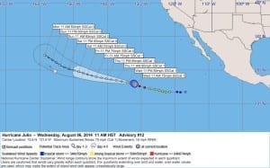
Julio Number 12 Public Advisory and Discussion
WTPZ35 KNHC 062046
TCPEP5
BULLETIN
HURRICANE JULIO ADVISORY NUMBER 12
NWS NATIONAL HURRICANE CENTER MIAMI FL EP102014
200 PM PDT WED AUG 06 2014
…JULIO CONTINUING WEST-NORTHWESTWARD…
SUMMARY OF 200 PM PDT…2100 UTC…INFORMATION
———————————————-
LOCATION…15.8N 131.8W
ABOUT 1555 MI…2500 KM E OF HILO HAWAII
MAXIMUM SUSTAINED WINDS…75 MPH…120 KM/H
PRESENT MOVEMENT…WNW OR 290 DEGREES AT 17 MPH…28 KM/H
MINIMUM CENTRAL PRESSURE…989 MB…29.21 INCHES
WATCHES AND WARNINGS
——————–
THERE ARE NO COASTAL WATCHES OR WARNINGS IN EFFECT.
DISCUSSION AND 48-HOUR OUTLOOK
——————————
AT 200 PM PDT…2100 UTC…THE CENTER OF HURRICANE JULIO WAS LOCATED
NEAR LATITUDE 15.8 NORTH…LONGITUDE 131.8 WEST. JULIO IS MOVING
TOWARD THE WEST-NORTHWEST NEAR 17 MPH…28 KM/H…AND A GENERAL
WEST-NORTHWESTWARD TO WESTWARD MOTION IS EXPECTED DURING THE NEXT
COUPLE OF DAYS.
MAXIMUM SUSTAINED WINDS ARE NEAR 75 MPH…120 KM/H…WITH HIGHER
GUSTS. SOME ADDITIONAL STRENGTHENING IS POSSIBLE TONIGHT. AFTER
THAT…SOME SLOW WEAKENING IS POSSIBLE STARTING ON FRIDAY.
HURRICANE FORCE WINDS EXTEND OUTWARD UP TO 15 MILES…30 KM…FROM
THE CENTER…AND TROPICAL STORM FORCE WINDS EXTEND OUTWARD UP TO 105
MILES…165 KM.
THE ESTIMATED MINIMUM CENTRAL PRESSURE IS 989 MB…29.21 INCHES.
HAZARDS AFFECTING LAND
———————-
NONE.
NEXT ADVISORY
————-
NEXT COMPLETE ADVISORY…800 PM PDT.
$$
FORECASTER BEVEN
WWWW
000
WTPZ45 KNHC 062048
TCDEP5
HURRICANE JULIO DISCUSSION NUMBER 12
NWS NATIONAL HURRICANE CENTER MIAMI FL EP102014
200 PM PDT WED AUG 06 2014
Satellite imagery shows that Julio has become a little better
organized, with multiple convective bands near the center and
an eye possibly trying to form. The latest SSM/IS overpass,
though, suggests the eyewall is still open to the north. The
satellite intensity estimates from TAFB and SAB are 77 kt and
65 kt, so the initial intensity remains at a possibly-conservative
65 kt. The cirrus outflow remains good over the southwestern
semicircle and poor elsewhere.
The initial motion is now 290/15, which is a little to the right of
the previous advisory. The NHC model guidance is in good agreement
on Julio moving along the southern periphery of a deep-layer ridge
to its north for the next 72 hours or so. After that, a weakness in
the ridge is forecast to develop north of the Hawaiian Islands, and
Julio is expected to turn more northwestward. Based on current
trends, Julio is likely to be a little north of the previous
forecast during the first 48 hours or so. However, at the later
times the dynamical models have shifted southward since their
previous forecasts, with the most notable shift by the GFS. The
consensus models and the center of the guidance envelope have also
shifted southward at 96-120 hours. The new track forecast will
also be adjusted southward at those times, but it lies a little to
the north of the consensus models. The NOAA G-IV jet is currently
flying a synoptic surveillance mission for Hurricane Iselle, and
this data is also expected to help subsequent forecasts of Julio.
The dynamical models have come into reasonably good agreement that
Julio will remain in a light vertical wind shear environment through
the forecast period. Thus, the intensity is most likely going to be
controlled by sea surface temperatures and nearby dry air. While
Julio is moving over gradually decreasing sea surface temperatures,
some additional strengthening is possible during the next 12 hours
or so. After that, the cyclone is expected to traverse sea surface
temperatures of 25C-26C and gradually move into a drier air mass.
This should cause a gradual weakening for the rest of the forecast
period. The new intensity forecast is adjusted slightly from the
previous forecast and is in best agreement with the intensity
consensus. It should be noted that despite the marginal sea surface
temperatures and moisture, none of the dynamical models forecast
Julio to dissipate during the next 5 days. Indeed, the GFDL and
HWRF are stronger than the current forecast at 96-120 hours.
FORECAST POSITIONS AND MAX WINDS
INIT 06/2100Z 15.8N 131.8W 65 KT 75 MPH
12H 07/0600Z 16.3N 134.2W 70 KT 80 MPH
24H 07/1800Z 16.9N 137.4W 70 KT 80 MPH
36H 08/0600Z 17.4N 140.3W 70 KT 80 MPH
48H 08/1800Z 18.0N 143.3W 65 KT 75 MPH
72H 09/1800Z 19.5N 148.5W 60 KT 70 MPH
96H 10/1800Z 21.5N 154.0W 55 KT 65 MPH
120H 11/1800Z 24.5N 158.5W 50 KT 60 MPH
$$
Forecaster Beven







Leave a Reply