000
WTPZ34 KNHC 070234
TCPEP4
BULLETIN
TROPICAL DEPRESSION FOUR-E ADVISORY NUMBER 2
NWS NATIONAL HURRICANE CENTER MIAMI FL EP042016
900 PM MDT WED JUL 06 2016
…TROPICAL DEPRESSION FORECAST TO INTENSIFY AS IT MOVES AWAY
FROM MEXICO…
SUMMARY OF 900 PM MDT…0300 UTC…INFORMATION
———————————————-
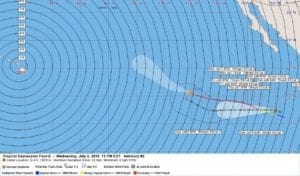
LOCATION…12.4N 109.9W
ABOUT 725 MI…1165 KM S OF THE SOUTHERN TIP OF BAJA CALIFORNIA
ABOUT 590 MI…945 KM SW OF MANZANILLO MEXICO
MAXIMUM SUSTAINED WINDS…35 MPH…55 KM/H
PRESENT MOVEMENT…WNW OR 285 DEGREES AT 8 MPH…13 KM/H
MINIMUM CENTRAL PRESSURE…1006 MB…29.71 INCHES
WATCHES AND WARNINGS
——————–
There are no coastal watches or warnings in effect.
DISCUSSION AND 48-HOUR OUTLOOK
——————————
At 900 PM MDT (0300 UTC), the center of Tropical Depression Four-E
was estimated near latitude 12.4 North, longitude 109.9 West. The
depression is moving toward the west-northwest near 8 mph (13 km/h).
A turn toward the west is expected on Thursday, and this motion
should continue for the next 2 days.
Maximum sustained winds are near 35 mph (55 km/h) with higher
gusts. The depression is forecast to become a tropical storm on
Thursday.
The estimated minimum central pressure is 1006 mb (29.71 inches).
HAZARDS AFFECTING LAND
———————-
None.
NEXT ADVISORY
————-
Next complete advisory at 300 AM MDT.
$$
Forecaster Avila
000
WTPZ44 KNHC 070234
TCDEP4
TROPICAL DEPRESSION FOUR-E DISCUSSION NUMBER 2
NWS NATIONAL HURRICANE CENTER MIAMI FL EP042016
900 PM MDT WED JUL 06 2016
The depression is not in a hurry to intensify tonight. The
circulation is better defined, and although the convection is not
very deep at this time, it is acquiring a comma-shape form, which
suggests an increase in the convective pattern organization. The
center appears to be located on the nose of the comma, but is not
embedded within the thunderstorm activity. T-numbers from SAB, TAFB
and ADTs from CIMSS are near 2.0 on the Dvorak scale. On this
basis, the initial intensity is kept at 30 kt.
The depression is embedded within a very favorable environment of
low shear for intensification, and only the upwelling left by strong
Hurricane Blas could cause a delay in the intensification process.
Most of the intensity guidance shows a substantial increase in the
winds by the end of the forecast period and in fact, the SHIPS model
increases the winds to above 100 kt. The NHC forecast follows the
model trend and makes the depression a hurricane in 3 days, but this
could happen earlier.
The depression is moving toward the west-northwest or 285 degrees
at 7 kt. Most of the global models amplify a very strong and nearly
stationary subtropical ridge which extends from the United States
westward across the Pacific. This steering pattern will likely force
the cyclone to move westward and even south of due west for 3 to
4 days. After that time the cyclone will begin to turn more to the
west-northwest around the southwestern periphery of the ridge. Most
of the track models are in agreement with this solution, and the NHC
forecast is in the middle of the guidance envelope, but favoring the
consensus between the GFS and the ECMWF global models.
FORECAST POSITIONS AND MAX WINDS
INIT 07/0300Z 12.4N 109.9W 30 KT 35 MPH
12H 07/1200Z 12.5N 111.0W 35 KT 40 MPH
24H 08/0000Z 12.5N 112.5W 45 KT 50 MPH
36H 08/1200Z 12.5N 114.0W 55 KT 65 MPH
48H 09/0000Z 12.5N 115.5W 60 KT 70 MPH
72H 10/0000Z 12.5N 119.0W 75 KT 85 MPH
96H 11/0000Z 12.5N 122.0W 85 KT 100 MPH
120H 12/0000Z 14.5N 126.0W 90 KT 105 MPH
$$
Forecaster Avila


