000
WTPZ33 KNHC 070234
TCPEP3
BULLETIN
HURRICANE BLAS ADVISORY NUMBER 17
NWS NATIONAL HURRICANE CENTER MIAMI FL EP032016
800 PM PDT WED JUL 06 2016
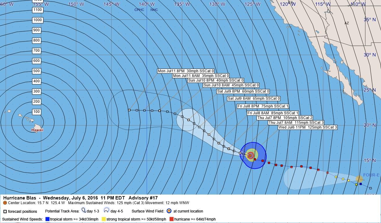
…BLAS HOLDING ITS STRENGTH AS A CATEGORY 3 HURRICANE…
SUMMARY OF 800 PM PDT…0300 UTC…INFORMATION
———————————————-
LOCATION…15.7N 125.4W
ABOUT 1125 MI…1810 KM WSW OF THE SOUTHERN TIP OF BAJA CALIFORNIA
MAXIMUM SUSTAINED WINDS…125 MPH…205 KM/H
PRESENT MOVEMENT…WNW OR 290 DEGREES AT 12 MPH…19 KM/H
MINIMUM CENTRAL PRESSURE…956 MB…28.23 INCHES
WATCHES AND WARNINGS
——————–
There are no coastal watches or warnings in effect.
DISCUSSION AND 48-HOUR OUTLOOK
——————————
At 800 PM PDT (0300 UTC), the eye of Hurricane Blas was located
near latitude 15.7 North, longitude 125.4 West. Blas is moving
toward the west-northwest near 12 mph (19 km/h) and this general
motion is expected to continue through Thursday night. A turn
toward
the northwest is forecast on Friday.
Maximum sustained winds remain near 125 mph (205 km/h) with higher
gusts. Blas is a category 3 hurricane on the Saffir-Simpson
Hurricane Wind Scale. Gradual weakening is forecast during the next
48 hours.
Hurricane-force winds extend outward up to 40 miles (65 km) from the
center and tropical-storm-force winds extend outward up to 160 miles
(260 km).
The estimated minimum central pressure is 956 mb (28.23 inches).
HAZARDS AFFECTING LAND
———————-
None.
NEXT ADVISORY
————-
Next complete advisory at 200 AM PDT.
$$
Forecaster Cangialosi
000
WTPZ43 KNHC 070234
TCDEP3
HURRICANE BLAS DISCUSSION NUMBER 17
NWS NATIONAL HURRICANE CENTER MIAMI FL EP032016
800 PM PDT WED JUL 06 2016
The satellite presentation of Blas remains quite impressive. The eye
of the hurricane is about 20-25 n mi wide with evidence of
mesovorticies within it. The convective structure has changed
little throughout the day and remains fairly symmetric around the
center. A blend of the latest Dvorak classifications from TAFB,
SAB, and the automated technique from CIMSS at the University of
Wisconsin suggest that the intensity of Blas is holding steady at
around 110 kt.
The major hurricane is not far away from cool water, and it
will likely be crossing the 26 C isotherm in about 12 hours.
These anticipated unfavorable oceanic conditions combined with a
progressively more stable air mass should promote a steady
weakening trend during the next several days. The NHC intensity
forecast is an update of the previous one and is fairly close to the
intensity model consensus. The system is forecast to become a
post-tropical cyclone in about 4 days when sea surface temperatures
beneath the cyclone will likely be around 24 C.
Blas is moving west-northwestward at about 10 kt on the
southwestern periphery of a sprawling mid-level ridge. This general
motion should continue for the next couple of days as the ridge
remains the primary steering influence. Beyond that time, the
forecast track is less certain as the model spread remains quite
large with the GFS-based guidance showing a northwestward motion
around the east side of a mid- to upper-level low northeast of
the Hawaiian Islands. Conversely, the ECMWF and UKMET models show
less interaction with the upper low, resulting in a more westward
track. The NHC track forecast remains near the middle of the
guidance envelope and is in best agreement with the consensus aids.
FORECAST POSITIONS AND MAX WINDS
INIT 07/0300Z 15.7N 125.4W 110 KT 125 MPH
12H 07/1200Z 16.1N 126.8W 100 KT 115 MPH
24H 08/0000Z 16.7N 128.4W 90 KT 105 MPH
36H 08/1200Z 17.5N 129.8W 75 KT 85 MPH
48H 09/0000Z 18.7N 131.2W 65 KT 75 MPH
72H 10/0000Z 20.8N 134.1W 50 KT 60 MPH
96H 11/0000Z 22.1N 138.2W 35 KT 40 MPH…POST-TROPICAL
120H 12/0000Z 22.2N 142.5W 25 KT 30 MPH…POST-TROP/REMNT LOW
$$
Forecaster Cangialosi


Leave a Reply