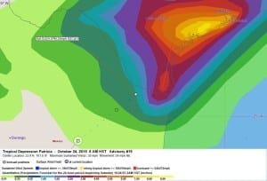
Very heavy rainfall is likely to cause life- threatening flash floods and mudslides in the Mexican states of Nayarit, Jalisco, Colima, Michoacan and Guerrero through today.
000
WTPZ35 KNHC 241432
TCPEP5
BULLETIN
TROPICAL DEPRESSION PATRICIA ADVISORY NUMBER 19
NWS NATIONAL HURRICANE CENTER MIAMI FL EP202015
1000 AM CDT SAT OCT 24 2015
…PATRICIA WEAKENS TO A TROPICAL DEPRESSION OVER CENTRAL MEXICO…
…HEAVY RAIN THREAT CONTINUES…
SUMMARY OF 1000 AM CDT…1500 UTC…INFORMATION
———————————————–
LOCATION…23.9N 101.6W
ABOUT 95 MI…155 KM NE OF ZACATECAS MEXICO
MAXIMUM SUSTAINED WINDS…35 MPH…55 KM/H
PRESENT MOVEMENT…NE OR 40 DEGREES AT 24 MPH…39 KM/H
MINIMUM CENTRAL PRESSURE…1002 MB…29.59 INCHES
WATCHES AND WARNINGS
——————–
There are no coastal watches or warnings in effect.
DISCUSSION AND 48-HOUR OUTLOOK
——————————
At 1000 AM CDT (1500 UTC), the center of Tropical Depression
Patricia was located near latitude 23.9 North, longitude 101.6 West.
The depression is moving toward the northeast near 24 mph (39 km/h)
and this motion is expected to continue through tonight. On the
forecast track, the center of Patricia will move across central and
northeastern Mexico today and tonight.
Maximum sustained winds have decreased to near 35 mph (55 km/h)
with higher gusts. Patricia is expected to degenerate to a remnant
low pressure area later today or tonight over northeastern Mexico.
The estimated minimum central pressure is 1002 mb (29.59 inches).
HAZARDS AFFECTING LAND
———————-
WIND: Wind gusts to tropical-storm force are possible near the
center through this afternoon, especially in higher elevations.
RAINFALL: Patricia is expected to produce total rainfall
accumulations of 8 to 12 inches, with isolated maximum amounts of
20 inches, over the Mexican states of Nayarit, Jalisco, Colima,
Michoacan, and Guerrero through Saturday. In addition, the heavy
rain threat ahead of Patricia or its remnants will increase Saturday
across northeast Mexico into coastal sections of Texas. This heavy
rain threat will continue across the western Gulf Coast through this
weekend and spread into the central Gulf Coast by early next week.
These rains are likely to produce life-threatening flash floods and
mudslides.
STORM SURGE: Water levels are expected to gradually subside but
will remain above normal through this afternoon.
NEXT ADVISORY
————-
Next complete advisory at 400 PM CDT.
$$
Forecaster Beven
000
WTPZ45 KNHC 241434
TCDEP5
TROPICAL DEPRESSION PATRICIA DISCUSSION NUMBER 19
NWS NATIONAL HURRICANE CENTER MIAMI FL EP202015
1000 AM CDT SAT OCT 24 2015
Patricia continues to weaken rapidly over the mountains of central
Mexico. Satellite imagery and surface observations indicate that
the mid- to upper-level center is now displaced to the northeast of
the surface center, and there is little organized convection
associated with the cyclone. The initial intensity is reduced to
30 kt based mainly on surface observations, and this could be
generous. Patricia is likely to degenerate to a remnant low or
trough during the next 6-12 hours as it moves northeastward into
northeastern Mexico.
A low pressure area is developing over southern Texas, with the
system forecast to move over the northwestern Gulf of Mexico later
in the weekend. This system should be non-tropical in nature.
However, the low is likely to absorb the remnants of Patricia along
with the associated moisture, and this is expected to result in
locally heavy rainfall over portions of the northwestern Gulf of
Mexico coastal area. Refer to statements from local National
Weather Service forecast offices for details on this system.
KEY MESSAGES:
1. Even though Patricia is weakening rapidly, continued very heavy
rainfall is likely to cause life- threatening flash floods and
mudslides in the Mexican states of Nayarit, Jalisco, Colima,
Michoacan and Guerrero through today.
FORECAST POSITIONS AND MAX WINDS
INIT 24/1500Z 23.9N 101.6W 30 KT 35 MPH
12H 25/0000Z 26.0N 99.0W 20 KT 25 MPH…POST-TROP/REMNT LOW
24H 25/1200Z…DISSIPATED
$$
Forecaster Beven


Leave a Reply