Tropical Depression Three-E July 2, 2016 Advisory #1
000
WTPZ33 KNHC 030233
TCPEP3
BULLETIN
TROPICAL DEPRESSION THREE-E ADVISORY NUMBER 1
NWS NATIONAL HURRICANE CENTER MIAMI FL EP032016
900 PM MDT SAT JUL 02 2016
…NEW TROPICAL DEPRESSION FORMS WELL SOUTHWEST OF MEXICO…
…EXPECTED TO STRENGTHEN…
SUMMARY OF 900 PM MDT…0300 UTC…INFORMATION
———————————————-
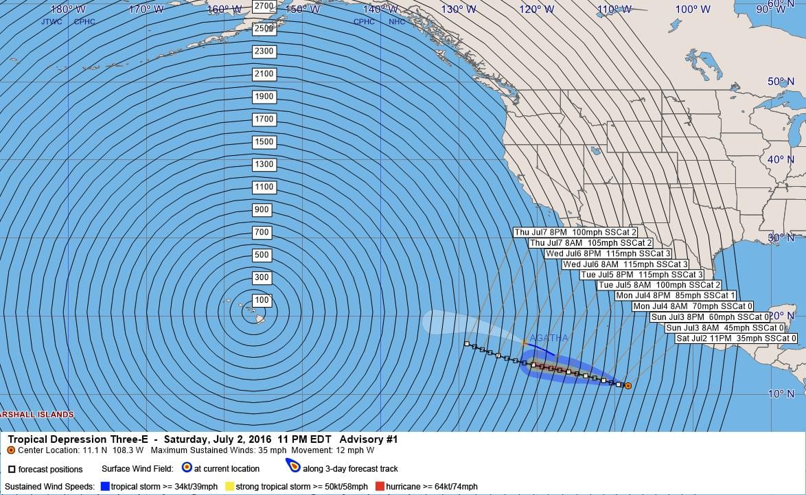
LOCATION…11.1N 108.3W
ABOUT 605 MI…975 KM SSW OF MANZANILLO MEXICO
MAXIMUM SUSTAINED WINDS…35 MPH…55 KM/H
PRESENT MOVEMENT…W OR 280 DEGREES AT 12 MPH…19 KM/H
MINIMUM CENTRAL PRESSURE…1007 MB…29.74 INCHES
WATCHES AND WARNINGS
——————–
There are no coastal watches or warnings in effect.
DISCUSSION AND 48-HOUR OUTLOOK
——————————
At 900 PM MDT (0300 UTC), the center of Tropical Depression Three-E
was located near latitude 11.1 North, longitude 108.3 West. The
depression is moving toward the west near 12 mph (19 km/h), and a
general westward to west-northwestward motion at a similar forward
speed is expected to continue through Monday.
Maximum sustained winds are near 35 mph (55 km/h) with higher gusts.
Strengthening is forecast during the next 48 hours, and the
depression is forecast to become a tropical storm by Sunday and
reach hurricane strength on Monday.
The estimated minimum central pressure is 1007 mb (29.74 inches).
HAZARDS AFFECTING LAND
———————-
None
NEXT ADVISORY
————-
Next complete advisory at 300 AM MDT.
$$
Forecaster Brennan
000
WTPZ43 KNHC 030237
TCDEP3
TROPICAL DEPRESSION THREE-E DISCUSSION NUMBER 1
NWS NATIONAL HURRICANE CENTER MIAMI FL EP032016
900 PM MDT SAT JUL 02 2016
The deep convection associated with the area of low pressure well
southwest of Manzanillo has become much better organized during the
past 6 to 12 hours, and this system is now classified as a tropical
cyclone. Satellite imagery shows a large convective canopy with
multiple curved bands. The estimated center position is near the
eastern edge of the deep convection and the initial intensity is set
to 30 kt based on the latest Dvorak classification from TAFB.
The environment appears conducive for at least steady strengthening
during the next 3 days, as the cyclone will be moving over SSTs of
29-30C and in an environment of low to moderate shear and abundant
moisture. The NHC intensity forecast shows the system becoming a
tropical storm tonight or early Sunday and becoming a hurricane on
Monday. The system is expected to peak in intensity in 3 to 4 days
near major hurricane strength before gradual weakening begins as the
center moves over progressively cooler waters. The official
forecast is above the intensity consensus and close to a blend of
the SHIPS, LGEM, and HWRF models.
The initial motion estimate is a somewhat uncertain 280/10 given the
recent formation of the system. The dominant steering mechanism
through the forecast period will be the western periphery of a
subtropical ridge centered over northern Mexico and the southern
United States. This pattern should guide the cyclone on a general
westward to west-northwestward motion during the next 5 days. Most
of the track model guidance is in good agreement on this scenario
with the exception of the GFDL model, which is well to the right.
There is some along-track spread between the generally slower GFS
model and the faster ECMWF and HWRF through much of the period. The
across-track spread increases in 4-5 days with the GFS and GEFS
ensemble mean showing more of a poleward turn as they erode the
ridge more, while the ECMWF, ECMWF ensemble mean, and UKMET have a
stronger ridge and more westward motion. The NHC track forecast is
close to a blend of these two camps through the forecast period and
is of about average confidence.
FORECAST POSITIONS AND MAX WINDS
INIT 03/0300Z 11.1N 108.3W 30 KT 35 MPH
12H 03/1200Z 11.3N 109.6W 40 KT 45 MPH
24H 04/0000Z 11.8N 111.5W 50 KT 60 MPH
36H 04/1200Z 12.4N 113.8W 60 KT 70 MPH
48H 05/0000Z 12.9N 116.0W 75 KT 85 MPH
72H 06/0000Z 13.8N 120.5W 100 KT 115 MPH
96H 07/0000Z 15.0N 125.0W 100 KT 115 MPH
120H 08/0000Z 16.5N 129.0W 85 KT 100 MPH
$$
Forecaster Brennan


Leave a Reply