WTPA33 PHFO 230856
TCPCP3
BULLETIN
TROPICAL STORM DARBY ADVISORY NUMBER 47
NWS CENTRAL PACIFIC HURRICANE CENTER HONOLULU HI EP052016
1100 PM HST FRI JUL 22 2016
…DARBY EXPECTED TO REACH THE BIG ISLAND SATURDAY…
SUMMARY OF 1100 PM HST…0900 UTC…INFORMATION
———————————————–
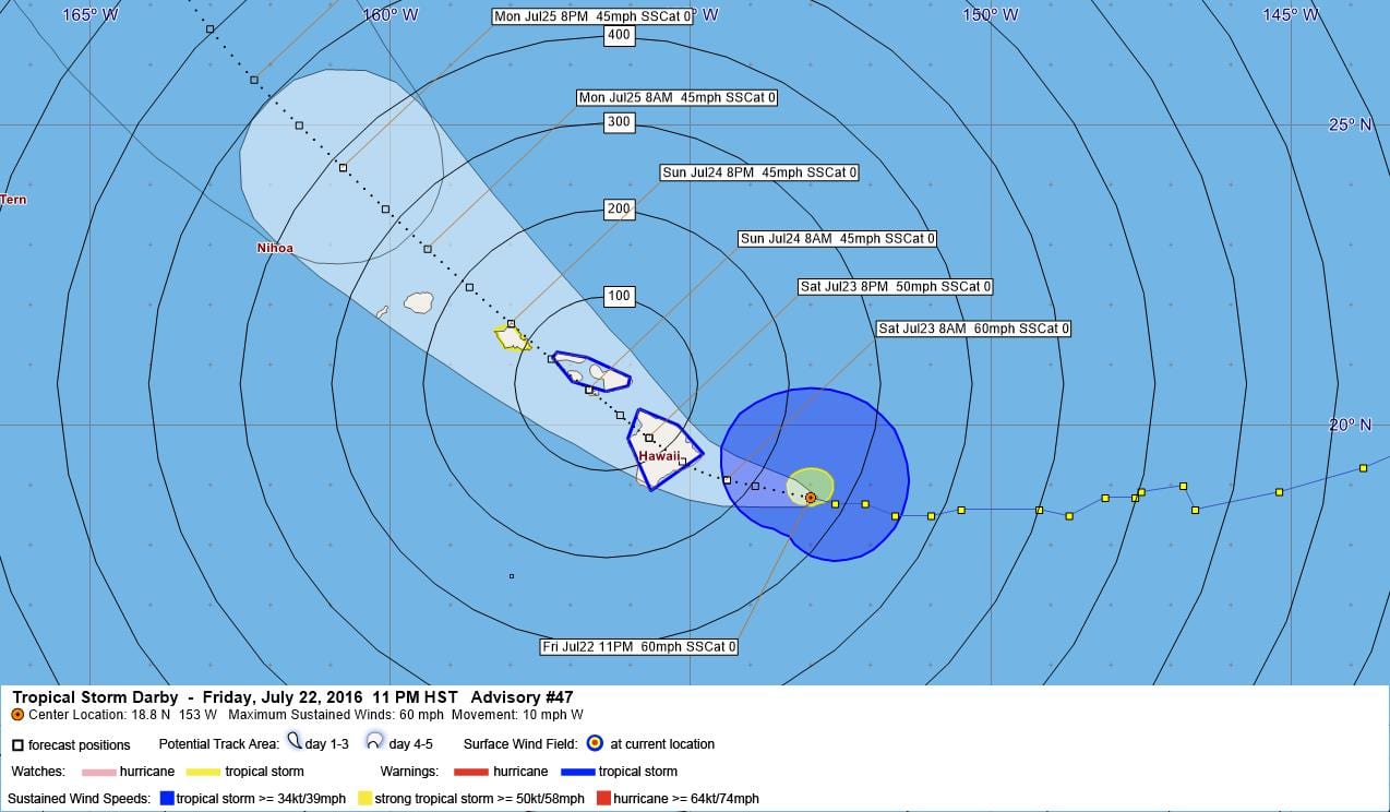
LOCATION…18.8N 153.0W
ABOUT 150 MI…240 KM ESE OF HILO HAWAII
ABOUT 360 MI…580 KM ESE OF HONOLULU HAWAII
MAXIMUM SUSTAINED WINDS…60 MPH…95 KM/H
PRESENT MOVEMENT…W OR 280 DEGREES AT 10 MPH…17 KM/H
MINIMUM CENTRAL PRESSURE…1000 MB…29.53 INCHES
WATCHES AND WARNINGS
——————–
CHANGES WITH THIS ADVISORY:
None.
SUMMARY OF WATCHES AND WARNINGS IN EFFECT:
A Tropical Storm Warning is in effect for…
* Hawaii County
* Maui County, including the islands of Maui, Molokai, Lanai and
Kahoolawe
A Tropical Storm Watch is in effect for…
* Oahu
A Tropical Storm Warning means that tropical storm conditions are
expected within the warning area within 36 hours.
A Tropical Storm Watch means that tropical storm conditions are
possible within the watch area within 48 hours.
Interests elsewhere in the Hawaiian Islands should monitor the
progress of Darby. Watches and warnings may be required for
additional islands later tonight or Saturday.
For storm information specific to your area, please monitor
products issued by the National Weather Service office in
Honolulu Hawaii.
DISCUSSION AND 48-HOUR OUTLOOK
——————————
At 1100 PM HST (0900 UTC), the center of Tropical Storm Darby was
located near latitude 18.8 North, longitude 153.0 West. Darby is
moving toward the west near 10 mph (17 km/h). Darby’s forward
motion is expected to slow slightly Saturday followed by a turn
toward the northwest Saturday night. On the forecast track, the
center of Darby is forecast to pass over the Big Island on
Saturday, and Maui on Saturday night.
Maximum sustained winds are near 60 mph (95 km/h) with higher gusts.
Some weakening is forecast during the next 48 hours.
Tropical-storm-force winds extend outward up to 125 miles (205 km)
from the center.
The estimated minimum central pressure is 1000 mb (29.53 inches).
HAZARDS AFFECTING LAND
———————-
WIND: Tropical storm force winds are expected over the Big Island
starting late tonight, and over portions of Maui County on
Saturday. Tropical storm force winds are possible over Oahu
Saturday night or Sunday.
SURF: Swells generated by Darby are expected to impact the
Hawaiian Islands over the next couple of days.
RAINFALL: Storm total rainfall of 10 to 15 inches with locally
higher amounts…could cause life-threatening flash floods as well
as landslides.
NEXT ADVISORY
————-
Next intermediate advisory at 200 AM HST.
Next complete advisory at 500 AM HST.
$$
Forecaster Powell
WTPA43 PHFO 230856
TCDCP3
TROPICAL STORM DARBY DISCUSSION NUMBER 47
NWS CENTRAL PACIFIC HURRICANE CENTER HONOLULU HI EP052016
1100 PM HST FRI JUL 22 2016
Darby’s satellite presentation continues to be messy, with deep
convection now on the decline and beginning to wrap around the
south and southwest quadrants. Cloud tops have warmed over the past
six hours and the best outflow continues to be toward the
northeast, consistent with southwesterly shear near 10 kt depicted
by SHIPS. The 53rd Weather Reconnaissance Squadron’s WC-130J
aircraft did a fine job this evening finding the center of this
system, so we are confident we know where Darby is and how it is
moving. Based on aircraft SFMR data from the first pass through the
center, we will keep an initial intensity of 50 kt for this
advisory. Like before, this is higher than the objective Dvorak
satellite intensity estimates from the three satellite analysis
centers (HFO, JTWC and SAB). These range from 30 kt to 45 kt.
Interestingly, an 0630 UTC ASCAT pass only found 35 kt within the
northeast quadrant. The next aircraft reconnaissance mission into
Darby will be Saturday morning.
Initial motion is 280/09 kt as Darby slowly gains latitude along the
southern flank of a subtropical ridge. Low pressure farther to the
north is expected to dig southward, weakening the ridge. This will
simultaneously slow Darby’s forward motion and deflect it to a more
northwesterly track. Vertical wind shear will also increase,
especially after 18 hours according to SHIPS, likely leading to
gradual weakening from 24 hours and beyond. Track guidance has
changed very little over the past 6 to 12 hours, depicting a gently
curving path across the main Hawaiian Island chain. The forecast
for this advisory track has changed very little and remains well
within the tightening guidance envelope and close to TVCN consensus.
This track takes Darby directly across the Big Island of Hawaii
between 12 and 24 hours.
The intensity forecast is based on the gradual toll that increasing
vertical shear will take on Darby, overtaking any sustaining
effects from marginal sea surface temperatures. However, this shear
is not expected to become strong until day 2. The forecast
calls for slow weakening with Darby maintaining tropical storm
strength through the weekend. This is consistent with the previous
package and represents a compromise between SHIPS, which weakens
DARBY quickly, and GHMI, which keeps Darby as a strong tropical
storm through day 5. It is important to note that weakening
due to land interaction has so far been ignored for that portion of
the track beyond the Big Island.
Interests outside of the watch and warning areas in the Hawaiian
Islands should continue to monitor the progress of Darby. Remember,
it is important not to focus too closely on the exact track and
intensity forecasts because the average track error 72 hours out is
near 100 miles, while the average intensity error is about 15 kt. In
addition, the hazards of a tropical cyclone can extend over a broad
area well away from the center.
FORECAST POSITIONS AND MAX WINDS
INIT 23/0900Z 18.8N 153.0W 50 KT 60 MPH
12H 23/1800Z 19.1N 154.4W 50 KT 60 MPH
24H 24/0600Z 19.8N 155.7W 45 KT 50 MPH
36H 24/1800Z 20.6N 156.7W 40 KT 45 MPH
48H 25/0600Z 21.7N 158.0W 40 KT 45 MPH
72H 26/0600Z 24.3N 160.8W 40 KT 45 MPH
96H 27/0600Z 27.6N 163.7W 35 KT 40 MPH
120H 28/0600Z 31.9N 166.3W 30 KT 35 MPH
$$
Forecaster Powell


Leave a Reply