WTPA33 PHFO 231759
TCPCP3
BULLETIN
TROPICAL STORM DARBY INTERMEDIATE ADVISORY NUMBER 48A
NWS CENTRAL PACIFIC HURRICANE CENTER HONOLULU HI EP052016
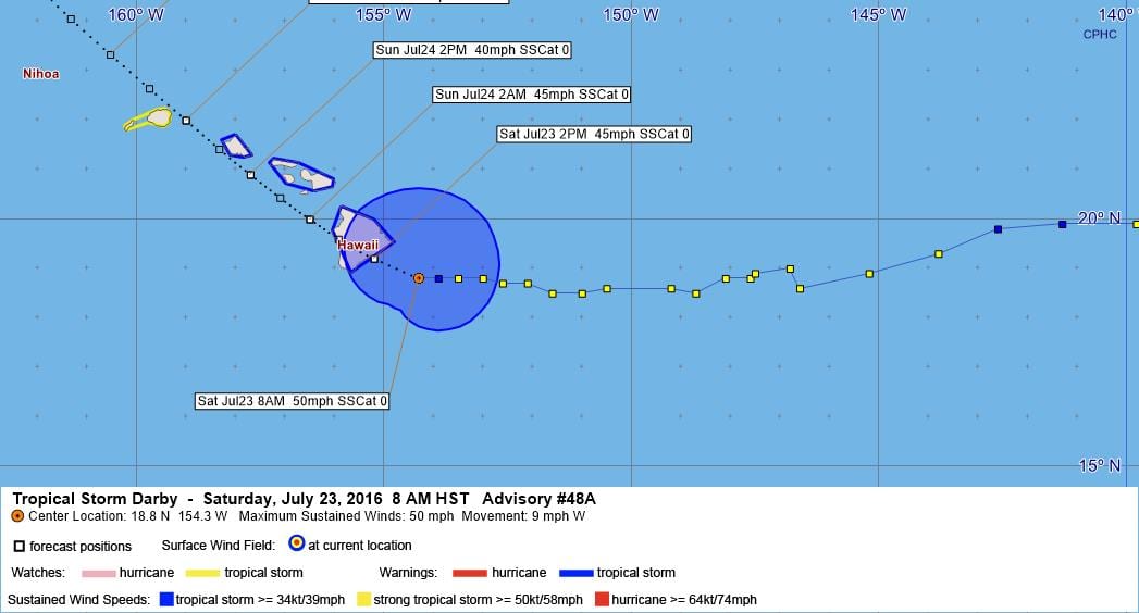
800 AM HST SAT JUL 23 2016
…DARBY TRACKING SLOWLY TOWARD THE BIG ISLAND…
SUMMARY OF 800 AM HST…1800 UTC…INFORMATION
———————————————-
LOCATION…18.8N 154.3W
ABOUT 80 MI…130 KM SE OF HILO HAWAII
ABOUT 295 MI…475 KM ESE OF HONOLULU HAWAII
MAXIMUM SUSTAINED WINDS…50 MPH…85 KM/H
PRESENT MOVEMENT…W OR 275 DEGREES AT 9 MPH…15 KM/H
MINIMUM CENTRAL PRESSURE…1002 MB…29.59 INCHES
WATCHES AND WARNINGS
——————–
CHANGES WITH THIS ADVISORY:
None.
SUMMARY OF WATCHES AND WARNINGS IN EFFECT:
A Tropical Storm Warning is in effect for…
* Hawaii County
* Maui County, including the islands of Maui, Molokai, Lanai and
Kahoolawe
* Oahu
A Tropical Storm Watch is in effect for…
* Kauai
A Tropical Storm Warning means that tropical storm conditions are
expected within the warning area within 36 hours.
A Tropical Storm Watch means that tropical storm conditions are
possible within the watch area within 48 hours.
Interests in the eastern portion of the Papahanaumokuakea Marine
National Monument should monitor the progress of Darby.
For storm information specific to your area, please monitor
products issued by the National Weather Service office in
Honolulu.
DISCUSSION AND 48-HOUR OUTLOOK
——————————
At 800 AM HST (1800 UTC), the center of Tropical Storm Darby was
located by aircraft and radar near latitude 18.8 North, longitude
154.3 West. Darby is moving toward the west near 9 mph (15 km/h).
Darby’s forward motion is expected to slow slightly today followed
by a gradual turn toward the northwest tonight and Sunday. On the
forecast track, the center of Darby is forecast to pass over the Big
Island later today and close to Maui County tonight. Darby will
approach Oahu on Sunday and Kauai Monday.
Maximum sustained winds are near 50 mph (85 km/h) with higher gusts.
Some weakening is forecast during the next 48 hours.
Tropical-storm-force winds extend outward up to 125 miles (205 km)
from the center.
The estimated minimum central pressure is 1002 mb (29.59 inches).
HAZARDS AFFECTING LAND
———————-
WIND: Tropical storm force winds are expected over the Big Island
today, over portions of Maui County this afternoon and evening, and
over Oahu Sunday. Tropical storm force winds are possible over Kauai
Monday.
SURF: Swells generated by Darby are expected to impact the
Hawaiian Islands over the next couple of days.
RAINFALL: Storm total rainfall of 10 to 15 inches, with possible
isolated maximum amounts of 20 inches. These rains could
produce life-threatening flash floods and landslides.
NEXT ADVISORY
————-
Next complete advisory at 1100 AM HST.
$$
Forecaster Birchard
WTPA43 PHFO 231459
TCDCP3
TROPICAL STORM DARBY DISCUSSION NUMBER 48
NWS CENTRAL PACIFIC HURRICANE CENTER HONOLULU HI EP052016
500 AM HST SAT JUL 23 2016
Deep convection associated with Darby has increased once again this
morning, with the bulk of this activity now across the system’s
southeast semicircle. Outflow remains best within the northeast
quadrant, but is restricted throughout the south semicircle, thanks
to continued 7 to 10 kt southwest shear. Low cloud swirls east of
the LLCC add confidence to the initial position based heavily on
satellite fixes. However, Darby continues to defy predictions to
gain latitude. Given the continued messy satellite presentation and
the lack of aircraft data for this package, it’s possible that this
system is a tenth of a degree or two farther south. The next
forecast package may benefit from land-based weather radar position
estimates. Initial intensity is decreased to 45 kt as a compromise
between continued 35 kt objective Dvorak satellite intensity
estimates and earlier SFMR intensity from reconnaissance aircraft.
The next aircraft reconnaissance mission will be later this morning.
Initial motion is 275/08 kt, representing a gradual slowing over
the past 12 hours. However, this is a 12 hour motion. Darby has not
gained latitude over the past 6 hours and we may find out later
that a small southward component exists when radar estimates become
available. Darby is moving westward along the southern flank of the
subtropical ridge. Global models continue to depict a weakness in
this ridge between 150W and 160W due to low pressure digging in from
the north. All models continue to show Darby slowing and
gradually turning northwest along various curving paths through the
next five days. Track guidance remains tightly packed but shifts
slightly to the left, with all tracks crossing the Big Island.
The right outlier remains GFDL, which takes Darby over Oahu after
passing across leeward waters. The right outlier is the Canadian
model, which takes Darby west of Kauai after its encounter with the
Big Island. The forecast track was tapped to the left again though
day 4 to keep pace with initial motion and to maintain the track
within the guidance envelope. This track, closely following TVCN
consensus, takes Darby to the Big Island in 12 hours.
The intensity forecast continues to be based on the expected toll of
increasing vertical shear on Darby, which gradually overtakes any
sustaining effects from marginal sea surface temperatures. However,
this shear is not expected to become strong until after 18 hours.
The forecast calls for slow weakening with Darby maintaining
tropical storm strength through the weekend. While initial intensity
is decreased to 45 kt, this forecast weakening trend is consistent
with the previous package, is close to IVCN guidance and represents
a compromise between SHIPS and HWRF, which weaken DARBY quickly, and
GHMI, which keeps Darby as a tropical storm through day 5. It is
important to note that weakening due to land interaction has so far
been ignored for that portion of the track beyond the Big Island.
Interests outside of the watch and warning areas in the Hawaiian
Islands should continue to monitor the progress of Darby. Remember,
it is important not to focus too closely on the exact track and
intensity forecasts because the average track error 72 hours out is
near 100 miles, while the average intensity error is about 15 kt. In
addition, the hazards of a tropical cyclone can extend over a broad
area well away from the center.
FORECAST POSITIONS AND MAX WINDS
INIT 23/1500Z 18.8N 153.9W 45 KT 50 MPH
12H 24/0000Z 19.2N 155.2W 40 KT 45 MPH
24H 24/1200Z 20.0N 156.5W 40 KT 45 MPH
36H 25/0000Z 20.9N 157.7W 35 KT 40 MPH
48H 25/1200Z 22.0N 159.0W 35 KT 40 MPH
72H 26/1200Z 24.8N 162.1W 35 KT 40 MPH
96H 27/1200Z 28.2N 164.9W 30 KT 35 MPH
120H 28/1200Z 32.7N 167.0W 30 KT 35 MPH
$$
Forecaster Powell


Leave a Reply