000
WTPZ31 KNHC 212035
TCPEP1
BULLETIN
TROPICAL STORM ESTELLE ADVISORY NUMBER 26
NWS NATIONAL HURRICANE CENTER MIAMI FL EP062016
200 PM PDT THU JUL 21 2016
…ESTELLE SLOWLY WEAKENING…
SUMMARY OF 200 PM PDT…2100 UTC…INFORMATION
———————————————-
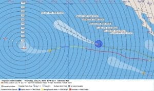
LOCATION…20.7N 129.7W
ABOUT 1275 MI…2055 KM W OF THE SOUTHERN TIP OF BAJA CALIFORNIA
MAXIMUM SUSTAINED WINDS…50 MPH…85 KM/H
PRESENT MOVEMENT…WNW OR 290 DEGREES AT 16 MPH…26 KM/H
MINIMUM CENTRAL PRESSURE…1002 MB…29.59 INCHES
WATCHES AND WARNINGS
——————–
There are no coastal watches or warnings in effect.
DISCUSSION AND 48-HOUR OUTLOOK
——————————
At 200 PM PDT (2100 UTC), the center of Tropical Storm Estelle was
located near latitude 20.7 North, longitude 129.7 West. Estelle is
moving toward the west-northwest near 16 mph (26 km/h) and this
general motion is expected to continue for the next couple of
days.
Maximum sustained winds have decreased to near 50 mph (85 km/h)
with higher gusts. Additional weakening is forecast, and Estelle
is forecast to become a post-tropical remnant low on Friday.
Tropical-storm-force winds extend outward up to 105 miles (165 km)
from the center.
The estimated minimum central pressure is 1002 mb (29.59 inches).
HAZARDS AFFECTING LAND
———————-
None.
NEXT ADVISORY
————-
Next complete advisory at 800 PM PDT.
$$
Forecaster Brennan
000
WTPZ41 KNHC 212036
TCDEP1
TROPICAL STORM ESTELLE DISCUSSION NUMBER 26
NWS NATIONAL HURRICANE CENTER MIAMI FL EP062016
200 PM PDT THU JUL 21 2016
Estelle is gradually weakening, with the convection warming west
of the center during the past few hours. The initial intensity is
set to 45 kt based on the latest Dvorak estimates from TAFB and
SAB. Further weakening is expected as Estelle will be moving over
SSTs of less than 23C with an increase in shear, which should result
in Estelle losing organized deep convection and becoming post-
tropical in about 24 hours, or even a little sooner. The remnant
low of Estelle is expected to dissipate after 72 hours.
The initial motion estimate is 290/14. Estelle is being steered by
a mid-level ridge centered well to the east over the south-central
United States. Estelle should continue moving around the periphery
of the ridge and turn a bit more poleward by 36 hours, and this
motion should continue through dissipation. The new NHC track
forecast is again adjusted to the left of the previous one
following the latest trend in the guidance. The official forecast
is close to the latest ECMWF and lies a bit north of the new
multi-model consensus aid TVCN.
FORECAST POSITIONS AND MAX WINDS
INIT 21/2100Z 20.7N 129.7W 45 KT 50 MPH
12H 22/0600Z 21.4N 131.8W 35 KT 40 MPH
24H 22/1800Z 22.5N 134.5W 30 KT 35 MPH…POST-TROP/REMNT LOW
36H 23/0600Z 23.9N 136.9W 25 KT 30 MPH…POST-TROP/REMNT LOW
48H 23/1800Z 25.4N 139.4W 20 KT 25 MPH…POST-TROP/REMNT LOW
72H 24/1800Z 27.7N 143.6W 20 KT 25 MPH…POST-TROP/REMNT LOW
96H 25/1800Z…DISSIPATED
$$
Forecaster Brennan


Leave a Reply