Storm Summary for Tropical Storm Flossie
Saturday, July 27, 2013 at 11 PM HST(Output from Hurrevac, based on Central Pacific Hurricane Center Forecast Advisory # 14)
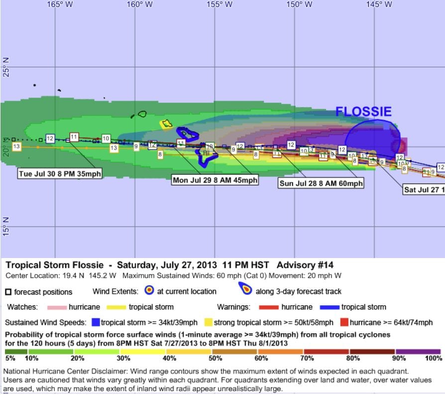
Tropical Storm Flossie 14 is currently a tropical storm on the Saffir-Simpson Hurricane Wind Scale, with maximum sustained winds of 60 mph (50 kts), moving west-northwest at 20 mph. The estimated minimum central pressure is 998 mb. Tropical storm-force winds extend outward up to 175 miles (280 km) from the storm center. Certain coastal locations are under Tropical Storm Warning and Tropical Storm Watch as illustrated in the map below. The geographic extents of these watches and warnings are detailed in the advisory text at the end of this report.
WTPA31 PHFO 280903
TCPCP1
BULLETIN
TROPICAL STORM FLOSSIE ADVISORY NUMBER 14
NWS CENTRAL PACIFIC HURRICANE CENTER HONOLULU HI EP062013
1100 PM HST SAT JUL 27 2013
…FLOSSIE CONTINUES AS A THREAT TO THE STATE OF HAWAII…
SUMMARY OF 1100 PM HST…0900 UTC…INFORMATION
———————————————–
LOCATION…19.4N 145.2W
ABOUT 645 MI…1040 KM E OF HILO HAWAII
ABOUT 835 MI…1340 KM E OF HONOLULU HAWAII
MAXIMUM SUSTAINED WINDS…60 MPH…95 KM/H
PRESENT MOVEMENT…W OR 275 DEGREES AT 20 MPH…32 KM/H
MINIMUM CENTRAL PRESSURE…998 MB…29.47 INCHES
WATCHES AND WARNINGS
——————–
CHANGES WITH THIS ADVISORY…
A TROPICAL STORM WARNING HAS BEEN ISSUED FOR HAWAII AND MAUI
COUNTIES.
A TROPICAL STORM WATCH HAS BEEN ISSUED FOR OAHU.
SUMMARY OF WATCHES AND WARNINGS IN EFFECT…
A TROPICAL STORM WARNING IS IN EFFECT FOR…
*HAWAII COUNTY
*MAUI COUNTY…INCLUDING THE ISLANDS OF MAUI…MOLOKAI…LANAI AND
KAHOOLAWE
A TROPICAL STORM WATCH IS IN EFFECT FOR
*OAHU
A TROPICAL STORM WARNING MEANS THAT TROPICAL STORM CONDITIONS ARE
EXPECTED WITHIN THE WARNING AREA WITHIN 36 HOURS.
A TROPICAL STORM WATCH MEANS THAT TROPICAL STORM CONDITIONS ARE
POSSIBLE WITHIN THE WATCH AREA WITHIN 48 HOURS.
FOR STORM INFORMATION SPECIFIC TO YOUR AREA…PLEASE MONITOR
PRODUCTS ISSUED BY THE HONOLULU NWS FORECAST OFFICE.
DISCUSSION AND 48-HOUR OUTLOOK
——————————
AT 1100 PM HST…0900 UTC…THE CENTER OF TROPICAL STORM FLOSSIE WAS
LOCATED NEAR LATITUDE 19.4 NORTH…LONGITUDE 145.2 WEST. FLOSSIE IS
MOVING TOWARD THE WEST NEAR 20 MPH…AND THIS MOTION IS EXPECTED TO
CONTINUE THROUGH 48 HOURS…WITH A SLIGHT SLOWING IN FORWARD SPEED.
ON THE FORECAST TRACK…THE CENTER OF FLOSSIE WILL PASS NEAR OR
CLOSE TO THE BIG ISLAND AND MAUI ON MONDAY…AND SOUTH OF OAHU
MONDAY NIGHT.
Storm Summary for Tropical Storm Flossie #14 – Page 3
MAXIMUM SUSTAINED WINDS ARE NEAR 60 MPH…95 KM/H…WITH HIGHER
GUSTS. GRADUAL WEAKENING IS FORECAST DURING THE NEXT 48 HOURS.
TROPICAL STORM FORCE WINDS EXTEND OUTWARD UP TO 175 MILES FROM THE
CENTER.
ESTIMATED MINIMUM CENTRAL PRESSURE IS 998 MB…29.47 INCHES.
HAZARDS AFFECTING LAND
———————-
WIND…TROPICAL STORM FORCE WINDS ARE EXPECTED MONDAY MORNING IN
HAWAII AND MAUI COUNTIES…AND ARE POSSIBLE ON OAHU MONDAY NIGHT.
RAINFALL…HEAVY RAINFALL MAY BEGIN AS EARLY AS MONDAY MORNING OVER
HAWAII COUNTY AND MONDAY AFTERNOON OVER MAUI COUNTY. THIS RAINFALL
COULD CAUSE LIFE-THREATENING FLASH FLOODS AND MUD SLIDES.
SURF…DANGEROUSLY LARGE SURF WILL BEGIN TO IMPACT EAST FACING
SHORES AS EARLY AS SUNDAY AFTERNOON WITH THE LARGEST SURF EXPECTED
ON MONDAY AND TUESDAY. PLEASE CONSULT THE LATEST HURRICANE LOCAL
STATEMENT FOR MORE INFORMATION.
NEXT ADVISORY
————-
NEXT INTERMEDIATE ADVISORY…200 AM HST.
NEXT COMPLETE ADVISORY…500 AM HST.
$$
FORECASTER BIRCHARD
WTPA41


Leave a Reply