000
WTPZ34 KNHC 080231
TCPEP4
BULLETIN
TROPICAL DEPRESSION FOUR-E ADVISORY NUMBER 6
NWS NATIONAL HURRICANE CENTER MIAMI FL EP042016
900 PM MDT THU JUL 07 2016
…TROPICAL DEPRESSION FAILED TO STRENGTHEN BUT STILL FORECAST
TO DO SO…
SUMMARY OF 900 PM MDT…0300 UTC…INFORMATION
———————————————-
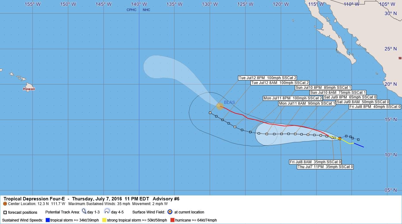
LOCATION…12.3N 111.7W
ABOUT 740 MI…1195 KM S OF THE SOUTHERN TIP OF BAJA CALIFORNIA
MAXIMUM SUSTAINED WINDS…35 MPH…55 KM/H
PRESENT MOVEMENT…W OR 270 DEGREES AT 2 MPH…4 KM/H
MINIMUM CENTRAL PRESSURE…1006 MB…29.71 INCHES
WATCHES AND WARNINGS
——————–
There are no coastal watches or warnings in effect.
DISCUSSION AND 48-HOUR OUTLOOK
——————————
At 900 PM MDT (0300 UTC), the center of Tropical Depression Four-E
was located near latitude 12.3 North, longitude 111.7 West. The
depression has been drifting westward near 2 mph (4 km/h). A
westward track with a slight increase in forward speed is
expected during the next two days.
Maximum sustained winds remain near 35 mph (55 km/h) with higher
gusts. The depression is forecast to become a tropical storm
before the weekend begins.
The estimated minimum central pressure is 1006 mb (29.71 inches).
HAZARDS AFFECTING LAND
———————-
None.
NEXT ADVISORY
————-
Next complete advisory at 300 AM MDT.
$$
Forecaster Avila
000
WTPZ44 KNHC 080233
TCDEP4
TROPICAL DEPRESSION FOUR-E DISCUSSION NUMBER 6
NWS NATIONAL HURRICANE CENTER MIAMI FL EP042016
900 PM MDT THU JUL 07 2016
Satellite imagery indicate that the low-level circulation associated
with the depression has become larger and better defined, however
the convection near the center is minimal. Most of the thunderstorm
activity is occurring in bands well to the north and southeast of
the center. There are no reasons to change the initial intensity of
30 kt, and this estimate is probably on the high side since the
Dvorak T-numbers are steady or lower tonight.
The depression has failed to strengthen likely due to the upwelling
left by Hurricane Blas, and this possibility has been taken into
consideration in previous NHC forecasts. Since most of the other
environmental parameters are favorable for intensification, the NHC
forecast still calls for such a process to begin on Friday. More
significant strengthening is anticipated beyond 48 hours, although
the NHC forecast is not as aggressive as the SHIPS models.
The overall circulation has been moving very little, and in fact it
has been drifting westward at only 2 kt. This could be the result
of the center rotating around a larger circulation. Nevertheless,
the cyclone is south of a strong subtropical ridge which is forecast
to amplify by most of the global models. This forecast pattern
favors a faster westward motion for the next 3 to 4 days with a
gradual turn to the west-northwest as the system reaches the
southwestern edge of the ridge. The NHC forecast is not very
different from the previous one, and deviates very little from the
multi-model consensus.
FORECAST POSITIONS AND MAX WINDS
INIT 08/0300Z 12.3N 111.7W 30 KT 35 MPH
12H 08/1200Z 12.5N 112.8W 30 KT 35 MPH
24H 09/0000Z 12.8N 114.4W 35 KT 40 MPH
36H 09/1200Z 12.9N 116.2W 45 KT 50 MPH
48H 10/0000Z 13.0N 118.0W 55 KT 65 MPH
72H 11/0000Z 13.0N 122.0W 75 KT 85 MPH
96H 12/0000Z 14.0N 126.5W 85 KT 100 MPH
120H 13/0000Z 16.0N 130.0W 85 KT 100 MPH
$$
Forecaster Avila


Leave a Reply