000
WTPZ33 KNHC 080232
TCPEP3
BULLETIN
HURRICANE BLAS ADVISORY NUMBER 21
NWS NATIONAL HURRICANE CENTER MIAMI FL EP032016
800 PM PDT THU JUL 07 2016
…BLAS WEAKENS TO A CATEGORY TWO HURRICANE…
SUMMARY OF 800 PM PDT…0300 UTC…INFORMATION
———————————————-
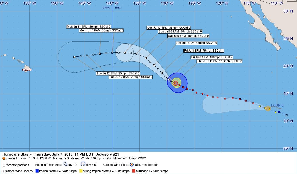
LOCATION…16.9N 128.6W
ABOUT 1280 MI…2060 KM WSW OF THE SOUTHERN TIP OF BAJA CALIFORNIA
MAXIMUM SUSTAINED WINDS…110 MPH…175 KM/H
PRESENT MOVEMENT…WNW OR 295 DEGREES AT 9 MPH…15 KM/H
MINIMUM CENTRAL PRESSURE…968 MB…28.59 INCHES
WATCHES AND WARNINGS
——————–
There are no coastal watches or warnings in effect.
DISCUSSION AND 48-HOUR OUTLOOK
——————————
At 800 PM PDT (0300 UTC), the center of Hurricane Blas was located
near latitude 16.9 North, longitude 128.6 West. Blas is moving
toward the west-northwest near 9 mph (15 km/h), and this motion is
expected to continue through tonight. A turn toward the northwest
is forecast on Friday.
Maximum sustained winds have decreased to near 110 mph (175 km/h)
with higher gusts. Blas is a category 2 hurricane on the
Saffir-Simpson Hurricane Wind Scale. Further weakening is forecast
during the next 48 hours, and Blas is expected to weaken to a
tropical storm Friday night.
Hurricane-force winds extend outward up to 35 miles (55 km) from the
center and tropical-storm-force winds extend outward up to 150 miles
(240 km).
The estimated minimum central pressure is 968 mb (28.59 inches).
HAZARDS AFFECTING LAND
———————-
None.
NEXT ADVISORY
————-
Next complete advisory at 200 AM PDT.
$$
Forecaster Roberts
000
WTPZ43 KNHC 080233
TCDEP3
HURRICANE BLAS DISCUSSION NUMBER 21
NWS NATIONAL HURRICANE CENTER MIAMI FL EP032016
800 PM PDT THU JUL 07 2016
The eye feature has become less discernible in enhanced
infrared imagery this evening, and the inner core cloud top
temperatures have warmed considerably. A compromise of all
available subjective and objective Dvorak intensity estimates
yields an initial intensity of 95 kt. Blas is expected to
accelerate its spin down as the cyclone continues to traverse a
rather sharp sea surface temperature gradient and reaches sub-24C
waters by the 36 hour period. Blas is forecast to weaken to
a tropical storm by that time, and ultimately become a remnant low
in 3 days, or earlier. The official forecast intensity is
basically an update of the previous advisory and is close to the
Florida State Superensemble.
The initial motion is west-northwestward or 295/8, within the
southwestern peripheral steering flow of a mid-level ridge
originating over eastern Mexico. Large-scale models all show the
cyclone gradually turning northwestward in 12 hours as Blas
enters a growing weakness produced by a large cut-off low northeast
of the Hawaiian Islands. As the weakening trend accelerates and
Blas becomes a vertically shallower system, the post-tropical
remnant low is expected to turn westward in the easterly flow of the
trades. The NHC forecast is based on a blend of the previous
forecast and a consensus of the ECMWF and GFS (GFEX).
FORECAST POSITIONS AND MAX WINDS
INIT 08/0300Z 16.9N 128.6W 95 KT 110 MPH
12H 08/1200Z 17.6N 129.7W 85 KT 100 MPH
24H 09/0000Z 18.8N 131.0W 65 KT 75 MPH
36H 09/1200Z 20.2N 132.4W 55 KT 65 MPH
48H 10/0000Z 21.5N 133.9W 40 KT 45 MPH
72H 11/0000Z 22.5N 137.7W 30 KT 35 MPH…POST-TROP/REMNT LOW
96H 12/0000Z 22.3N 142.3W 25 KT 30 MPH…POST-TROP/REMNT LOW
120H 13/0000Z 21.7N 146.9W 20 KT 25 MPH…POST-TROP/REMNT LOW
$$
Forecaster Roberts


Leave a Reply