000
WTPZ33 KNHC 090232
TCPEP3
BULLETIN
HURRICANE BLAS ADVISORY NUMBER 25
NWS NATIONAL HURRICANE CENTER MIAMI FL EP032016
800 PM PDT FRI JUL 08 2016
…BLAS DECAYING OVER COOL WATERS…
SUMMARY OF 800 PM PDT…0300 UTC…INFORMATION
———————————————-
LOCATION…19.2N 131.0W
ABOUT 1380 MI…2225 KM W OF THE SOUTHERN TIP OF BAJA CALIFORNIA
MAXIMUM SUSTAINED WINDS…80 MPH…130 KM/H
PRESENT MOVEMENT…NW OR 325 DEGREES AT 12 MPH…19 KM/H
MINIMUM CENTRAL PRESSURE…985 MB…29.09 INCHES
WATCHES AND WARNINGS
——————–
There are no coastal watches or warnings in effect.
DISCUSSION AND 48-HOUR OUTLOOK
——————————
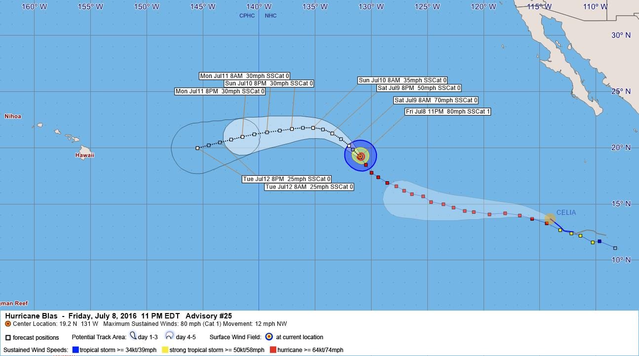
At 800 PM PDT (0300 UTC), the center of Hurricane Blas was located
near latitude 19.2 North, longitude 131.0 West. Blas is moving
toward the northwest near 12 mph (19 km/h), and this motion is
expected to continue for the next 24 hours. A gradual turn
to the west is anticipated thereafter.
Maximum sustained winds have decreased to near 80 mph (130 km/h)
with higher gusts. Weakening is forecast, and Blas is expected
to degenerate into a remnant low on Sunday.
Hurricane-force winds extend outward up to 30 miles (45 km) from the
center, and tropical-storm-force winds extend outward up to 105
miles (165 km).
The estimated minimum central pressure is 985 mb (29.09 inches).
HAZARDS AFFECTING LAND
———————-
None.
NEXT ADVISORY
————-
Next complete advisory at 200 AM PDT.
$$
Forecaster Avila
000
WTPZ43 KNHC 090233
TCDEP3
HURRICANE BLAS DISCUSSION NUMBER 25
NWS NATIONAL HURRICANE CENTER MIAMI FL EP032016
800 PM PDT FRI JUL 08 2016
Blas has continued to move over increasingly cooler waters, and
although the convection has been on a general weakening trend, the
hurricane still has a vigorous circulation as indicated by ASCAT
earlier today. A blend of subjective and objective Dvorak numbers
from all agencies supports an initial intensity of 70 kt. In
addition to the effect of cooler waters, the shear is forecast to
increase. Recent microwave imagery suggests that the low-level
center is south of the convection, indicating that the shear is
already increasing. These factors should result in faster
weakening, and Blas is expected to become a remnant low by Sunday or
sooner. In fact, SHIPS and LGEM basically dissipate the cyclone
in 48 hours or so.
The cyclone is moving toward the northwest or 325 degrees at about
10 kt around the southwestern periphery of the Pacific subtropical
ridge, and this general track is forecast to continue for a day or
so. In about 36 hours or less, Blas should have become a shallow
system and will likely be steered westward and west-southwestward by
the low-level trade winds. Most of the models have been fairly
consistent with this scenario for a while, and there are no obvious
reasons to vary from earlier NHC forecasts.
FORECAST POSITIONS AND MAX WINDS
INIT 09/0300Z 19.2N 131.0W 70 KT 80 MPH
12H 09/1200Z 20.2N 132.0W 60 KT 70 MPH
24H 10/0000Z 21.3N 133.5W 45 KT 50 MPH
36H 10/1200Z 21.8N 135.2W 30 KT 35 MPH…POST-TROP/REMNT LOW
48H 11/0000Z 21.7N 137.1W 25 KT 30 MPH…POST-TROP/REMNT LOW
72H 12/0000Z 21.0N 141.5W 25 KT 30 MPH…POST-TROP/REMNT LOW
96H 13/0000Z 20.0N 145.5W 20 KT 25 MPH…POST-TROP/REMNT LOW
120H 14/0000Z…DISSIPATED
$$
Forecaster Avila


Leave a Reply