000
WTPZ34 KNHC 090234
TCPEP4
BULLETIN
TROPICAL STORM CELIA ADVISORY NUMBER 10
NWS NATIONAL HURRICANE CENTER MIAMI FL EP042016
900 PM MDT FRI JUL 08 2016
…COLD WATER LEFT BEHIND BY HURRICANE BLAS LIKELY KEEPING CELIA
FROM STRENGTHENING…
SUMMARY OF 900 PM MDT…0300 UTC…INFORMATION
———————————————-
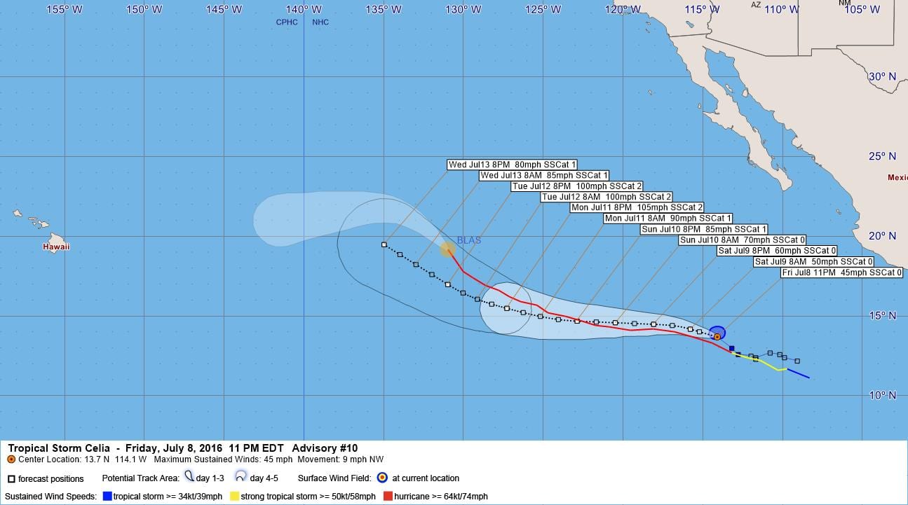
LOCATION…13.7N 114.1W
ABOUT 690 MI…1115 KM SSW OF THE SOUTHERN TIP OF BAJA CALIFORNIA
MAXIMUM SUSTAINED WINDS…45 MPH…75 KM/H
PRESENT MOVEMENT…NW OR 305 DEGREES AT 9 MPH…15 KM/H
MINIMUM CENTRAL PRESSURE…1003 MB…29.62 INCHES
WATCHES AND WARNINGS
——————–
There are no coastal watches or warnings in effect.
DISCUSSION AND 48-HOUR OUTLOOK
——————————
At 900 PM MDT (0300 UTC), the center of Tropical Storm Celia was
located near latitude 13.7 North, longitude 114.1 West. Celia is
moving toward the northwest near 9 mph (15 km/h). A turn toward
the west-northwest at a faster forward speed is expected later
tonight, followed by a westward turn late Saturday.
Maximum sustained winds remain near 45 mph (75 km/h) with higher
gusts. Gradual strengthening is forecast through Saturday,
followed by faster strengthening thereafter. Celia could become a
hurricane on Sunday.
Tropical-storm-force winds extend outward up to 45 miles (75 km)
to the north of the center.
The estimated minimum central pressure is 1003 mb (29.62 inches).
HAZARDS AFFECTING LAND
———————-
None.
NEXT ADVISORY
————-
Next complete advisory at 300 AM MDT.
$$
Forecaster Berg
000
WTPZ44 KNHC 090235
TCDEP4
TROPICAL STORM CELIA DISCUSSION NUMBER 10
NWS NATIONAL HURRICANE CENTER MIAMI FL EP042016
900 PM MDT FRI JUL 08 2016
Visible satellite imagery shows that Celia has an expansive cloud
shield, with a compact CDO feature and multiple elongated cloud
bands. However, deep convection is disjointed and fairly limited
near the low-level center. Dvorak intensity estimates from TAFB
and SAB are unchanged from six hours ago, and the CIMSS ADT
estimate has actually decreased during that time. Therefore, the
initial intensity is left at 40 kt.
Celia’s center temporarily moved northward earlier today, but the
average motion over the past 12 hours is estimated to be
northwestward, or 305/8 kt. A subtropical ridge extending westward
from northern Mexico should cause Celia to resume a west-
northwestward to westward motion but at a faster forward speed
through day 3. The cyclone is expected to reach the southwestern
periphery of the ridge by day 4, which should cause Celia to turn
northwestward by the end of the forecast period. The track model
spread is low, especially through day 3, and the NHC track forecast
is very close to the various consensus models. This updated
forecast is a little north of the previous one during the first 24
hours to account for Celia’s recent northward jog.
High-resolution microwave SST data indicate that Celia’s center is
now moving over the coldest portion of Blas’s cold wake, which could
be contributing to the relative lack of central deep convection.
Celia will continue moving over the cold wake for another day or
so, and only gradual strengthening is anticipated in the short
term. Warmer waters and low shear should allow faster
intensification to begin in 36-48 hours, with Celia likely
reaching its peak intensity in about 3 days. Cooler waters should
then induce a gradual weakening trend on days 4 and 5. In light of
the latest guidance, no significant changes were made to the
previous NHC intensity forecast.
FORECAST POSITIONS AND MAX WINDS
INIT 09/0300Z 13.7N 114.1W 40 KT 45 MPH
12H 09/1200Z 14.2N 115.8W 45 KT 50 MPH
24H 10/0000Z 14.5N 118.1W 50 KT 60 MPH
36H 10/1200Z 14.6N 120.5W 60 KT 70 MPH
48H 11/0000Z 14.7N 122.9W 75 KT 85 MPH
72H 12/0000Z 15.5N 127.3W 90 KT 105 MPH
96H 13/0000Z 17.0N 131.0W 85 KT 100 MPH
120H 14/0000Z 19.5N 135.0W 70 KT 80 MPH
$$
Forecaster Berg


Leave a Reply