000
WTPZ34 KNHC 110832
TCPEP4
BULLETIN
HURRICANE CELIA ADVISORY NUMBER 19
NWS NATIONAL HURRICANE CENTER MIAMI FL EP042016
200 AM PDT MON JUL 11 2016
…CELIA A LITTLE STRONGER AS IT CONTINUES MOVING WESTWARD…
SUMMARY OF 200 AM PDT…0900 UTC…INFORMATION
———————————————-
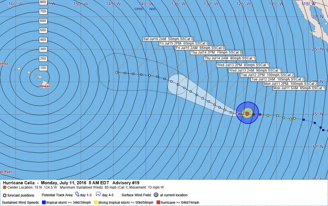
LOCATION…15.0N 124.5W
ABOUT 1095 MI…1765 KM WSW OF THE SOUTHERN TIP OF BAJA CALIFORNIA
MAXIMUM SUSTAINED WINDS…85 MPH…140 KM/H
PRESENT MOVEMENT…W OR 270 DEGREES AT 13 MPH…20 KM/H
MINIMUM CENTRAL PRESSURE…983 MB…29.03 INCHES
WATCHES AND WARNINGS
——————–
There are no coastal watches or warnings in effect.
DISCUSSION AND 48-HOUR OUTLOOK
——————————
At 200 AM PDT (0900 UTC), the center of Hurricane Celia was located
near latitude 15.0 North, longitude 124.5 West. Celia is moving
toward the west near 13 mph (20 km/h), and this motion is expected
to continue today. A turn toward the west-northwest with a slight
decrease in forward speed is forecast tonight.
Maximum sustained winds have increased to near 85 mph (140 km/h)
with higher gusts. Some additional strengthening is expected during
the next day or so. Slow weakening is forecast to begin on Tuesday.
Hurricane-force winds extend outward up to 30 miles (45 km) from the
center and tropical-storm-force winds extend outward up to 140 miles
(220 km).
The estimated minimum central pressure is 983 mb (29.03 inches).
HAZARDS AFFECTING LAND
———————-
None.
NEXT ADVISORY
————-
Next complete advisory at 800 AM PDT.
$$
Forecaster Brennan
000
WTPZ44 KNHC 110833
TCDEP4
HURRICANE CELIA DISCUSSION NUMBER 19
NWS NATIONAL HURRICANE CENTER MIAMI FL EP042016
200 AM PDT MON JUL 11 2016
Celia still has a somewhat ragged satellite appearance tonight. The
deepest convection is located in a broken ring around a ragged
intermittent eye and in a band well east of the center. TAFB and
SAB Dvorak estimates at 06Z were T4.5/77 kt, and the initial
intensity is set to 75 kt for this advisory. Additional slow
strengthening seems likely for the next day or so while Celia moves
over SSTs above 26C. After that time the waters will cool, which
should result in a slow weakening through the remainder of the
forecast period since the shear will remain low. The new NHC
forecast is similar to the previous one, showing a peak of 90 kt in
about 24 h, and this is above all of the intensity guidance. During
the weakening phase, the NHC forecast lies between the stronger
SHIPS model and the weaker LGEM.
The hurricane is moving westward at 11 kt. A turn toward the
west-northwest is forecast in about 24 hours as Celia reaches the
southwestern edge of a mid-level ridge. By the end of the period,
the ridge should rebuild to the north, resulting in the track
bending back toward the west. Overall, the track model guidance is
in good agreement on this scenario. For this cycle, the NHC
forecast has been adjusted a bit to the north, but lies south of the
latest TVCN multi-model consensus aid.
An ASCAT-B pass from around 0520Z was used to adjust the initial
34-kt and 50-kt wind radii.
FORECAST POSITIONS AND MAX WINDS
INIT 11/0900Z 15.0N 124.5W 75 KT 85 MPH
12H 11/1800Z 15.1N 126.0W 85 KT 100 MPH
24H 12/0600Z 15.7N 127.9W 90 KT 105 MPH
36H 12/1800Z 16.5N 129.5W 85 KT 100 MPH
48H 13/0600Z 17.5N 131.3W 80 KT 90 MPH
72H 14/0600Z 19.6N 135.1W 70 KT 80 MPH
96H 15/0600Z 21.0N 139.5W 55 KT 65 MPH
120H 16/0600Z 21.5N 144.5W 45 KT 50 MPH
$$
Forecaster Brennan


Leave a Reply