000
WTPZ34 KNHC 120242
TCPEP4
BULLETIN
HURRICANE CELIA ADVISORY NUMBER 22
NWS NATIONAL HURRICANE CENTER MIAMI FL EP042016
800 PM PDT MON JUL 11 2016
…CELIA PROBABLY AT PEAK INTENSITY…
…SHOULD BEGIN WEAKENING TOMORROW…
SUMMARY OF 800 PM PDT…0300 UTC…INFORMATION
———————————————-
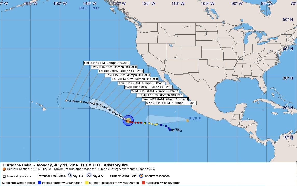
LOCATION…15.5N 127.0W
ABOUT 1225 MI…1970 KM WSW OF THE SOUTHERN TIP OF BAJA CALIFORNIA
MAXIMUM SUSTAINED WINDS…100 MPH…155 KM/H
PRESENT MOVEMENT…WNW OR 285 DEGREES AT 10 MPH…17 KM/H
MINIMUM CENTRAL PRESSURE…972 MB…28.71 INCHES
WATCHES AND WARNINGS
——————–
There are no coastal watches or warnings in effect.
DISCUSSION AND 48-HOUR OUTLOOK
——————————
At 800 PM PDT (0300 UTC), the center of Hurricane Celia was located
near latitude 15.5 North, longitude 127.0 West. Celia is moving
toward the west-northwest near 10 mph (17 km/h), and a
west-northwestward or northwestward motion is expected over the
next 48 hours.
Maximum sustained winds remain near 100 mph (155 km/h) with higher
gusts. A gradual weakening trend is likely to begin on Tuesday.
Hurricane-force winds extend outward up to 30 miles (45 km) from the
center and tropical-storm-force winds extend outward up to 140 miles
(220 km).
The estimated minimum central pressure is 972 mb (28.71 inches).
HAZARDS AFFECTING LAND
———————-
None.
NEXT ADVISORY
————-
Next complete advisory at 200 AM PDT.
$$
Forecaster Pasch
000
WTPZ44 KNHC 120244
TCDEP4
HURRICANE CELIA DISCUSSION NUMBER 22
NWS NATIONAL HURRICANE CENTER MIAMI FL EP042016
800 PM PDT MON JUL 11 2016
Celia continues to lack a definitive Central Dense Overcast and the
central features look rather ragged in conventional geostationary
imagery. A 37 GHz SSM/I image from a few hours ago revealed that
the eye was open over the northeast quadrant. The current intensity
estimate is kept at 85 kt, which is a blend of subjective Dvorak
estimates from TAFB and SAB and UW-CIMSS ADT estimates. Since
Celia should be moving over waters that will be gradually cooling
and into a more stable air mass, a weakening trend will commence
soon. The official intensity forecast is very close to the latest
model consensus, IVCN.
The cyclone has turned toward the west-northwest and the motion is
now about 285/9 kt. Celia is near the western periphery of a
mid-tropospheric subtropical ridge, and a west-northwestward to
northwestward motion is likely for the next couple of days. A
mid-level cyclone currently to the northeast of the Hawaiian
Islands is predicted to open up into a trough and lift northward,
allowing a ridge to build back in to the north of the tropical
cyclone. This evolution of the steering pattern should cause Celia
to turn more toward the west in the latter part of the forecast
period. The track models have mostly shifted northward from
their previous predictions, so the official forecast has been nudged
a little to the north of the previous one. This is south of the
latest dynamical model consensus, however.
FORECAST POSITIONS AND MAX WINDS
INIT 12/0300Z 15.5N 127.0W 85 KT 100 MPH
12H 12/1200Z 16.2N 128.3W 80 KT 90 MPH
24H 13/0000Z 17.4N 130.1W 75 KT 85 MPH
36H 13/1200Z 18.6N 132.0W 65 KT 75 MPH
48H 14/0000Z 19.8N 134.1W 55 KT 65 MPH
72H 15/0000Z 21.4N 138.6W 45 KT 50 MPH
96H 16/0000Z 22.0N 143.0W 35 KT 40 MPH
120H 17/0000Z 22.5N 148.0W 30 KT 35 MPH
$$
Forecaster Pasch


Leave a Reply