000
WTPZ35 KNHC 152032
TCPEP5
BULLETIN
HURRICANE DARBY ADVISORY NUMBER 17
NWS NATIONAL HURRICANE CENTER MIAMI FL EP052016
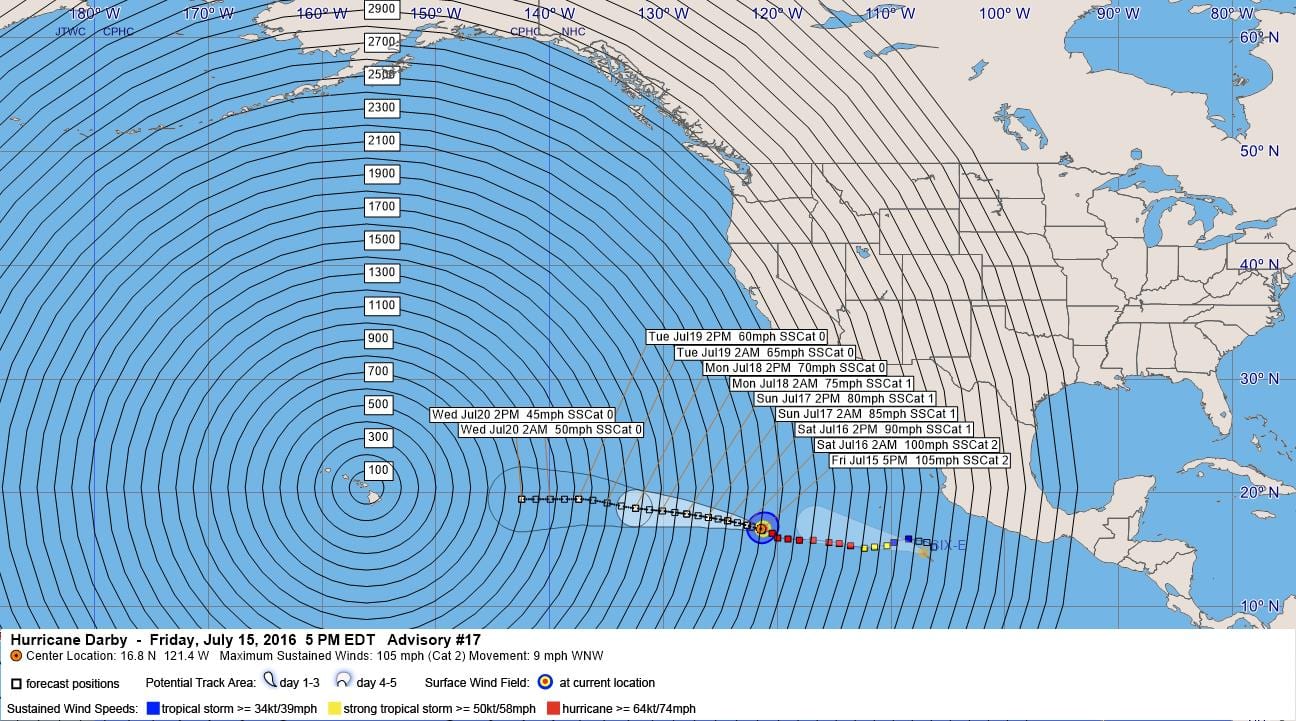
200 PM PDT FRI JUL 15 2016
…DARBY A LITTLE STRONGER…
SUMMARY OF 200 PM PDT…2100 UTC…INFORMATION
———————————————-
LOCATION…16.8N 121.4W
ABOUT 855 MI…1380 KM WSW OF THE SOUTHERN TIP OF BAJA CALIFORNIA
MAXIMUM SUSTAINED WINDS…105 MPH…165 KM/H
PRESENT MOVEMENT…WNW OR 290 DEGREES AT 9 MPH…15 KM/H
MINIMUM CENTRAL PRESSURE…972 MB…28.71 INCHES
WATCHES AND WARNINGS
——————–
There are no coastal watches or warnings in effect.
DISCUSSION AND 48-HOUR OUTLOOK
——————————
At 200 PM PDT (2100 UTC), the eye of Hurricane Darby was located
near latitude 16.8 North, longitude 121.4 West. Darby is moving
toward the west-northwest near 9 mph (15 km/h), and this general
motion is expected to continue for the next couple of days.
Maximum sustained winds have increased to near 105 mph (165 km/h)
with higher gusts. Some weakening is forecast during the next 48
hours.
Hurricane-force winds extend outward up to 35 miles (55 km) from the
center, and tropical-storm-force winds extend outward up to 115
miles (185 km).
The estimated minimum central pressure is 972 mb (28.71 inches).
HAZARDS AFFECTING LAND
———————-
None.
NEXT ADVISORY
————-
Next complete advisory at 800 PM PDT.
$$
Forecaster Berg
000
WTPZ45 KNHC 152033
TCDEP5
HURRICANE DARBY DISCUSSION NUMBER 17
NWS NATIONAL HURRICANE CENTER MIAMI FL EP052016
200 PM PDT FRI JUL 15 2016
Darby’s eye has been clearing out during the past few hours with
some warming noted in infrared satellite imagery. There are some
breaks in the surrounding convection due to infiltration of dry
air, which has caused the subjective data-T numbers to oscillate
around 4.5 and 5.0 since this morning. However, CI numbers are 5.0
from both TAFB and SAB, and ADT estimates are up to 5.3/97 kt. Based
on these data, Darby’s maximum winds are increased to 90 kt.
Vertical shear over Darby has become quite low and should remain low
during the entire forecast period. However, based on the latest
global SST analysis, Darby will only be over waters warmer than
26.5C for another 12-18 hours and is likely to reach SSTs as cold as
24C in a couple of days. Therefore, additional significant
strengthening is not anticipated, and in fact, a gradual weakening
trend is shown in the official forecast for the entire five days.
This forecast is very similar to the previous one and remains
relatively close to the SHIPS guidance and the Florida State
Superensemble.
The hurricane is moving west-northwestward, or 290/8 kt, to the
south of a strong mid-level ridge extending west of northern
Mexico. The ridge is forecast to weaken during the next 24 hours
due to an amplifying mid- to upper-level trough along the west
coast of the United States. This should keep Darby moving
west-northwestward for the next few days, followed by a turn to the
west at the end of the forecast period once the weaker cyclone
becomes steered by lower-level steering flow. It may sound like a
broken record, but the track guidance remains tightly clustered for
the entire forecast period. The updated NHC forecast is
essentially down the middle of the guidance envelope and not too
much different from the previous forecast.
FORECAST POSITIONS AND MAX WINDS
INIT 15/2100Z 16.8N 121.4W 90 KT 105 MPH
12H 16/0600Z 17.2N 122.7W 85 KT 100 MPH
24H 16/1800Z 17.6N 124.4W 80 KT 90 MPH
36H 17/0600Z 17.9N 126.1W 75 KT 85 MPH
48H 17/1800Z 18.2N 128.0W 70 KT 80 MPH
72H 18/1800Z 18.7N 132.5W 60 KT 70 MPH
96H 19/1800Z 19.5N 137.5W 50 KT 60 MPH
120H 20/1800Z 19.5N 142.5W 40 KT 45 MPH
$$
Forecaster Berg


Leave a Reply