000
WTPZ31 KNHC 152037
TCPEP1
BULLETIN
TROPICAL DEPRESSION SIX-E ADVISORY NUMBER 2
NWS NATIONAL HURRICANE CENTER MIAMI FL EP062016
300 PM MDT FRI JUL 15 2016
…TROPICAL DEPRESSION EXPECTED TO STRENGTHEN…
SUMMARY OF 300 PM MDT…2100 UTC…INFORMATION
———————————————-
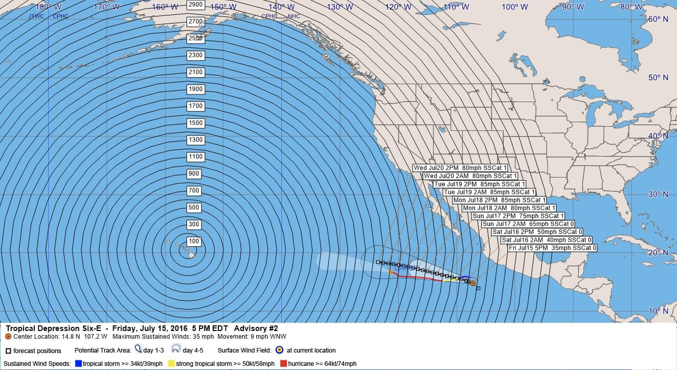
LOCATION…14.8N 107.2W
ABOUT 350 MI…560 KM SW OF MANZANILLO MEXICO
MAXIMUM SUSTAINED WINDS…35 MPH…55 KM/H
PRESENT MOVEMENT…WNW OR 295 DEGREES AT 9 MPH…15 KM/H
MINIMUM CENTRAL PRESSURE…1007 MB…29.74 INCHES
WATCHES AND WARNINGS
——————–
There are no coastal watches or warnings in effect.
DISCUSSION AND 48-HOUR OUTLOOK
——————————
At 300 PM MDT (2100 UTC), the center of Tropical Depression Six-E
was located near latitude 14.8 North, longitude 107.2 West. The
depression is moving toward the west-northwest near 9 mph (15 km/h),
and this motion is expected to continue over the next couple of
days.
Maximum sustained winds are near 35 mph (55 km/h) with higher gusts.
Strengthening is expected during the next 48 hours, and the
depression is forecast to become a tropical storm tonight or
early Saturday.
The estimated minimum central pressure is 1007 mb (29.74 inches).
HAZARDS AFFECTING LAND
———————-
None
NEXT ADVISORY
————-
Next complete advisory at 900 PM MDT.
$$
Forecaster Brown
000
WTPZ41 KNHC 152037
TCDEP1
TROPICAL DEPRESSION SIX-E DISCUSSION NUMBER 2
NWS NATIONAL HURRICANE CENTER MIAMI FL EP062016
300 PM MDT FRI JUL 15 2016
Visible satellite images show that the tropical depression still
lacks inner-core convection, but several curved bands are noted
over the southwestern and northern portions of the large
circulation. Dvorak T-numbers were 2.0 from both TAFB and SAB,
and a recent ASCAT overpass revealed peak winds of 25 to 30 kt.
These data support an initial wind speed of 30 kt for this
advisory. The forecast track of the depression keeps it over sea
surface temperatures above 28C for the next couple of days, and the
upper-level environment is also favorable for strengthening.
Intensification is predicted, but it may be gradual through tonight
due to the depression’s large size and lack of an inner core.
Steady strengthening is likely on Saturday and Sunday, and the
system is forecast to become a hurricane in about 48 hours, which is
in good agreement with the SHIPS guidance. In 3 to 4 days, the
forecast track takes the tropical cyclone over waters that have been
cooled by the past couple of hurricanes. This should result in a
leveling off of the intensity, followed by gradual weakening near
the end of the forecast period when the cyclone encounters even
cooler water.
The depression is moving west-northwestward or 295/8 kt. There has
been no change to the track forecast reasoning. The cyclone is
expected to continue moving west-northwestward for nearly all of
the forecast period to the southwest of a strong mid- to upper-level
ridge that extends westward from northern Mexico. The track
guidance remains in generally good agreement throughout the forecast
period. The NHC track has been nudged northward, primarily
due to a small northward relocation of the center, but otherwise
the new track forecast is essentially an update of the previous
advisory.
FORECAST POSITIONS AND MAX WINDS
INIT 15/2100Z 14.8N 107.2W 30 KT 35 MPH
12H 16/0600Z 15.3N 108.4W 35 KT 40 MPH
24H 16/1800Z 15.7N 110.0W 45 KT 50 MPH
36H 17/0600Z 16.1N 111.7W 55 KT 65 MPH
48H 17/1800Z 16.5N 113.4W 65 KT 75 MPH
72H 18/1800Z 17.3N 116.7W 75 KT 85 MPH
96H 19/1800Z 18.0N 120.0W 75 KT 85 MPH
120H 20/1800Z 18.5N 123.5W 70 KT 80 MPH
$$
Forecaster Brown


Leave a Reply