000
WTPZ35 KNHC 180235
TCPEP5
BULLETIN
HURRICANE DARBY ADVISORY NUMBER 26
NWS NATIONAL HURRICANE CENTER MIAMI FL EP052016
800 PM PDT SUN JUL 17 2016
…DARBY MAINTAINING STRENGTH FOR NOW…
…STILL LIKELY TO WEAKEN…
SUMMARY OF 800 PM PDT…0300 UTC…INFORMATION
———————————————-
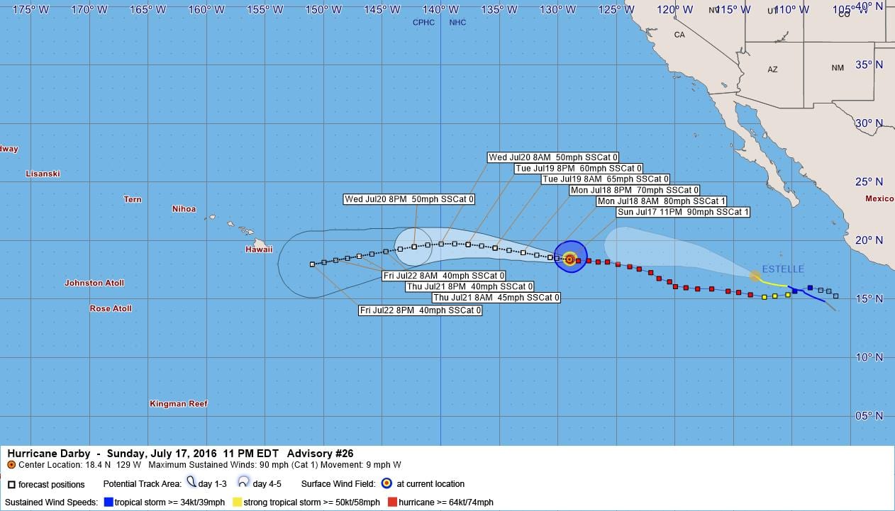
LOCATION…18.4N 129.0W
ABOUT 1270 MI…2045 KM W OF THE SOUTHERN TIP OF BAJA CALIFORNIA
MAXIMUM SUSTAINED WINDS…90 MPH…150 KM/H
PRESENT MOVEMENT…W OR 275 DEGREES AT 9 MPH…15 KM/H
MINIMUM CENTRAL PRESSURE…978 MB…28.88 INCHES
WATCHES AND WARNINGS
——————–
There are no coastal watches or warnings in effect.
DISCUSSION AND 48-HOUR OUTLOOK
——————————
At 800 PM PDT (0300 UTC), the center of Hurricane Darby was located
near latitude 18.4 North, longitude 129.0 West. Darby is moving
toward the west near 9 mph (15 km/h), and a generally westward
motion at a slightly faster forward speed is expected over the next
48 hours.
Maximum sustained winds remain near 90 mph (150 km/h) with higher
gusts. Weakening is forecast during the next 48 hours, and Darby
should become a tropical storm in a day or so.
Hurricane-force winds extend outward up to 30 miles (45 km) from the
center and tropical-storm-force winds extend outward up to 115 miles
(185 km).
The estimated minimum central pressure is 978 mb (28.88 inches).
HAZARDS AFFECTING LAND
———————-
None.
NEXT ADVISORY
————-
Next complete advisory at 200 AM PDT.
$$
Forecaster Pasch
000
WTPZ45 KNHC 180236
TCDEP5
HURRICANE DARBY DISCUSSION NUMBER 26
NWS NATIONAL HURRICANE CENTER MIAMI FL EP052016
800 PM PDT SUN JUL 17 2016
Darby has not weakened since the last advisory; in fact the
hurricane looks a little more impressive than it did earlier today.
Although central convection has not strengthened appreciably, the
CDO has become more symmetric and the eye a little more distinct.
The current intensity estimate is held at 80 kt which is close to a
consensus of Dvorak estimates from SAB and TAFB, along with ADT
estimates from UW-CIMSS. Darby is over SSTs near 24 deg C and will
be moving over slightly cooler waters overnight. After that, the
cyclone should traverse SSTs near 25 deg C through 48 hours.
Gradual weakening is predicted due to these somewhat cool waters,
and Darby should lose hurricane status in about 24 hours with
additional weakening thereafter. In 72 hours or so, the ocean under
Darby will warm slightly to 25-26 deg C but by that time the
vertical shear, which had been low, is forecast to increase and this
should prevent restrenghtening in the latter part of the forecast
period. The official intensity forecast is close to the latest
model consensus.
Darby continues on a westward track and the initial motion estimate
remains 275/8 kt. There is no reason to change the track forecast
from the previous advisory package. A narrow east-west oriented
mid-level ridge is expected to be maintained to the north of Darby
for the next several days. Late in the period, a mid-level high
builds to the northwest of the tropical cyclone which should cause
a slightly south of west motion. The official forecast lies a
little south of the dynamical model consensus and is a blend of the
latest GFS and ECMWF predictions.
FORECAST POSITIONS AND MAX WINDS
INIT 18/0300Z 18.4N 129.0W 80 KT 90 MPH
12H 18/1200Z 18.6N 130.7W 70 KT 80 MPH
24H 19/0000Z 19.0N 133.0W 60 KT 70 MPH
36H 19/1200Z 19.4N 135.4W 55 KT 65 MPH
48H 20/0000Z 19.7N 137.7W 50 KT 60 MPH
72H 21/0000Z 19.5N 142.3W 45 KT 50 MPH
96H 22/0000Z 18.7N 147.0W 35 KT 40 MPH
120H 23/0000Z 18.0N 151.0W 35 KT 40 MPH
$$
Forecaster Pasch


Leave a Reply