000
WTPZ31 KNHC 180233
TCPEP1
BULLETIN
TROPICAL STORM ESTELLE ADVISORY NUMBER 11
NWS NATIONAL HURRICANE CENTER MIAMI FL EP062016
900 PM MDT SUN JUL 17 2016
…ESTELLE FORECAST TO BECOME A HURRICANE ON MONDAY…
SUMMARY OF 900 PM MDT…0300 UTC…INFORMATION
———————————————-
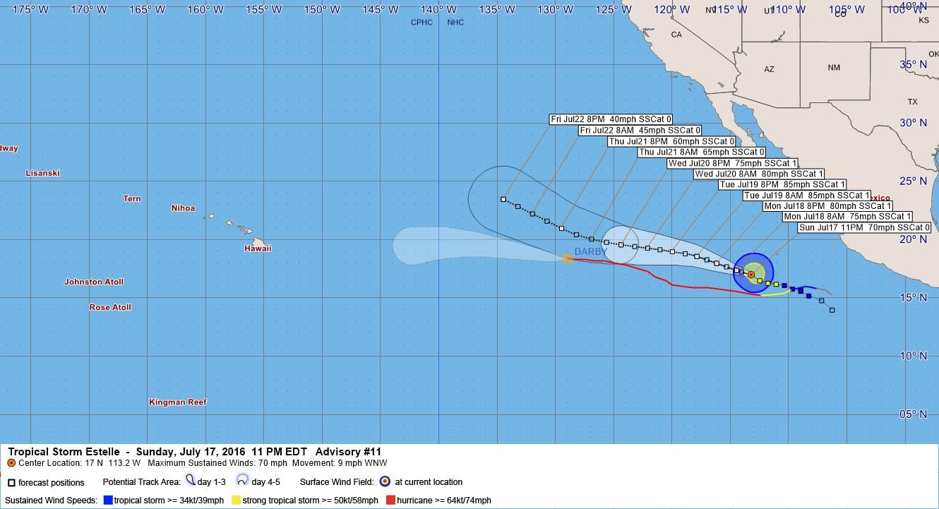
LOCATION…17.0N 113.2W
ABOUT 460 MI…740 KM SSW OF THE SOUTHERN TIP OF BAJA CALIFORNIA
MAXIMUM SUSTAINED WINDS…70 MPH…110 KM/H
PRESENT MOVEMENT…WNW OR 290 DEGREES AT 9 MPH…15 KM/H
MINIMUM CENTRAL PRESSURE…991 MB…29.27 INCHES
WATCHES AND WARNINGS
——————–
There are no coastal watches or warnings in effect.
DISCUSSION AND 48-HOUR OUTLOOK
——————————
At 900 PM MDT (0300 UTC), the center of Tropical Storm Estelle was
located near latitude 17.0 North, longitude 113.2 West. Estelle is
moving toward the west-northwest near 9 mph (15 km/h) and this
general motion is expected to continue for the next couple of days.
Maximum sustained winds remain near 70 mph (110 km/h) with higher
gusts. Strengthening is forecast during the next couple of days,
and Estelle is expected to become a hurricane on Monday.
Tropical-storm-force winds extend outward up to 140 miles (220 km)
from the center.
The estimated minimum central pressure is 991 mb (29.27 inches).
HAZARDS AFFECTING LAND
———————-
None.
NEXT ADVISORY
————-
Next complete advisory at 300 AM MDT.
$$
Forecaster Blake
000
WTPZ41 KNHC 180234
TCDEP1
TROPICAL STORM ESTELLE DISCUSSION NUMBER 11
NWS NATIONAL HURRICANE CENTER MIAMI FL EP062016
900 PM MDT SUN JUL 17 2016
Estelle looks a little less organized than this afternoon, since the
eye feature seen on previous microwave imagery has disappeared and
the tropical cyclone is displaying a more asymmetric pattern. The
initial wind speed is held at 60 kt for this advisory, a blend of
the T- and CI-numbers from TAFB/SAB. It seems like some
northwesterly shear is preventing much intensification at
this time. The shear, however, should abate during the next 24
hours, which would allow for gradual strengthening until the storm
reaches cooler water in a couple of days. Thereafter, a more steady
weakening is likely, and Estelle should become post-tropical in
about 5 days while it moves over 23 deg C waters. The models have
backed off somewhat on the peak intensity, and the official forecast
follows suit, although the new prediction is higher than the
consensus for the first few days.
Best estimate of initial motion is to the west-northwest at about 8
kt. Estelle should continue to move on that general course for the
next couple of days, with perhaps a bend toward the west in 3 days
due to the subtropical ridge to the north temporarily strengthening.
Overall, the global models are showing less ridging between 130-140W
at long range, which would cause Estelle to turn west-northwestward
or even northwestward by the end of the forecast period.
Accordingly, most of the models have again shifted northward this
cycle, and the official forecast is moved in that direction.
FORECAST POSITIONS AND MAX WINDS
INIT 18/0300Z 17.0N 113.2W 60 KT 70 MPH
12H 18/1200Z 17.4N 114.5W 65 KT 75 MPH
24H 19/0000Z 18.0N 116.2W 70 KT 80 MPH
36H 19/1200Z 18.6N 117.9W 75 KT 85 MPH
48H 20/0000Z 19.0N 120.0W 75 KT 85 MPH
72H 21/0000Z 19.6N 124.4W 65 KT 75 MPH
96H 22/0000Z 21.0N 129.5W 50 KT 60 MPH
120H 23/0000Z 23.5N 134.5W 35 KT 40 MPH…POST-TROPICAL
$$
Forecaster Blake


Leave a Reply