000
WTPA31 PHFO 012044
TCPCP1
BULLETIN
Hurricane Erick Advisory Number 22
NWS Central Pacific Hurricane Center Honolulu HI EP062019
1100 AM HST Thu Aug 01 2019
…ERICK STILL HANGING ON AS A HURRICANE…
SUMMARY OF 1100 AM HST…2100 UTC…INFORMATION
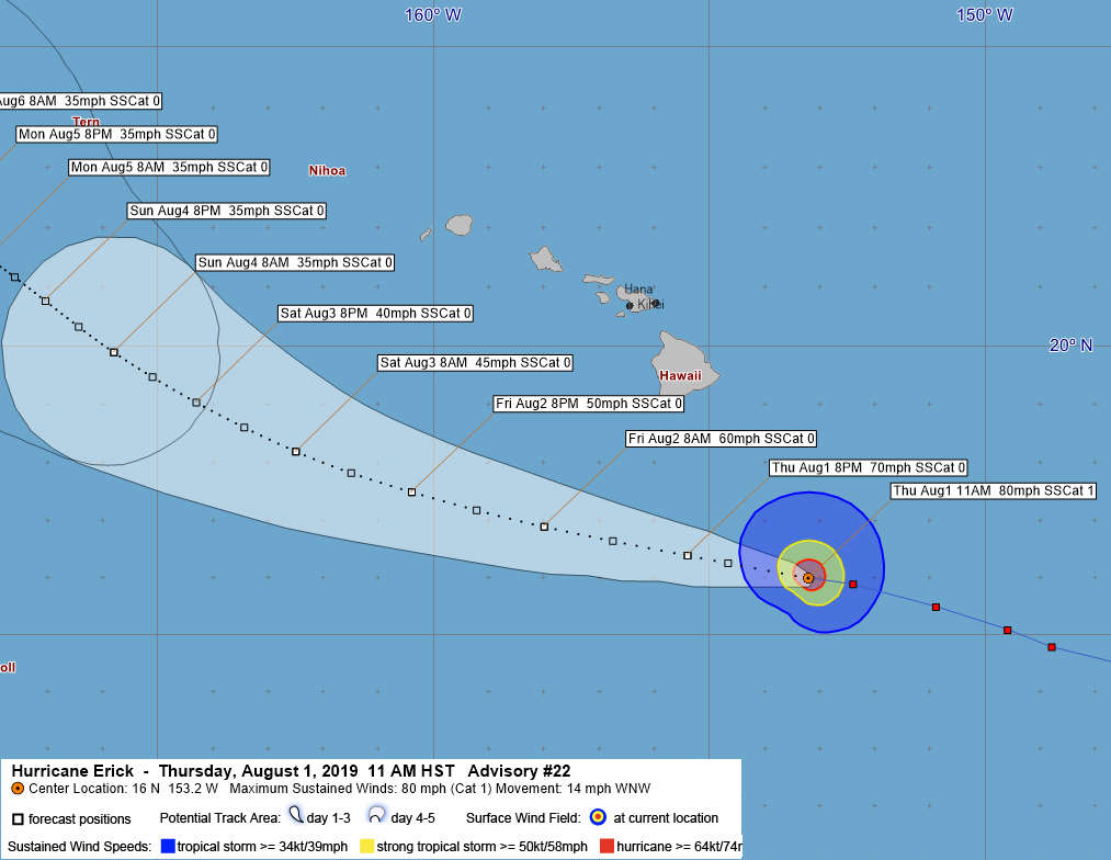
LOCATION…16.0N 153.2W
ABOUT 285 MI…460 KM SSE OF HILO HAWAII
ABOUT 480 MI…770 KM SE OF HONOLULU HAWAII
MAXIMUM SUSTAINED WINDS…80 MPH…130 KM/H
PRESENT MOVEMENT…WNW OR 285 DEGREES AT 14 MPH…22 KM/H
MINIMUM CENTRAL PRESSURE…985 MB…29.09 INCHES
WATCHES AND WARNINGS
There are no coastal watches or warnings in effect.
DISCUSSION AND OUTLOOK
At 1100 AM HST (2100 UTC), the center of Hurricane Erick was located
near latitude 16.0 North, longitude 153.2 West. Erick is moving
toward the west-northwest near 14 mph (22 km/h), and this motion is
expected to continue over the next couple of days. On the forecast
track, the center of Erick will pass within about 200 miles
south of the Big Island of Hawaii later today and tonight.
Maximum sustained winds are near 80 mph (130 km/h) with higher
gusts. Significant weakening is forecast during the next couple of
days, and Erick is expected to weaken to a tropical storm later
today or tonight.
Hurricane-force winds extend outward up to 25 miles (35 km) from the
center and tropical-storm-force winds extend outward up to 105 miles
(165 km).
The estimated minimum central pressure is 985 mb (29.09 inches).
HAZARDS AFFECTING LAND
SURF: Swells generated by Erick will build across the Hawaiian
Islands today and persist across some areas through Friday,
potentially producing dangerous surf conditions, mainly along east
and southeast facing shores.
RAINFALL: Moisture associated with Erick will spread over portions
of the Hawaiian Islands through Saturday, bringing the potential for
localized heavy rainfall. Total rainfall amounts of 4 to 8 inches
are possible, with localized higher amounts.
Please consult products from the National Weather Service in
Honolulu for more information.
NEXT ADVISORY
Next complete advisory at 500 PM HST.
$$
Forecaster Wroe
000
WTPA41 PHFO 012049
TCDCP1
Hurricane Erick Discussion Number 22
NWS Central Pacific Hurricane Center Honolulu HI EP062019
1100 AM HST Thu Aug 01 2019
The satellite presentation of Erick continues to gradually degrade
under southwesterly vertical wind shear in excess of 30 kt. An area
of persistent deep convection and elevated lightning activity is
holding near the core, but a series of microwave passes at 1328,
1513, 1621, and 1632 UTC suggest that the tropical cyclone is
becoming tilted with height due to the wind shear. Subjective Dvorak
and CIMSS ADT current intensity numbers ranged from 4.5 to 5.0, with
the subjective Final T numbers coming in at 3.5 to 5.0. A blend of
these estimates would suggest that Erick remains a 75 knot
hurricane, but further degradation on satellite imagery since the
Dvorak fix time compels lowering the initial intensity to 70 kt for
this advisory.
Due to the absence of an eye and the suspected tilting of the
tropical cyclone with height, locating the low-level center has been
challenging. However, earlier microwave passes and recent GOES-17
imagery suggest that overnight position estimates were too far north
and west. After some adjustments, the initial motion estimate is
285/12 kt. A continued west-northwestward motion is expected to
persist over the next 48 hours, followed by a turn toward the
northwest and a loss of forward speed as the low- to mid-level ridge
steering Erick is weakened by an upper-level trough. The forecast
track has changed little from the prior advisory, staying close to
the middle of the guidance envelope near the UKMET. The spread in
the guidance increases beyond 48 hours, though Erick will have
already passed south of the main Hawaiian Islands.
Steady weakening is expected during the next several days. Erick
will be approaching an upper-level trough that will produce
relentless vertical wind shear of around 30 kt. Since the philosophy
remains unchanged, the intensity forecast closely follows the prior
forecast. As a result, the official forecast is now a little more
aggressive than all of the guidance in the next 24 hours, even
though it remains close to the CTCI and SHIPS throughout most of the
forecast.
FORECAST POSITIONS AND MAX WINDS
INIT 01/2100Z 16.0N 153.2W 70 KT 80 MPH
12H 02/0600Z 16.4N 155.4W 60 KT 70 MPH
24H 02/1800Z 16.9N 158.0W 50 KT 60 MPH
36H 03/0600Z 17.5N 160.4W 45 KT 50 MPH
48H 03/1800Z 18.2N 162.5W 40 KT 45 MPH
72H 04/1800Z 19.9N 165.8W 30 KT 35 MPH
96H 05/1800Z 21.5N 168.1W 30 KT 35 MPH…POST-TROP/REMNT LOW
120H 06/1800Z 22.6N 170.0W 30 KT 35 MPH…POST-TROP/REMNT LOW
$$
Forecaster Wroe


One Response
创建免费账户
Your point of view caught my eye and was very interesting. Thanks. I have a question for you.