Hurricane Iselle Advisory Number 21 leading TS Julio towards the Hawaiian Islands
Hurricane Iselle #21 leading TS Julio
000
WTPZ34 KNHC 051451
TCPEP4
BULLETIN
HURRICANE ISELLE ADVISORY NUMBER 21
NWS NATIONAL HURRICANE CENTER MIAMI FL EP092014
800 AM PDT TUE AUG 05 2014
…ISELLE CHANGES LITTLE IN STRENGTH…
…EXPECTED TO MOVE TOWARD THE HAWAIIAN ISLANDS THROUGH THURSDAY…
SUMMARY OF 800 AM PDT…1500 UTC…INFORMATION
———————————————-
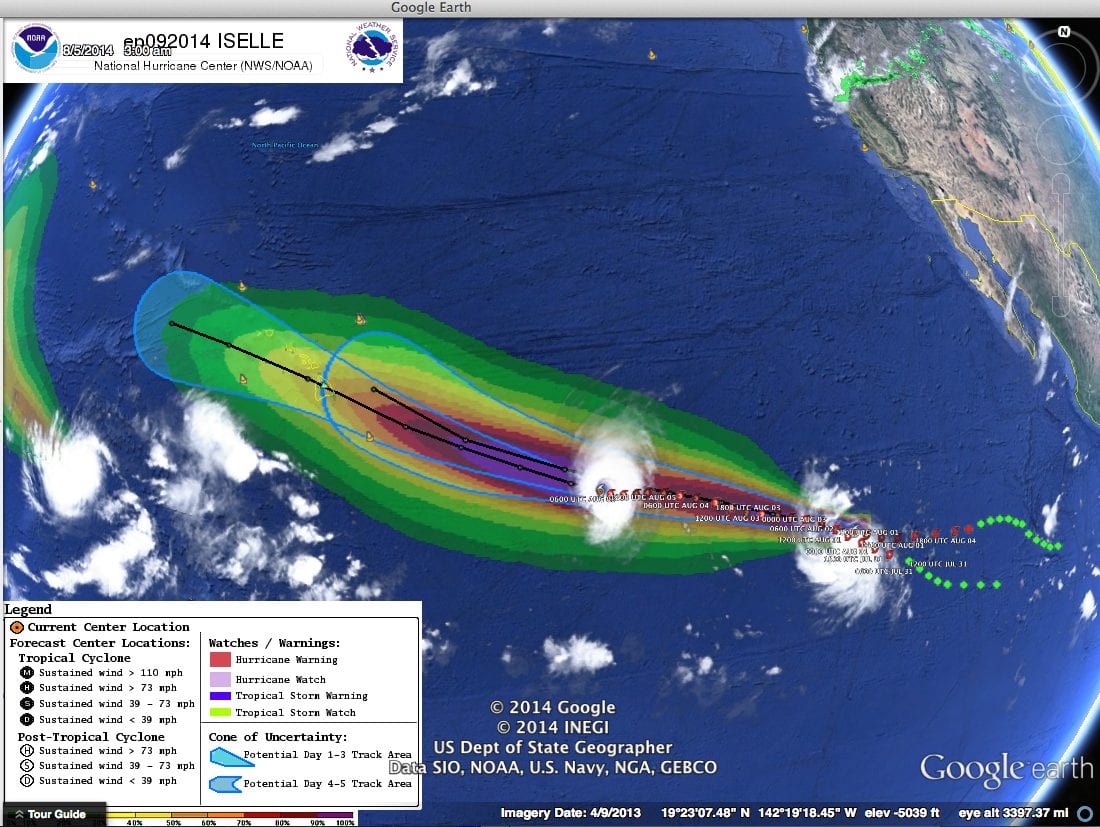
LOCATION…16.0N 139.5W
ABOUT 1055 MI…1700 KM ESE OF HILO HAWAII
MAXIMUM SUSTAINED WINDS…125 MPH…205 KM/H
PRESENT MOVEMENT…W OR 270 DEGREES AT 9 MPH…15 KM/H
MINIMUM CENTRAL PRESSURE…955 MB…28.20 INCHES
WATCHES AND WARNINGS
——————–
THERE ARE NO COASTAL WATCHES OR WARNINGS IN EFFECT.
INTERESTS IN THE HAWAIIAN ISLANDS SHOULD MONITOR THE PROGRESS OF
ISELLE. WATCHES MAY BE REQUIRED FOR PORTIONS OF THE ISLANDS BY
LATER TODAY OR EARLY WEDNESDAY.
DISCUSSION AND 48-HOUR OUTLOOK
——————————
AT 800 AM PDT…1500 UTC…THE CENTER OF HURRICANE ISELLE WAS
LOCATED NEAR LATITUDE 16.0 NORTH…LONGITUDE 139.5 WEST. ISELLE IS
MOVING TOWARD THE WEST NEAR 9 MPH…15 KM/H…AND THIS GENERAL
MOTION IS EXPECTED TO CONTINUE THIS MORNING. ISELLE SHOULD TURN
TOWARD THE WEST-NORTHWEST AT A FASTER FORWARD SPEED LATER TODAY AND
WEDNESDAY.
MAXIMUM SUSTAINED WINDS ARE NEAR 125 MPH…205 KM/H…WITH HIGHER
GUSTS. ISELLE IS A CATEGORY THREE HURRICANE ON THE SAFFIR-SIMPSON
HURRICANE WIND SCALE. WEAKENING IS FORECAST DURING THE NEXT 48
HOURS.
HURRICANE FORCE WINDS EXTEND OUTWARD UP TO 35 MILES…55 KM…FROM
THE CENTER…AND TROPICAL STORM FORCE WINDS EXTEND OUTWARD UP TO
115 MILES…185 KM.
THE ESTIMATED MINIMUM CENTRAL PRESSURE IS 955 MB…28.20 INCHES.
HAZARDS AFFECTING LAND
———————-
NONE.
NEXT ADVISORY
————-
THIS IS THE LAST PUBLIC ADVISORY ISSUED BY THE NATIONAL HURRICANE
CENTER ON ISELLE. FUTURE ADVISORIES WILL BE ISSUED BY THE CENTRAL
PACIFIC HURRICANE CENTER UNDER AWIPS HEADER HFOTCPCP3 AND WMO
HEADER WTPA33 PHFO…BEGINNING AT 1100 AM HST.
Home Public Adv Fcst Adv Discussion Wind Probs Graphics Archive
000
WTPZ24 KNHC 051450
TCMEP4
HURRICANE ISELLE FORECAST/ADVISORY NUMBER 21
NWS NATIONAL HURRICANE CENTER MIAMI FL EP092014
1500 UTC TUE AUG 05 2014
THERE ARE NO COASTAL WATCHES OR WARNINGS IN EFFECT.
INTERESTS IN THE HAWAIIAN ISLANDS SHOULD MONITOR THE PROGRESS OF
ISELLE. WATCHES MAY BE REQUIRED FOR PORTIONS OF THE ISLANDS BY
LATER TODAY OR EARLY WEDNESDAY.
HURRICANE CENTER LOCATED NEAR 16.0N 139.5W AT 05/1500Z
POSITION ACCURATE WITHIN 10 NM
PRESENT MOVEMENT TOWARD THE WEST OR 270 DEGREES AT 8 KT
ESTIMATED MINIMUM CENTRAL PRESSURE 955 MB
EYE DIAMETER 20 NM
MAX SUSTAINED WINDS 110 KT WITH GUSTS TO 135 KT.
64 KT……. 30NE 25SE 20SW 25NW.
50 KT……. 50NE 40SE 40SW 50NW.
34 KT…….100NE 90SE 60SW 80NW.
12 FT SEAS..210NE 150SE 150SW 210NW.
WINDS AND SEAS VARY GREATLY IN EACH QUADRANT. RADII IN NAUTICAL
MILES ARE THE LARGEST RADII EXPECTED ANYWHERE IN THAT QUADRANT.
REPEAT…CENTER LOCATED NEAR 16.0N 139.5W AT 05/1500Z
AT 05/1200Z CENTER WAS LOCATED NEAR 15.9N 139.0W
FORECAST VALID 08/1200Z 20.0N 156.5W…NEAR HAWAII
MAX WIND 55 KT…GUSTS 65 KT.
50 KT… 40NE 30SE 20SW 30NW.
34 KT…100NE 70SE 50SW 80NW.
EXTENDED OUTLOOK. NOTE…ERRORS FOR TRACK HAVE AVERAGED NEAR 125 NM
ON DAY 4 AND 175 NM ON DAY 5…AND FOR INTENSITY NEAR 15 KT EACH DAY
OUTLOOK VALID 09/1200Z 21.0N 162.0W
MAX WIND 45 KT…GUSTS 55 KT.
OUTLOOK VALID 10/1200Z 21.5N 166.5W
MAX WIND 35 KT…GUSTS 45 KT.
REQUEST FOR 3 HOURLY SHIP REPORTS WITHIN 300 MILES OF 16.0N 139.5W
THIS IS THE LAST FORECAST/ADVISORY ISSUED BY THE NATIONAL HURRICANE
CENTER ON ISELLE. FUTURE ADVISORIES WILL BE ISSUED BY THE CENTRAL
PACIFIC HURRICANE CENTER UNDER AWIPS HEADER HFOTCMCP3 AND WMO HEADER
WTPA23 PHFO…BEGINNING AT 05/2100Z.
Home Public Adv Fcst Adv Discussion Wind Probs Graphics Archive
000
WTPZ44 KNHC 051453
TCDEP4
HURRICANE ISELLE DISCUSSION NUMBER 21
NWS NATIONAL HURRICANE CENTER MIAMI FL EP092014
800 AM PDT TUE AUG 05 2014
Iselle has changed little in organization during the past six
hours. The eye remains well defined, with cloud tops to -70C
occurring in the eyewall. Analyses from the SHIPS model and from
CIMSS at the University of Wisconsin indicate 15-20 kt of
southwesterly vertical wind shear over the system. However, this
has not yet disrupted the inner core. The initial intensity remains
110 kt based on a combination of subjective and objective satellite
intensity estimates. An Air Force Reserve Hurricane Hunter aircraft
is scheduled to investigate Iselle near 06/0600Z, which will provide
ground truth for the intensity.
The initial motion estimate is 270/8 kt. The subtropical ridge to
the north of Iselle should strengthen during the next several days,
which should steer the cyclone generally west-northwestward with an
increase in forward speed. The track model guidance remains
tightly clustered and forecasts Iselle to pass near or over the
Hawaiian Islands in 72-84 hours. Based on this, the new forecast
track is again just an update of the previous track, and it lies in
the center of the track guidance envelope.
The analyzed and 24-hour forecast shear have both increased since
the previous advisory, and it is likely that Iselle will lose its
annular structure later today or tonight. This should result in
weakening along the lines of the previous forecast since a
significant part of the circulation is over sea surface temperatures
of less than 26C. The intensity forecast becomes more uncertain
after 36 hours. The cyclone will be moving over increasing sea
surface temperatures west of 152W. The dynamical models are in poor
agreement on how much shear the Iselle will experience, with the
UKMET forecasting strong shear while the GFS/ECMWF forecast less
shear. One last factor is that the cyclone is likely to encounter a
very dry air mass as it approaches Hawaii. The intensity guidance
responds to these factors by diverging. The SHIPS and Florida State
Superensemble forecast an intensity near 40 kt when Iselle gets near
Hawaii, while the GFDL and HWRF forecast it to be a hurricane. The
intensity forecast from 48-120 hours has been nudged upward in
agreement with the LGEM model and the intensity consensus, and it
calls for Iselle to be just below hurricane strength near Hawaii.
Interests in the Hawaiian Islands should closely monitor the
progress of Iselle. However, it is important not to focus too
closely on the exact track and intensity forecasts because the
average track error 72 hours out is about 100 miles, the average
intensity error is about 15 kt. In addition, the hazards of a
tropical cyclone can extend over a broad area well away from the
center.
This is the last advisory issued by the National Hurricane Center on
Iselle. Future Public Advisories will be issued by the Central
Pacific Hurricane Center under AWIPS header HFOTCPCP3 and WMO header
WTPA33 PHFO, while Forecast/Advisories will be issued under
AWIPS header HFOTCMCP3 and WMO header WTPA23 PHFO.


Leave a Reply