Tracking Hurricane Iselle
Issued: Aug 04, 2014 8:00 am HST
TROPICAL WEATHER OUTLOOK
NWS CENTRAL PACIFIC HURRICANE CENTER HONOLULU HI
800 AM HST MON AUG 4 2014
For the central north Pacific, between 140°W and 180.
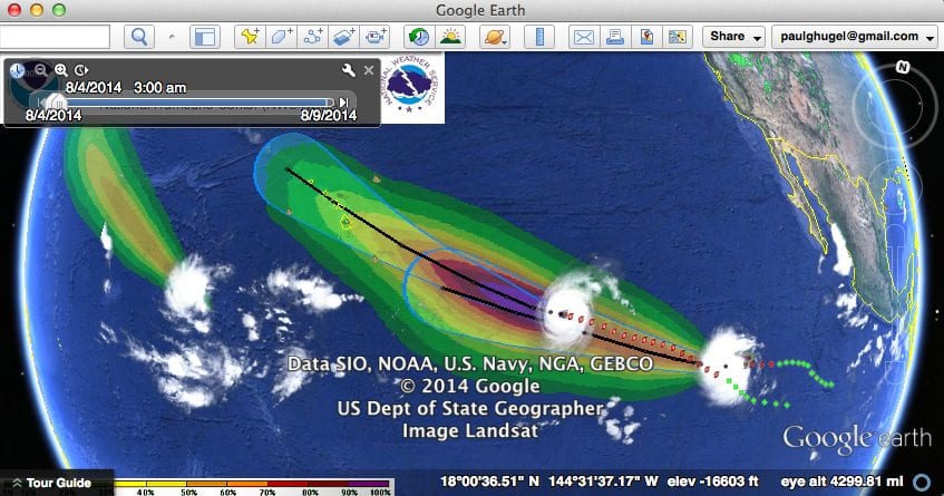
1. The National Hurricane Center in Miami Florida is issuing advisories on hurricane Iselle, located about 1200 miles east-southeast of Hilo Hawaii. Iselle is expected to cross 140°W into the Central Pacific Hurricane Center area of responsibility Tuesday morning.
2. The Central Pacific Hurricane Center in Honolulu Hawaii is issuing advisories on tropical depression Genevieve, located about 800 miles southwest of South Point Hawaii.
3. Disorganized showers and thunderstorms are associated with an area of low pressure about 450 miles south of Hilo Hawaii. Large scale conditions are not favorable for development of this system as it moves westward at 10 to 15 mph.* Formation chance through 48 hours, low, near 0 percent.
Elsewhere, no tropical cyclones are expected through Wednesday morning.
000
WTPZ44 KNHC 041436
TCDEP4
HURRICANE ISELLE DISCUSSION NUMBER 17
NWS NATIONAL HURRICANE CENTER MIAMI FL EP092014
800 AM PDT MON AUG 04 2014
Iselle continues to intensify and has reached category 4 strength.
Convective cloud tops as cold as -75C surround the eye, which has
grown to a diameter of 25-30 n mi. Dvorak estimates were a
consensus T6.0/115 kt from TAFB and SAB at 1200 UTC, and the
objective UW-CIMSS ADT has crept up to T6.3/122 kt since that time.
Based on these estimates, the initial intensity is raised to 120
kt. Vertical shear is expected to remain light for the next 24 hours
or so while Iselle moves over gradually cooler SSTs. Since Iselle
has some characteristics of an annular hurricane, it is likely to
change little in intensity during the next day or so, and even when
it begins to weaken, the trend should be gradual. On day 3, Iselle
will be moving over the coldest water (between 25 and 26C) along
its forecast track, and vertical shear is expected to increase to
about 15-20 kt. Both factors should induce quicker weakening at
that time. The NHC intensity forecast remains above all of the
typically used intensity models during the first 24 hours, is very
close to the consensus on days 2-3, and then more closely follows
the decay shown by the LGEM model toward the latter part of the
forecast period.
Iselle’s initial motion is 275/9 kt. A mid- to upper-level
shortwave trough is swinging by to the north of the hurricane and
eroding the subtropical ridge, which should cause Iselle to slow
down a bit during the next 24 hours. After that time, a mid-level
high is forecast to develop and strengthen between Hawaii and
California, forcing Iselle to turn west-northwestward and accelerate
as it approaches and moves near the Hawaiian Islands. The track
guidance has been stable and tightly clustered for a few cycles now,
and no significant changes were required to the NHC track forecast.
FORECAST POSITIONS AND MAX WINDS
INIT 04/1500Z 16.2N 136.5W 120 KT 140 MPH
12H 05/0000Z 16.2N 137.7W 115 KT 135 MPH
24H 05/1200Z 16.3N 139.2W 110 KT 125 MPH
36H 06/0000Z 16.8N 141.4W 95 KT 110 MPH
48H 06/1200Z 17.4N 144.2W 80 KT 90 MPH
72H 07/1200Z 19.0N 150.5W 60 KT 70 MPH…EAST OF HAWAII
96H 08/1200Z 21.0N 157.0W 50 KT 60 MPH…NEAR HAWAII
120H 09/1200Z 22.5N 162.0W 45 KT 50 MPH…WEST OF HAWAII
$$
Forecaster Berg


Leave a Reply