525
WTPA32 PHFO 220239
TCPCP2
BULLETIN
Hurricane Lane Advisory Number 29
NWS Central Pacific Hurricane Center Honolulu HI EP142018
500 PM HST Tue Aug 21 2018
…POWERFUL HURRICANE LANE CONTINUES MOVING CLOSER TO THE HAWAIIAN
ISLANDS…
…HURRICANE WARNING ISSUED FOR HAWAII COUNTY…
SUMMARY OF 500 PM HST…0300 UTC…INFORMATION
———————————————-
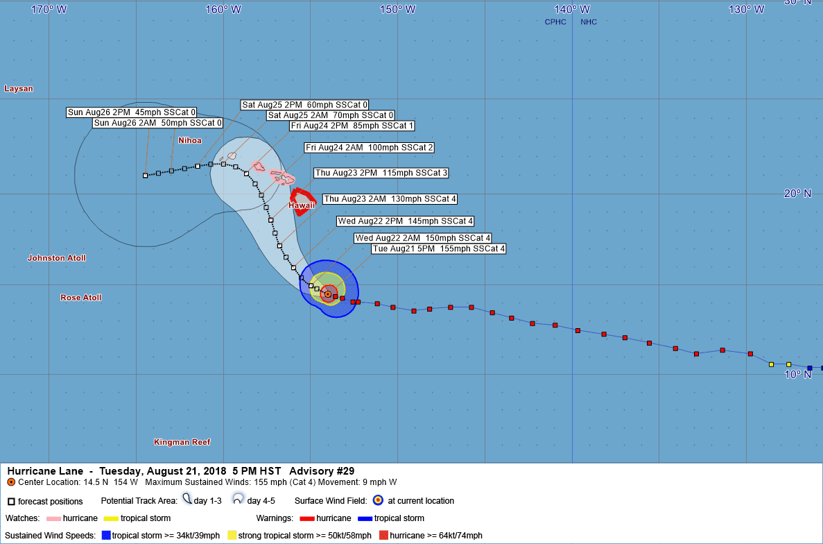
LOCATION…14.5N 154.0W
ABOUT 375 MI…605 KM SSE OF KAILUA-KONA HAWAII
ABOUT 535 MI…860 KM SSE OF HONOLULU HAWAII
MAXIMUM SUSTAINED WINDS…155 MPH…250 KM/H
PRESENT MOVEMENT…WNW OR 285 DEGREES AT 9 MPH…15 KM/H
MINIMUM CENTRAL PRESSURE…929 MB…27.44 INCHES
WATCHES AND WARNINGS
——————–
CHANGES WITH THIS ADVISORY:
A Hurricane Warning has been issued for Hawaii County.
A Hurricane Watch has been issued for Oahu.
SUMMARY OF WATCHES AND WARNINGS IN EFFECT:
A Hurricane Warning is in effect for…
* Hawaii County
A Hurricane Watch is in effect for…
* Maui County…including the islands of Maui, Lanai, Molokai and
Kahoolawe
* Oahu
A Hurricane Warning means that hurricane conditions are expected
somewhere within the warning area. A warning is typically issued
36 hours before the anticipated first occurrence of tropical-storm-
force winds, conditions that make outside preparations difficult
or dangerous. Preparations to protect life and property should be
rushed to completion.
A Hurricane Watch means that hurricane conditions are possible
within the watch area. A watch is typically issued 48 hours before
the anticipated first occurrence of tropical-storm-force winds,
conditions that make outside preparations difficult or dangerous.
Interests elsewhere in the main Hawaiian Islands, and across the
Northwestern Hawaiian Islands, should continue to closely monitor
the progress of Hurricane Lane. Additional Tropical Storm or
Hurricane Watches or Warnings may be issued tonight or Wednesday.
For storm information specific to your area, please monitor
products issued by the National Weather Service office in
Honolulu Hawaii.
DISCUSSION AND OUTLOOK
———————-
At 500 PM HST (0300 UTC), the center of Hurricane Lane was located
near latitude 14.5 North, longitude 154.0 West. Lane is moving
toward the west-northwest near 9 mph (15 km/h) and this motion is
expected to continue tonight. A turn toward the northwest is
expected on Wednesday, followed by a turn to the north-northwest on
Thursday. On the forecast track, the center of Lane will move very
close to or over the main Hawaiian Islands from Thursday through
Saturday.
Maximum sustained winds are near 155 mph (250 km/h) with higher
gusts. Lane is a category 4 hurricane on the Saffir-Simpson
Hurricane Wind Scale. Slow weakening is forecast during the
next 48 hours, but Lane is forecast to remain a dangerous
hurricane as it draws closer to the Hawaiian Islands.
Hurricane-force winds extend outward up to 40 miles (65 km) from the
center and tropical-storm-force winds extend outward up to 140 miles
(220 km).
The estimated minimum central pressure is 929 mb (27.44 inches).
HAZARDS AFFECTING LAND
———————-
WIND: Tropical storm conditions are expected within the
Hurricane Warning area beginning late Wednesday night into
early Thursday morning, with hurricane conditions expected
somewhere within the warning area on Thursday. Tropical storm
conditions are possible within the Hurricane Watch area beginning
Thursday into Thursday night, with hurricane conditions possible
late Thursday night into Friday.
RAINFALL: Excessive rainfall associated with Lane is expected
to affect portions of the Hawaiian Islands from late Wednesday into
the weekend, leading to flash flooding and landslides. Lane is
expected to produce total rain accumulations of 10 to 15 inches with
isolated amounts greater than 20 inches over the Hawaiian Islands.
SURF: Large swells generated by Lane will impact the Hawaiian
Islands, beginning tonight on the Big Island, spreading
across the remainder of the island chain on Wednesday. These
swells will produce large and potentially damaging surf along
exposed west, south and east facing shorelines.
NEXT ADVISORY
————-
Next intermediate advisory at 800 PM HST.
Next complete advisory at 1100 PM HST.
$$
Forecaster Jacobson
708
WTPA42 PHFO 220304
TCDCP2
Hurricane Lane Discussion Number 29
NWS Central Pacific Hurricane Center Honolulu HI EP142018
500 PM HST Tue Aug 21 2018
Lane remains a powerful hurricane this afternoon, with a well-
developed warm eye completely surrounded by persistent cold cloud
tops. The Hurricane Hunter aircraft from the 53rd Weather
Reconnaissance Squadron has been flying through Lane during the day,
and has provided invaluable data. The central pressure dropped
around 10 mb between the 18Z and 00Z fixes, with the last eye
dropsonde measuring 930 mb with 16 kt splash wind, yielding a
minimum pressure estimate of 929 mb. Peak SFMR winds during this
mission were 140 kt, and max flight level winds were 146 kt.
Subjective Dvorak current intensity estimates range from 6.5/127 kt
to 7.0/140 kt, with the latest ADT current intensity holding steady
at 6.5/127 kt. Although the central pressure has dropped sharply
during the last 18 hours, it is now about what one would expect for
a hurricane of strong Category 4 intensity in the Central Pacific
basin, and based primarily on the aircraft data the intial intensity
is held at 135 kt for this advisory.
Lane has turned slightly to the WNW today, and the initial motion
for this advisory is 285/8 kt. Lane has been moving generally
westward to the south of a mid-level ridge during the past several
days. However, this will be changing soon, as Lane begins to round
the western periphery of this ridge and moves into an area of
relatively light steering flow. This is expected to allow the
cyclone to gain latitude as its forward speed diminishes. The
hurricane is forecast to continue moving west-northwest tonight,
then turn to the northwest on Wednesday, and to the north-northwest
on Thursday, as it moves between the mid-level ridge to the east and
a developing upper-level trough to the northwest of Hawaii. After
this point, the track and intensity forecast become increasingly
uncertain, as the majority of the reliable model guidance
brings Lane very close to the islands with potential interaction
between Lane and the mountainous terrain of the islands. This
interaction combined with increasing vertical wind shear leads to a
weakened Lane being steered to the west by the low-level trade wind
flow during the later forecast periods. The new track forecast has
been nudged slightly to left through 36 hours, then slightly to the
right or closer to the islands at 72 hours, in very good agreement
with the multi-model consensus HCCA.
Water temperatures along the forecast track will be sufficiently
warm to support a major hurricane, and thus any significant
weakening before Lane draws closer to the Hawaiian Islands will
likely be due to increasing wind shear. Through the next 36 to 48
hours, shear is expected to remain light, and we expect only slow
weakening as the cyclone moves over slightly cooler SSTs and may be
impacted by eyewall replacement cycles. At 72 hours and beyond, the
forecast anticipates a sharp increase in shear as Lane moves closer
to the large upper trough to the northwest of the main Hawaiian
Islands. The new intensity forecast is very similar to the previous
forecast, and continues to follow the trend of the multi-model
consensus IVCN.
In addition to continued storm penetrations by the Hurricane Hunters
of the 53rd Weather Reconnaissance Squadron, the NOAA P-3 aircraft
will also be flying into Lane again this evening. The NOAA G-IV
aircraft once again sampled the larger scale environment during the
day to help with initialization of the forecast models.
KEY MESSAGES:
1. Lane is forecast to move dangerously close to the main Hawaiian
Islands as a hurricane later this week, potentially bringing
damaging winds and life-threatening flash flooding from heavy
rainfall anywhere in the state. As Lane is expected to be
slow-moving as it nears the islands, it will produce large and
damaging surf.
2. As Lane moves up from the southeast, the earliest potential
threat to land will be for the Big Island, where a Hurricane Warning
is now in effect. Preparations there should be rushed to completion
as tropical-storm force winds are forecast to arrive in the warning
area by late Wednesday or early Thursday. A Hurricane Watch remains
in effect for Maui County, and is now posted for Oahu, with
tropical-storm force winds possibly beginning Thursday or Thursday
night.
3. Due to a continued high degree of uncertainty on the forecast
track and intensity of Lane, hurricane impacts could be felt across
any of the Hawaiian Islands. It is too early to predict which, if
any, of the islands are directly impacted. Remember that life
threatening weather conditions can extend well away from the center
of the hurricane. Interests throughout Hawaii are urged to closely
monitor the progress of Lane during the next few days.
FORECAST POSITIONS AND MAX WINDS
INIT 22/0300Z 14.5N 154.0W 135 KT 155 MPH
12H 22/1200Z 15.0N 155.0W 130 KT 150 MPH
24H 23/0000Z 16.0N 156.0W 125 KT 145 MPH
36H 23/1200Z 17.2N 156.8W 115 KT 130 MPH
48H 24/0000Z 18.6N 157.3W 100 KT 115 MPH
72H 25/0000Z 21.1N 158.7W 75 KT 85 MPH
96H 26/0000Z 21.5N 161.5W 50 KT 60 MPH
120H 27/0000Z 21.0N 164.5W 40 KT 45 MPH
$$
Forecaster Jacobson


Leave a Reply