379
WTPA32 PHFO 221447
TCPCP2
BULLETIN
Hurricane Lane Advisory Number 32
NWS Central Pacific Hurricane Center Honolulu HI EP142018
500 AM HST Wed Aug 22 2018
…POWERFUL HURRICANE LANE CONTINUES MOVING WEST NORTHWESTWARD
TOWARD THE MAIN HAWAIIAN ISLANDS…
SUMMARY OF 500 AM HST…1500 UTC…INFORMATION
———————————————-
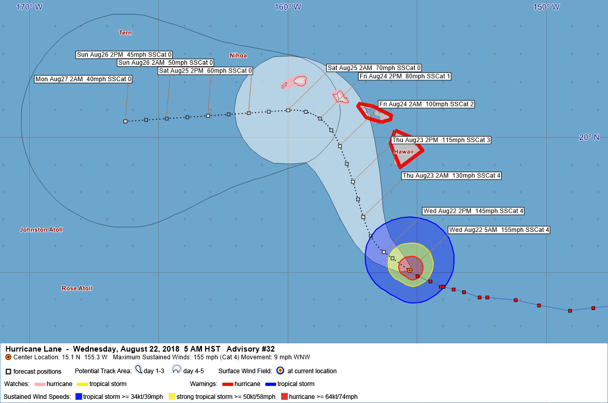
LOCATION…15.1N 155.3W
ABOUT 315 MI…505 KM S OF KAILUA-KONA HAWAII
ABOUT 460 MI…740 KM SSE OF HONOLULU HAWAII
MAXIMUM SUSTAINED WINDS…155 MPH…250 KM/H
PRESENT MOVEMENT…WNW OR 290 DEGREES AT 9 MPH…15 KM/H
MINIMUM CENTRAL PRESSURE…935 MB…27.61 INCHES
WATCHES AND WARNINGS
——————–
CHANGES WITH THIS ADVISORY:
A Hurricane Warning has been issued for…
* Maui County…including the islands of Maui, Lanai, Molokai and
Kahoolawe
A Hurricane Watch has been issued for…
* Kauai
SUMMARY OF WATCHES AND WARNINGS IN EFFECT:
A Hurricane Warning is in effect for…
* Hawaii County
* Maui County…including the islands of Maui, Lanai, Molokai and
Kahoolawe
A Hurricane Watch is in effect for…
* Oahu
* Kauai
A Hurricane Warning means that hurricane conditions are expected
somewhere within the warning area. A warning is typically issued
36 hours before the anticipated first occurrence of tropical-storm-
force winds, conditions that make outside preparations difficult
or dangerous. Preparations to protect life and property should be
rushed to completion.
A Hurricane Watch means that hurricane conditions are possible
within the watch area. A watch is typically issued 48 hours before
the anticipated first occurrence of tropical-storm-force winds,
conditions that make outside preparations difficult or dangerous.
Interests elsewhere in the main Hawaiian Islands, and across the
Northwestern Hawaiian Islands, should continue to closely monitor
the progress of Hurricane Lane. Additional Tropical Storm or
Hurricane Watches or Warnings may be issued tonight or Wednesday.
For storm information specific to your area, please monitor
products issued by the National Weather Service office in
Honolulu Hawaii.
DISCUSSION AND OUTLOOK
———————-
At 500 AM HST (1500 UTC), the center of Hurricane Lane was located
near latitude 15.1 North, longitude 155.3 West. Lane is moving
toward the west-northwest near 9 mph (15 km/h) and this motion is
expected to become northwest later today, followed by a
turn to the north-northwest on Thursday. On the forecast track, the
center of Lane will move very close to or over the main Hawaiian
Islands from Thursday through Saturday.
Maximum sustained winds are near 155 mph (250 km/h) with higher
gusts. Lane is a category 4 hurricane on the Saffir-Simpson
Hurricane Wind Scale. Some weakening is forecast during the next 48
hours, but Lane is forecast to remain a dangerous hurricane as it
draws closer to the Hawaiian Islands.
Hurricane-force winds extend outward up to 40 miles (65 km) from the
center and tropical-storm-force winds extend outward up to 140 miles
(220 km).
The estimated minimum central pressure is 935 mb (27.61 inches).
HAZARDS AFFECTING LAND
———————-
WIND: Tropical storm conditions are expected within the
Hurricane Warning area beginning late tonight into
early Thursday morning, with hurricane conditions expected
somewhere within the warning area on Thursday. Tropical storm
conditions are possible within the Hurricane Watch area beginning
Thursday into Thursday night, with hurricane conditions possible
late Thursday night into Friday.
RAINFALL: Excessive rainfall associated with Lane is expected
to affect portions of the Hawaiian Islands from late today
into the weekend, leading to flash flooding and landslides. Lane is
expected to produce total rain accumulations of 10 to 15 inches with
isolated amounts greater than 20 inches over the Hawaiian Islands.
SURF: Large swells generated by Lane will impact the Hawaiian
Islands, beginning this morning on the Big Island, spreading
across the remainder of the island chain on today. These
swells will produce large and potentially damaging surf along
exposed west, south and east facing shorelines.
NEXT ADVISORY
————-
Next intermediate advisory at 800 AM HST.
Next complete advisory at 1100 AM HST.
$$
Forecaster Powell
424
WTPA42 PHFO 221513
TCDCP2
Hurricane Lane Discussion Number 32
NWS Central Pacific Hurricane Center Honolulu HI EP142018
500 AM HST Wed Aug 22 2018
A bit of asymmetry within the coldest cloud tops is now noticeable,
but Lane remains a well-organized hurricane this morning. Outflow
remains best to the north through east and is slightly restricted
elsewhere. Hurricane Hunter aircraft from the 53rd Weather
Reconnaissance Squadron flew through Lane once again overnight,
deriving 130 kt within the northeast eyewall (using a blend of
observations). Subjective Dvorak current intensity estimates were
6.5/127 kt from all three centers. ADT from UW-CIMSS was also
6.5/127 kt. Initial intensity is set at 135 kt for this advisory,
which is slightly lower than for the last advisory.
Initial motion for this advisory is 290/8 kt. Lane has likely
reached the western periphery of a mid-level ridge and has made its
anticipated turn toward the west northwest. Lane is forecast to
turn to the northwest later today, and to the north-northwest on
Thursday, as it moves between the mid-level ridge to the east and a
developing upper-level trough to the northwest of Hawaii. The track
and intensity forecasts become increasingly uncertain after this
point as most track guidance brings Lane very close to the islands,
with potential interaction between Lane and the mountainous terrain
of the islands. UW-CIMMS derives 15 kt of vertical shear now and
this is forecast to increase to 25 to 30 kt at 48 hours, according
to ECMWF SHIPS. The combination of land interaction and increasing
vertical shear leads to a weakened Lane being steered to the west by
the low-level trade wind flow during the later forecast periods. The
new track forecast closely resembles the previous one and follows
HCCA and TVCE between GFS and ECMWF. A slight bump to the left was
made through 36 hours to account for initial motion, while a slight
bump to the right was made to keep the track within the guidance
envelop at 48 and 72 hours.
Water temperatures along the forecast track will be 27 to 28
degrees C, warm enough to support a major hurricane. Therefore, any
significant weakening as Lane draws closer to the Hawaiian Islands
will likely be due to increasing wind shear. Through the next 36
hours, shear is expected to remain in the 10 to 20 kt range, and we
expect only slow weakening initially. At 48 hours and beyond, the
forecast incorporates an expected sharp increase in shear as Lane
moves closer to the large upper trough to the northwest of the main
Hawaiian Islands. The new intensity forecast is very similar to the
previous forecast and lies near the top of the guidance envelope
but not too far from HMNI and IVCN.
KEY MESSAGES:
1. Lane is forecast to move dangerously close to the main Hawaiian
Islands as a hurricane tomorrow through Saturday, potentially
bringing damaging winds and life-threatening flash flooding from
heavy rainfall. As Lane will be slow-moving as it nears the
islands, large and damaging surf can be expected along exposed
shorelines, along with localized storm surge.
2. As Lane approaches the islands from the southeast, initial
impacts will be felt on the Big Island and Maui County, where a
Hurricane Warning is in effect. Impacts on Kauai County and Oahu
are also possible, and a Hurricane Watch is in effect there.
3. Do not focus on the exact forecast track for Lane, as life-
threatening weather conditions extend well away from the center of
the hurricane, and significant impacts could be felt on any of the
islands.
FORECAST POSITIONS AND MAX WINDS
INIT 22/1500Z 15.1N 155.3W 135 KT 155 MPH
12H 23/0000Z 15.8N 156.3W 125 KT 145 MPH
24H 23/1200Z 17.1N 157.1W 115 KT 130 MPH
36H 24/0000Z 18.4N 157.5W 100 KT 115 MPH
48H 24/1200Z 19.7N 158.0W 85 KT 100 MPH
72H 25/1200Z 21.0N 160.0W 60 KT 70 MPH
96H 26/1200Z 20.8N 163.1W 45 KT 50 MPH
120H 27/1200Z 20.6N 166.3W 35 KT 40 MPH
$$
Forecaster Powell


Leave a Reply