
894
WTPA32 PHFO 231758
TCPCP2
BULLETIN
Hurricane Lane Intermediate Advisory Number 36A
NWS Central Pacific Hurricane Center Honolulu HI EP142018
800 AM HST Thu Aug 23 2018
…LANE CONTINUES TO APPROACH THE MAIN HAWAIIAN ISLANDS WITH
TORRENTIAL RAINFALL ALREADY OCCURRING IN SOME AREAS…
SUMMARY OF 800 AM HST…1800 UTC…INFORMATION
———————————————-
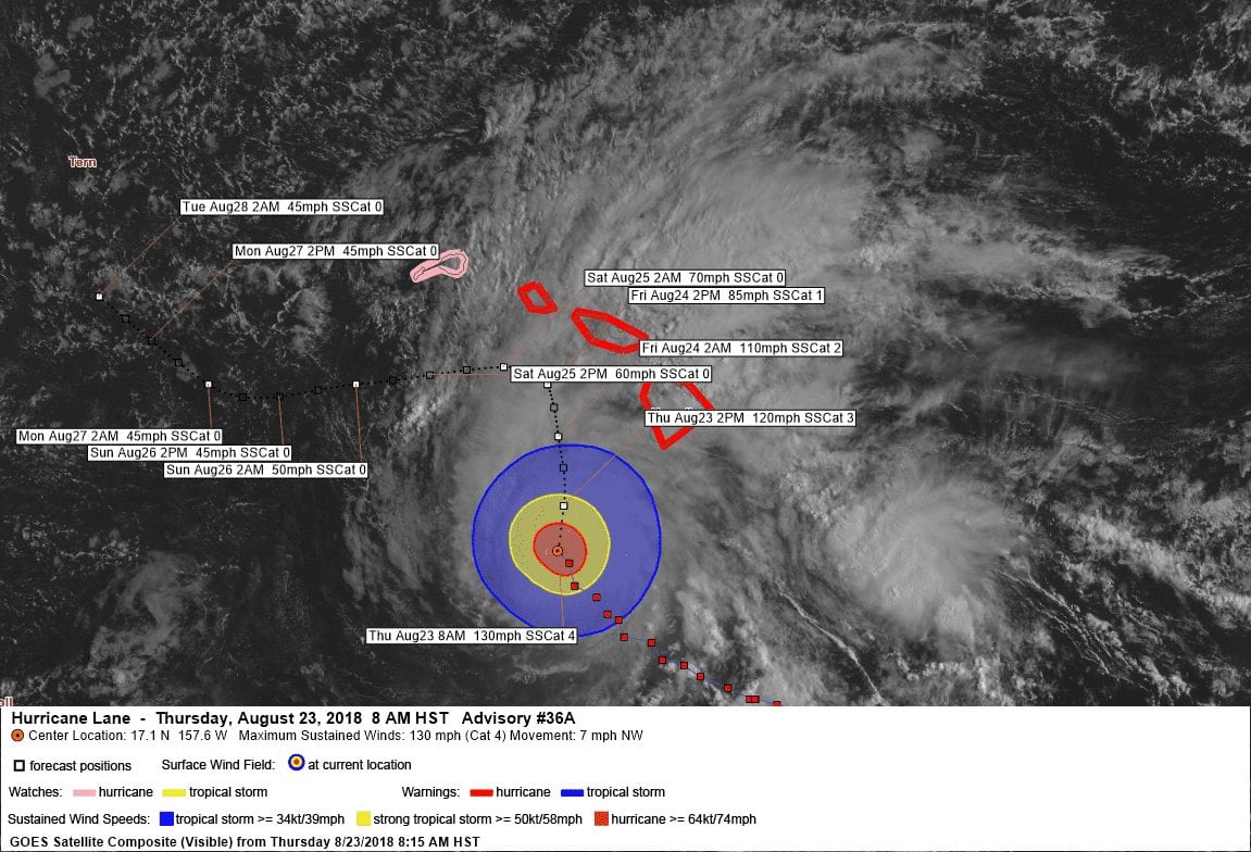
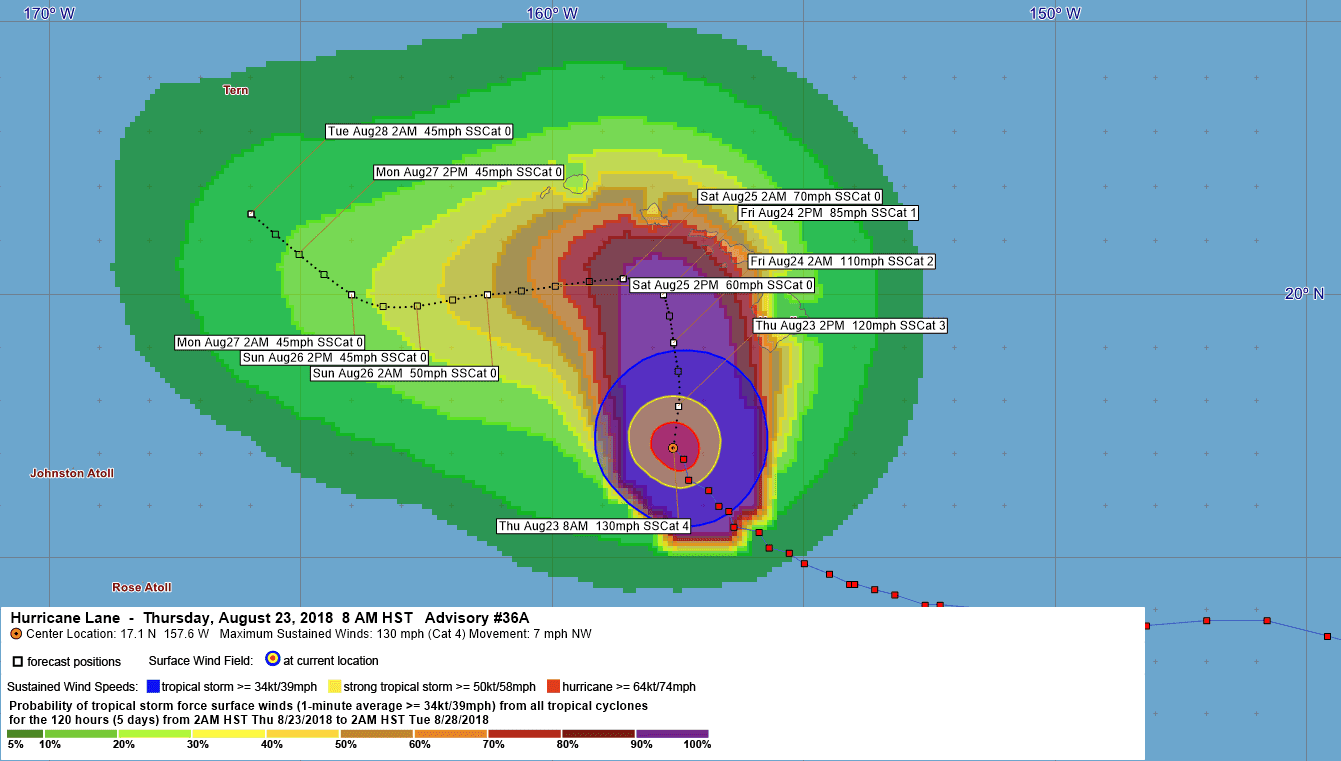
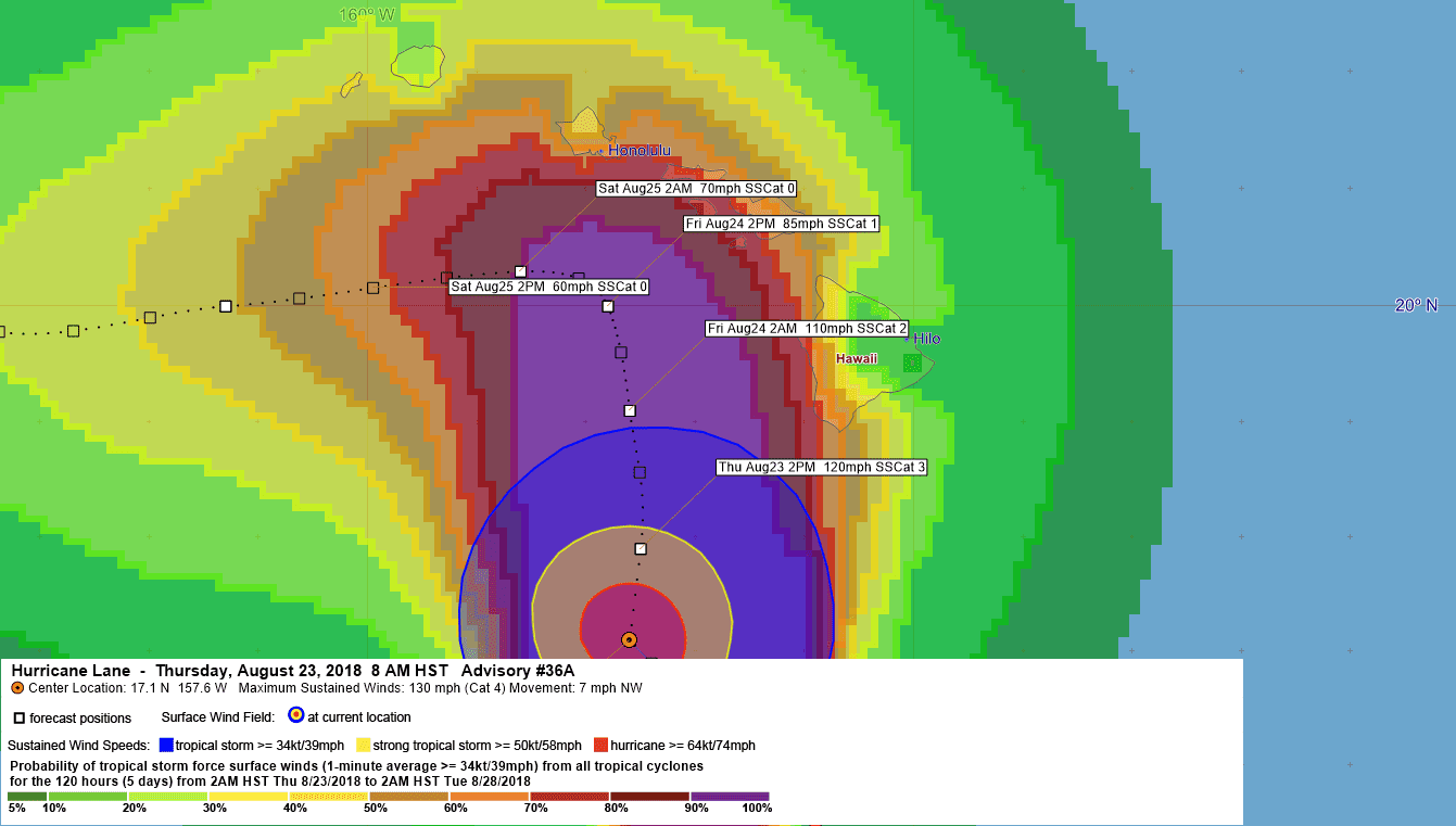
LOCATION…17.1N 157.6W
ABOUT 205 MI…330 KM SW OF KAILUA-KONA HAWAII
ABOUT 290 MI…465 KM S OF HONOLULU HAWAII
MAXIMUM SUSTAINED WINDS…130 MPH…215 KM/H
PRESENT MOVEMENT…NW OR 320 DEGREES AT 7 MPH…11 KM/H
MINIMUM CENTRAL PRESSURE…949 MB…28.03 INCHES
WATCHES AND WARNINGS
——————–
CHANGES WITH THIS ADVISORY:
None.
SUMMARY OF WATCHES AND WARNINGS IN EFFECT:
A Hurricane Warning is in effect for…
* Oahu
* Maui County…including the islands of Maui, Lanai, Molokai and
Kahoolawe
* Hawaii County
A Hurricane Watch is in effect for…
* Kauai County…including the islands of Kauai and Niihau
A Hurricane Warning means that hurricane conditions are expected
somewhere within the warning area. A warning is typically issued
36 hours before the anticipated first occurrence of tropical-storm-
force winds, conditions that make outside preparations difficult
or dangerous. Preparations to protect life and property should be
rushed to completion.
A Hurricane Watch means that hurricane conditions are possible
within the watch area. A watch is typically issued 48 hours before
the anticipated first occurrence of tropical-storm-force winds,
conditions that make outside preparations difficult or dangerous.
Interests in the the Northwestern Hawaiian Islands should monitor
the progress of Hurricane Lane.
For storm information specific to your area, please monitor
products issued by the National Weather Service office in
Honolulu Hawaii.
DISCUSSION AND OUTLOOK
———————-
At 800 AM HST (1800 UTC), the center of Hurricane Lane was located
by satellite and radar imagery near near latitude 17.1 North,
longitude 157.6 West. Lane is moving toward the northwest near 7 mph
(11 km/h). A turn toward the north-northwest and little change in
forward speed is expected today. A turn toward the north is
anticipated tonight and Friday, as Lane’s forward motion slows. A
turn toward the west is expected on Saturday and Sunday, with an
increase in forward speed. On the forecast track, the center of Lane
will move very close to or over the portions of the main Hawaiian
islands later today through Friday.
Maximum sustained winds are near 130 mph (215 km/h) with higher
gusts. Lane is a powerful category 4 hurricane on the Saffir-Simpson
Hurricane Wind Scale. Steady weakening is forecast during the next
couple of days. Lane is expected to remain a hurricane as it draws
closer to the islands.
Hurricane-force winds extend outward up to 35 miles (55 km) from
the center and tropical-storm-force winds extend outward up to 140
miles (220 km). NOAA buoy 51002 located about 250 miles southwest of
the Big Island recently reported sustained winds of 71 mph (114
km/h) and a gust of 94 mph (151 km/h).
The estimated minimum central pressure is 949 mb (28.03 inches).
HAZARDS AFFECTING LAND
———————-
WIND: Tropical storm conditions are expected on portions of the Big
Island beginning later this morning, with hurricane conditions
expected in some areas by tonight. Tropical storm conditions are
expected to begin over portions of Maui County later today,
with hurricane conditions expected in some areas by Friday.
Tropical storm conditions are expected to begin on Oahu late
tonight, with hurricane conditions expected Friday into Friday
night.
RAINFALL: Rain bands from Hurricane Lane will continue to overspread
the Hawaiian Islands. Excessive rainfall associated with Lane will
impact the Hawaiian Islands into the weekend, leading to significant
and life-threatening flash flooding and landslides. Lane is expected
to produce total rain accumulations of 10 to 20 inches, with
localized amounts in excess of 30 inches over the Hawaiian Islands.
Over 12 inches of rain has already fallen on portions of the Big
Island.
SURF: As Lane is slow-moving, large swells generated by the
hurricane will severely impact the Hawaiian Islands over the next
couple of days. These swells will produce very large and damaging
surf along exposed west and south facing shorelines. A prolonged
period of high surf will likely lead to significant coastal erosion.
STORM SURGE: The combination of a dangerous storm surge and large
breaking waves will raise water levels by as much as 2 to 4 feet
above normal tide levels along south and west facing shores near
the center of Lane. The surge will be accompanied by large and
destructive waves.
NEXT ADVISORY
————-
Next complete advisory at 1100 AM HST.
$$
Forecaster R Ballard
678
WTPA42 PHFO 231502
TCDCP2
Hurricane Lane Discussion Number 36
NWS Central Pacific Hurricane Center Honolulu HI EP142018
500 AM HST Thu Aug 23 2018
Lane’s satellite appearance has degraded somewhat since the previous
advisory as southwesterly shear impacts the vertical integrity of
the cyclone. However, the eye is still evident in traditional
infrared imagery and remains surrounded by a solid ring of cold
cloud tops. Water vapor imagery shows Lane’s circulation
becoming elongated, with outflow severely restricted in the
southwest semicircle. The subjective Dvorak current intensity
estimates from GTW/TAFB/HFO/SAB ranged from 6.0/115 kt to 6.5/127 kt
for this advisory, while data-T numbers were as low as 5.5/105 kt.
Using a blend, the initial intensity for this advisory is set at 115
kt.
Lane is currently moving toward the northwest into an increasingly
hostile environment between a deep-layer ridge to the east, and a
trough aloft to the northwest. The initial motion for this advisory
is 320/6 kt, with southwesterly shear estimated to be around
25 kt by UW-CIMSS.
The track and intensity forecast are extremely dependent on one
another in the current forecast scenario, with Lane expected to
move generally toward the north while it remains a hurricane, and
generally toward the west once it weakens. Confidence in the
forecast is reduced because it is uncertain how Lane’s core will be
impacted by its potential interaction with island terrain, and the
subsequent rate of weakening. Regardless of whether Lane’s center
moves over one of the Hawaiian Islands, an increasing amount of
southwesterly shear along the forecast track will lead to
significant weakening. If Lane’s core were to move over one of the
islands as has been consistently depicted by GFS/HWRF, then the
cyclone would weaken even more rapidly. EMX2 is on the left side of
the guidance and indicates less interaction with island terrain,
and therefore a slightly slower rate of weakening.
Based on a preponderance of evidence presented by the guidance, the
updated forecast indicates a faster rate of weakening than
indicated earlier, especially on days 2 and 3. The expectation is
that Lane will weaken due to the combined and cumulative effects of
debilitating shear and the interruption of the circulation due to
proximity to the high mountains of Maui and the Big Island. The
official intensity forecast now closely follows IVCN, SHIPS and the
ECMWF-based SHIPS. The track forecast anticipates this weakening,
with Lane turning sharply toward the west on day 3. Until then, the
forecast track is shifted slightly to the right of the previous
forecast through Friday, bringing Lane northward and very close to
the Big Island and Maui County. This is similar to the multi-model
consensus HCCA, which includes GFS and HWRF as weighted members. A
slow forward speed is expected as this occurs, with Lane then moving
more quickly toward west as it becomes shallow and carried by the
low-level trade wind flow.
NOAA Buoy 51002 to the southwest of the islands is in the path of
Lane, and recently reported a wind gust to 56 kt and significant
wave heights near 23 ft. Associated data were used to refine wind
and seas radii in the northwest quadrant.
KEY MESSAGES:
1. Lane will pass dangerously close to the main Hawaiian Islands as
a hurricane today and Friday, and is expected to bring damaging
winds. These winds can be accelerated over and downslope from
elevated terrain, and will be higher in high rise buildings.
2. The slow movement of Lane also greatly increases the threat for
prolonged heavy rainfall and extreme rainfall totals. This is
expected to lead to life-threatening flash flooding and landslides
over all Hawaiian Islands.
3. Large and damaging surf can be expected along exposed
shorelines, especially along south and west facing coasts, with
localized storm surge exacerbating the impacts of a prolonged period
of damaging surf.
4. Do not focus on the exact forecast track or intensity of Lane,
and be prepared for adjustments to the forecast. Although the
official forecast does not explicitly indicate Lane’s center making
landfall over any of the islands, this could still occur. Even if
the center of Lane remains offshore, severe impacts could still be
realized as they extend well away from the center.
FORECAST POSITIONS AND MAX WINDS
INIT 23/1500Z 16.9N 157.4W 115 KT 130 MPH
12H 24/0000Z 17.9N 157.5W 105 KT 120 MPH
24H 24/1200Z 19.1N 157.6W 95 KT 110 MPH
36H 25/0000Z 20.0N 157.8W 75 KT 85 MPH
48H 25/1200Z 20.3N 158.6W 60 KT 70 MPH
72H 26/1200Z 20.0N 161.3W 45 KT 50 MPH
96H 27/1200Z 20.0N 164.0W 40 KT 45 MPH
120H 28/1200Z 21.5N 166.0W 40 KT 45 MPH
$$
Forecaster Birchard


Leave a Reply