WTPA32 PHFO 230249
TCPCP2
BULLETIN
Hurricane Lane Advisory Number 34
NWS Central Pacific Hurricane Center Honolulu HI EP142018
500 PM HST Wed Aug 22 2018
…DANGEROUS HURRICANE LANE TRACKING NORTHWEST AND ON COURSE TO
PASS VERY CLOSE TO THE ISLANDS THURSDAY AND FRIDAY…
SUMMARY OF 500 PM HST…0300 UTC…INFORMATION
———————————————-
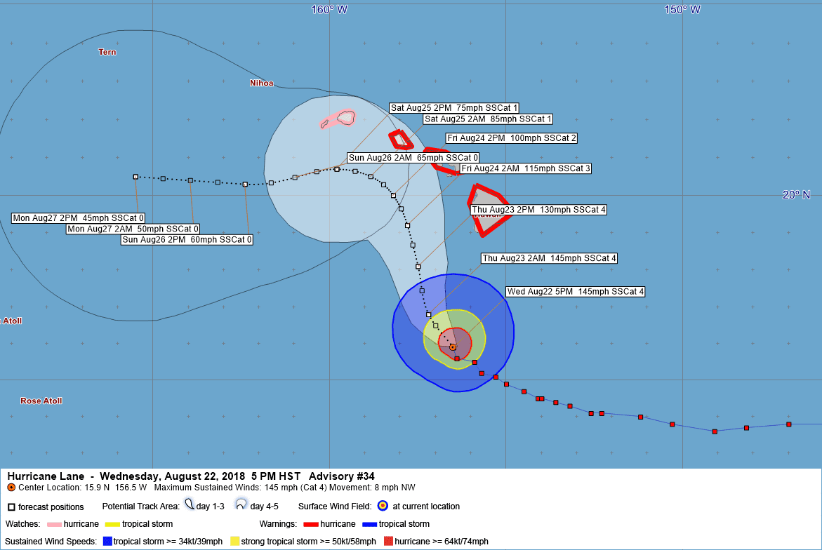
LOCATION…15.9N 156.5W
ABOUT 260 MI…415 KM S OF KAILUA-KONA HAWAII
ABOUT 385 MI…620 KM SSE OF HONOLULU HAWAII
MAXIMUM SUSTAINED WINDS…145 MPH…230 KM/H
PRESENT MOVEMENT…NW OR 310 DEGREES AT 8 MPH…13 KM/H
MINIMUM CENTRAL PRESSURE…939 MB…27.73 INCHES
WATCHES AND WARNINGS
——————–
CHANGES WITH THIS ADVISORY:
The Hurricane Watch has been changed to a Hurricane Warning for the
island of Oahu.
SUMMARY OF WATCHES AND WARNINGS IN EFFECT:
A Hurricane Warning is in effect for…
* Oahu
* Maui County…including the islands of Maui, Lanai, Molokai and
Kahoolawe
* Hawaii County
A Hurricane Watch is in effect for…
* Kauai County…including the islands of Kauai and Niihau
A Hurricane Warning means that hurricane conditions are expected
somewhere within the warning area. A warning is typically issued
36 hours before the anticipated first occurrence of tropical-storm-
force winds, conditions that make outside preparations difficult
or dangerous. Preparations to protect life and property should be
rushed to completion.
A Hurricane Watch means that hurricane conditions are possible
within the watch area. A watch is typically issued 48 hours before
the anticipated first occurrence of tropical-storm-force winds,
conditions that make outside preparations difficult or dangerous.
Interests in the the Northwestern Hawaiian Islands should monitor
the progress of Hurricane Lane.
For storm information specific to your area, please monitor
products issued by the National Weather Service office in
Honolulu Hawaii.
DISCUSSION AND OUTLOOK
———————-
At 500 PM HST (0300 UTC), the eye of Hurricane Lane was located
near latitude 15.9 North, longitude 156.5 West. Lane is moving
toward the northwest near 8 mph (13 km/h). This motion is
expected to continue tonight, with a turn toward the north and a
slower forward motion expected on Friday. A turn back toward the
west is expected on Saturday. On the forecast track, the center of
Lane will move very close to or over the main Hawaiian Islands
Thursday and Friday.
Maximum sustained winds are near 145 mph (230 km/h) with higher
gusts. Lane is a powerful category 4 hurricane on the Saffir-Simpson
Hurricane Wind Scale. Some weakening is forecast during the next
few days, but Lane is expected to remain a hurricane as it
approaches the islands.
Hurricane-force winds extend outward up to 40 miles (65 km) from the
center and tropical-storm-force winds extend outward up to 140 miles
(220 km).
The estimated minimum central pressure is 939 mb (27.73 inches).
HAZARDS AFFECTING LAND
———————-
WIND: Tropical storm conditions are expected on portions of the Big
Island beginning early Thursday morning, with hurricane conditions
expected in some areas Thursday afternoon or Thursday night.
Tropical storm conditions are expected to begin over portions of
Maui county on Thursday, with hurricane conditions expected in some
areas Thursday night into Friday. Tropical storm conditions are
expected to begin on Oahu late Thursday night, with hurricane
conditions expected Friday.
RAINFALL: Rainbands from Hurricane Lane will continue to gradually
overspread the state tonight and Thursday. Excessive rainfall
associated with Lane is expected to affect portions of the Hawaiian
Islands from late today into the weekend. This could lead to major
flash flooding and landslides. Lane is expected to produce total
rain accumulations of 10 to 15 inches with localized amounts in
excess of 20 inches over the Hawaiian Islands.
SURF: Large swells generated by Lane will impact the Hawaiian
Islands, spreading across the island chain tonight and Thursday.
These swells will produce very large and potentially damaging surf
along exposed west, south and east facing shorelines.
STORM SURGE: The combination of a dangerous storm surge and large
breaking waves will raise water levels by as much as 2 to 4 feet
above normal tide levels along south and west facing shores near
the center of Lane. The surge will be accompanied by large and
destructive waves.
NEXT ADVISORY
————-
Next intermediate advisory at 800 PM HST.
Next complete advisory at 1100 PM HST.
$$
Forecaster R Ballard
122
WTPA42 PHFO 230315
TCDCP2
Hurricane Lane Discussion Number 34
NWS Central Pacific Hurricane Center Honolulu HI EP142018
500 PM HST Wed Aug 22 2018
The eye of Lane has become a bit less distinct in visible and
infrared imagery over the past few hours, but the core structure
remains well organized. Satellite intensity estimates were 6.0 from
SAB and TAFB, and 6.5 from PHFO and JTWC. The CIMSS-ADT remained
steady at 6.3. The current intensity was set to 125 kt, based on
the consensus of the satellite estimates.
Unfortunately Lane appears to have started a more northwest motion,
310/7 over the past several hours. A deep layer ridge to the east
and southeast of Lane is expected to build south of the tropical
cyclone over the next 24 to 36 hours, which will impart a more
northward motion. By 48 to 72 hours, the track guidance begins to
show a sharp westward turn, as the low level circulation of Lane
decouples in the face of 35 to 40 kt of shear. Exactly when this
critical turn will happen is very difficult to forecast, so
confidence in this portion of the track is quite low and
necessitates expanding the Hurricane Warning to Oahu with this
forecast package. The track forecast is virtually unchanged from the
previous advisory in this time frame, and now closely follows the
HCCA and other consensus guidance, which shifted slightly to
the northeast around the time of closest approach to the islands.
Beyond 72 hours, the shallow circulation of Lane is expected to be
carried westward in the trades.
Lane is beginning to move underneath increasing shear as shown in
an animation of UW-CIMSS shear analyses. The shear is expected to
remain moderate for the first 24 to 36 hours, then become quite
strong beyond 48 hours. A gradual weakening trend is shown through
48 hours, with more rapid weakening beyond that time frame. The
intensity forecast remains on the high end of the guidance, in best
agreement with the ECMWF which maintains the deeper circulation
of Lane the longest.
KEY MESSAGES:
1. Lane will pass dangerously close to the main Hawaiian
Islands as a hurricane Thursday and Friday, and is expected to bring
damaging winds. These winds can be accelerated over and downslope
from higher terrain, and higher in high rise buildings.
2. The slow movement of Lane also greatly increases the threat for
prolonged heavy rainfall, life-threatening flash flooding, and
landslides. The flood threat in particular will extend far to the
east and northeast of the center of Lane.
3. Large and damaging surf can be expected along exposed shorelines,
along with localized storm surge.
4. Do not focus on the exact forecast track or intensity of Lane,
and be prepared for adjustments to the forecast. Life threatening
impacts can extend well away from the center of a hurricane.
FORECAST POSITIONS AND MAX WINDS
INIT 23/0300Z 15.9N 156.5W 125 KT 145 MPH
12H 23/1200Z 16.8N 157.2W 125 KT 145 MPH
24H 24/0000Z 18.1N 157.5W 115 KT 130 MPH
36H 24/1200Z 19.2N 157.8W 100 KT 115 MPH
48H 25/0000Z 20.0N 158.2W 85 KT 100 MPH
72H 26/0000Z 20.7N 159.8W 65 KT 75 MPH
96H 27/0000Z 20.3N 162.4W 50 KT 60 MPH
120H 28/0000Z 20.5N 165.5W 40 KT 45 MPH
$$
Forecaster R Ballard


Leave a Reply