
119
WTPA32 PHFO 241807
TCPCP2
BULLETIN
Hurricane Lane Intermediate Advisory Number 40A
NWS Central Pacific Hurricane Center Honolulu HI EP142018
800 AM HST Fri Aug 24 2018
…HURRICANE LANE LURKING JUST SOUTH OF THE ISLANDS BRINGING
STRONG WINDS AND SIGNIFICANT FLOODING TO SOME AREAS…
SUMMARY OF 800 AM HST…1800 UTC…INFORMATION
———————————————-
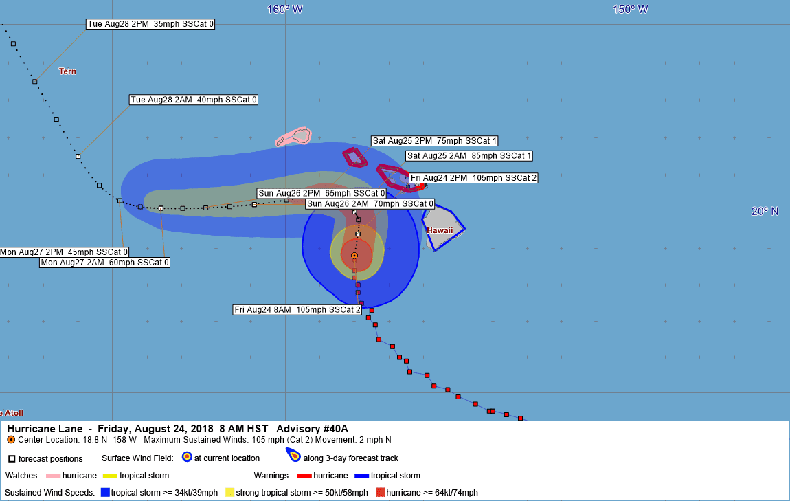
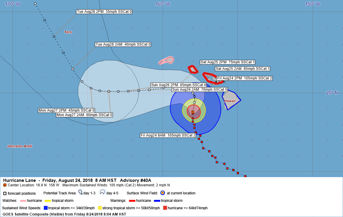
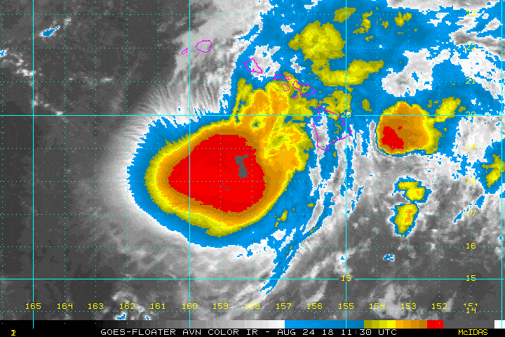
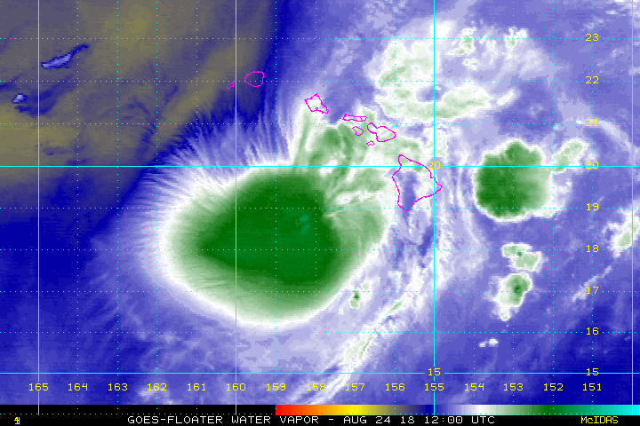
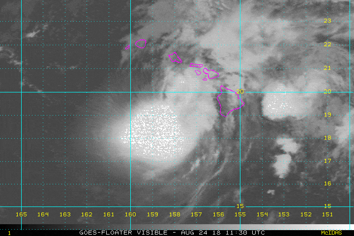
LOCATION…18.8N 158.0W
ABOUT 170 MI…274 KM S OF HONOLULU HAWAII
ABOUT 140 MI…225 KM WSW OF KAILUA-KONA HAWAII
MAXIMUM SUSTAINED WINDS…105 MPH…170 KM/H
PRESENT MOVEMENT…N OR 360 DEGREES AT 2 MPH…3 KM/H
MINIMUM CENTRAL PRESSURE…964 MB…28.47 INCHES
WATCHES AND WARNINGS
——————–
CHANGES WITH THIS ADVISORY:
None.
SUMMARY OF WATCHES AND WARNINGS IN EFFECT:
A Hurricane Warning is in effect for…
* Oahu
* Maui County…including the islands of Maui, Lanai, Molokai and
Kahoolawe
A Tropical Storm Warning is in effect for…
* Hawaii County
A Hurricane Watch is in effect for…
* Kauai County…including the islands of Kauai and Niihau
A Hurricane Warning means that hurricane conditions are expected
somewhere within the warning area. Preparations to protect life and
property should already be complete.
A Tropical Storm Warning means that tropical storm conditions are
expected somewhere within the warning area.
A Hurricane Watch means that hurricane conditions are possible
within the watch area.
Interests in the Northwestern Hawaiian Islands should monitor
the progress of Hurricane Lane.
For storm information specific to your area, please monitor
products issued by the National Weather Service office in
Honolulu Hawaii.
DISCUSSION AND OUTLOOK
———————-
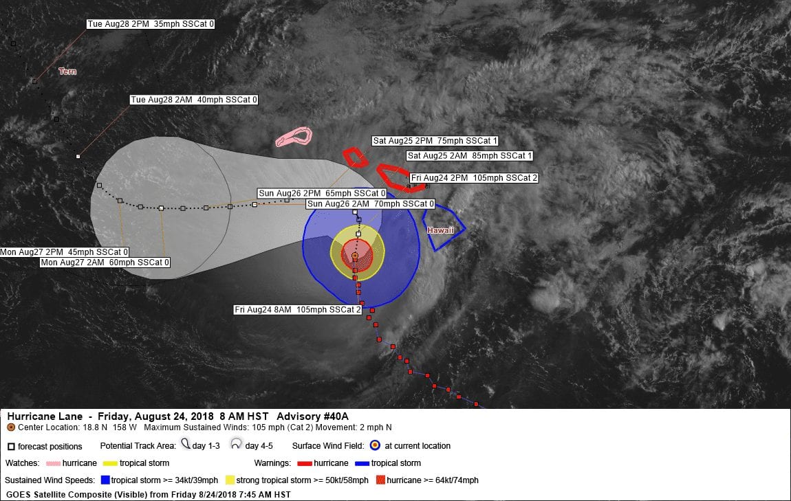
At 800 AM HST (1800 UTC), the center of Hurricane Lane was
estimated by radar and satellite to be near latitude 18.8 North,
longitude 158.0 West. Lane is moving toward the north near 2 mph (3
km/h), and this general motion is expected to continue through
tonight. A turn toward the west is anticipated on Saturday, with an
increase in forward speed. On the latest forecast track, the center
of Lane will move dangerously close to portions of the central
Hawaiian islands later today and tonight.
Maximum sustained winds are near 105 mph (170 km/h) with higher
gusts. Some additional weakening is forecast later today and
tonight, but Lane is expected to remain a dangerous hurricane as it
approaches the islands. Further weakening is expected on Saturday.
Hurricane-force winds extend outward up to 35 miles (55 km) from
the center and tropical-storm-force winds extend outward up to 140
miles (220 km).
A weather station near Waimea on the Big Island recently reported
sustained winds of 45 mph (72 km/h) with gusts to 51 mph (82 km/h).
The estimated minimum central pressure is 962 mb (28.47 inches).
HAZARDS AFFECTING LAND
———————-
WIND: Tropical storm conditions are already occurring on the Big
Island, Maui County and Oahu. These conditions will likely persist
today. Hurricane conditions are expected over some areas of Maui
County and Oahu starting tonight. Tropical storm or hurricane
conditions are possible on Kauai starting tonight or Saturday.
RAINFALL: Rain bands will continue to overspread the Hawaiian
Islands well ahead of Lane. Excessive rainfall associated with this
slow moving hurricane will continue to impact the Hawaiian Islands
into the weekend, leading to catastrophic and life-threatening flash
flooding and landslides. Lane is expected to produce total rain
accumulations of 10 to 20 inches, with localized amounts up to 40
inches possible over portions of the Hawaiian Islands. Over 30
inches of rain has already fallen at a couple locations on the
windward side of the Big Island.
SURF: Very large swells generated by the slow moving hurricane will
severely impact the Hawaiian Islands into this weekend. These swells
will produce life-threatening and damaging surf along exposed
shorelines, particularly today through Saturday. In addition, a
prolonged period of extreme surf will also likely lead to
significant coastal erosion.
STORM SURGE: The combination of a dangerous storm surge and large
breaking waves will raise water levels by as much as 2 to 4 feet
above normal tide levels along south and west facing shores near
the center of Lane. The surge will be accompanied by large and
destructive waves.
NEXT ADVISORY
————-
Next complete advisory at 1100 AM HST.
$$
Forecaster R Ballard
737
WTPA42 PHFO 241518
TCDCP2
Hurricane Lane Discussion Number 40…Corrected
NWS Central Pacific Hurricane Center Honolulu HI EP142018
500 AM HST Fri Aug 24 2018
Hurricane Lane continues to signs of slow weakening due to wind
shear of 20 to 30 knots from the southwest according to the latest
SHIPS and UW-CIMSS analyses. There is no eye evident in satellite
imagery, which is likely a result of these hostile conditions. Radar
reflectivity data from the WSR-88D radars at Molokai and Kohala show
the center is becoming disrupted. The latest satellite intensity
estimates from HFO, JTWC, TAFB and SAB were a unanimous T5.0/90
knots, while the UW-CIMSS ADT was T5.4/100 knots. Based on a blend
of these estimates, the current intensity has been lowered to 95
knots.
Lane began to turn northward Thursday evening, and the current
motion is 360/4 knots. Lane continues to be steered toward the north
along the western side of a mid-level ridge, which is located to the
east of Hawaii. The consensus guidance continues to show a northward
motion, or even a motion toward just east of due north, as the ridge
builds south of Lane. The latest track has shifted to the right of
the previous forecast through the next 36 hours. This more closely
follows the latest consensus track guidance. Note that on this
track, Hurricane Lane continues to approach the central Hawaiian
Islands, so there is no reason to believe that anyone is safe in the
warning area. Assuming Lane begins to weaken, and decouple before,
or after, it hits the islands, the cyclone is forecast to come
increasingly under the influence of the low-level easterlies and
begin tracking westward. Again, the exact time when this will occur
remains highly uncertain, and only a small delay in this decoupling
could bring Lane farther north. This would produce considerably
worse conditions over the islands. Even if Lane remains along the
forecast track, significant impacts are expected in the Hawaiian
Islands.
Our intensity forecast shows some additional weakening, but
continues to trend on the high side of most of the intensity
guidance through 72 hours due to the resilience Lane has shown
during the past few days. Note that the CIRA analysis of Ocean Heat
Content along the latest forecast track continues to show very high
values during the next 24 hours or so. This will likely help
maintain the intensity longer than might be expected with such
strong shear. By early next week, it is possible that Lane will not
survive the shear, and may become a remnant low by day 5.
KEY MESSAGES:
1. It is vital that you do not focus on the exact forecast track or
intensity of Lane, and remain prepared for adjustments to the
forecast. Although the official forecast does not explicitly
indicate Lane’s center making landfall over any of the islands, this
remains a very real possibility. Even if the center of Lane remains
offshore, severe impacts could still be realized as they extend well
away from the center.
2. Lane will pass dangerously close to the central Hawaiian Islands
as a hurricane later today or tonight, and is expected to bring
damaging winds. Terrain effects can cause strong localized
acceleration of the wind through gaps and where winds blow
downslope. These acceleration areas will shift with time as Lane
passes near or over the islands. Winds will also be stronger at the
upper floors of high rise buildings.
3. The slow movement of Lane also greatly increases the threat for
prolonged heavy rainfall and extreme rainfall totals. This is
expected to lead to catastrophic, life-threatening flash flooding
and landslides over all Hawaiian Islands.
4. Life-threatening and damaging surf can be expected along exposed
shorelines with localized storm surge exacerbating the impacts of a
prolonged period of damaging surf. The prolonged period of large
surf will also likely produce severe beach erosion.
FORECAST POSITIONS AND MAX WINDS
INIT 24/1500Z 18.7N 158.0W 95 KT 110 MPH
12H 25/0000Z 19.4N 157.9W 90 KT 105 MPH
24H 25/1200Z 20.0N 158.0W 75 KT 85 MPH
36H 26/0000Z 20.4N 159.0W 65 KT 75 MPH
48H 26/1200Z 20.2N 160.9W 60 KT 70 MPH
72H 27/1200Z 20.1N 163.6W 50 KT 60 MPH
96H 28/1200Z 21.5N 166.0W 35 KT 40 MPH
120H 29/1200Z 25.5N 168.5W 30 KT 35 MPH
$$
Forecaster Houston


Leave a Reply