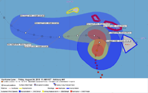
GOES West 30 minute lag near real-time Hurricane Lane animated Gifs (shown above)

425
WTPA32 PHFO 242051
TCPCP2
BULLETIN
Hurricane Lane Advisory Number 41
NWS Central Pacific Hurricane Center Honolulu HI EP142018
1100 AM HST Fri Aug 24 2018
…SLOW-MOVING LANE CONTINUING TO BRING FLOODING RAINFALL AND STRONG
GUSTY WINDS TO PARTS OF HAWAII…
SUMMARY OF 1100 AM HST…2100 UTC…INFORMATION
———————————————–
LOCATION…19.1N 157.9W
ABOUT 150 MI…245 KM S OF HONOLULU HAWAII
ABOUT 130 MI…205 KM WSW OF KAILUA-KONA HAWAII
MAXIMUM SUSTAINED WINDS…105 MPH…165 KM/H
PRESENT MOVEMENT…N OR 360 DEGREES AT 5 MPH…7 KM/H
MINIMUM CENTRAL PRESSURE…966 MB…28.53 INCHES
WATCHES AND WARNINGS
——————–
CHANGES WITH THIS ADVISORY:
The Hurricane Watch for Kauai has been changed to a Tropical Storm
Watch for Kauai and Niihau.
SUMMARY OF WATCHES AND WARNINGS IN EFFECT:
A Hurricane Warning is in effect for…
* Oahu
* Maui County…including the islands of Maui, Lanai, Molokai and
Kahoolawe
A Tropical Storm Warning is in effect for…
* Hawaii County
A Tropical Storm Watch is in effect for…
* Kauai County…including the islands of Kauai and Niihau
A Hurricane Warning means that hurricane conditions are expected
somewhere within the warning area. Preparations to protect life and
property should already be complete.
A Tropical Storm Warning means that tropical storm conditions are
expected somewhere within the warning area.
A Hurricane Watch means that hurricane conditions are possible
within the watch area.
A Tropical Storm Watch means that tropical storm conditions are
possible within the watch area.
Interests in the Northwestern Hawaiian Islands should monitor
the progress of Hurricane Lane.
For storm information specific to your area, please monitor
products issued by the National Weather Service office in
Honolulu Hawaii.
DISCUSSION AND OUTLOOK
———————-
At 1100 AM HST (2100 UTC), the center of Hurricane Lane was located
near latitude 19.1 North, longitude 157.9 West. Lane is moving
toward the north near 5 mph (7 km/h) and this general motion is
expected to continue through tonight. A turn toward the west is
anticipated on Saturday, with an increase in forward speed. The
center of Lane will remain dangerously close to portions of the
central Hawaiian islands later today and tonight.
Maximum sustained winds are near 105 mph (165 km/h) with higher
gusts. Weakening is forecast during the next 48 hours.
Hurricane-force winds extend outward up to 35 miles (55 km) from the
center and tropical-storm-force winds extend outward up to 140 miles
(220 km).
The estimated minimum central pressure is 966 mb (28.53 inches).
HAZARDS AFFECTING LAND
———————-
WIND: Tropical storm conditions are already occurring on the Big
Island, Maui County and Oahu. Hurricane conditions are expected over
portions of of Maui County and Oahu starting tonight. Tropical storm
conditions are possible on Kauai starting Saturday.
RAINFALL: Rain bands from Lane will continue to affect the main
Hawaiian Islands with excessive rainfall possible into the weekend.
These rains could lead to additional major flash flooding and
landslides. Lane is expected to produce total rain accumulations of
10 to 20 inches in some areas. Localized storm total amounts up to
40 inches are possible, mainly on the windward side of the Big
Island where over 30 inches of rain has already fallen in some
areas.
SURF: Very large swells generated by the slow moving hurricane will
severely impact the Hawaiian Islands into this weekend. These swells
will produce life-threatening and damaging surf along exposed
shorelines, particularly today through Saturday. In addition, a
prolonged period of extreme surf will also likely lead to
significant coastal erosion.
STORM SURGE: The combination of a dangerous storm surge and large
breaking waves will raise water levels by as much as 2 to 4 feet
above normal tide levels along south and west facing shores near
the center of Lane. The surge will be accompanied by large and
destructive waves.
NEXT ADVISORY
————-
Next intermediate advisory at 200 PM HST.
Next complete advisory at 500 PM HST.
$$
Forecaster R Ballard


Leave a Reply