
930
WTPA35 PHFO 110557
TCPCP5
BULLETIN
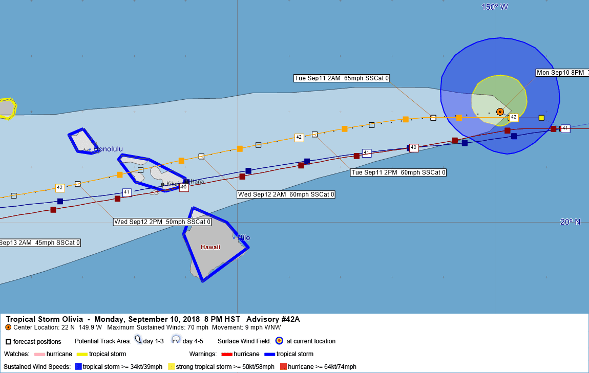
Tropical Storm Olivia Intermediate Advisory Number 42A
NWS Central Pacific Hurricane Center Honolulu HI EP172018
800 PM HST Mon Sep 10 2018
…OLIVIA DRAWING CLOSER TO THE MAIN HAWAIIAN ISLANDS…
SUMMARY OF 800 PM HST…0600 UTC…INFORMATION
———————————————-
LOCATION…22.0N 149.9W
ABOUT 365 MI…585 KM ENE OF HILO HAWAII
ABOUT 515 MI…830 KM E OF HONOLULU HAWAII
MAXIMUM SUSTAINED WINDS…70 MPH…110 KM/H
PRESENT MOVEMENT…WNW OR 290 DEGREES AT 9 MPH…15 KM/H
MINIMUM CENTRAL PRESSURE…991 MB…29.27 INCHES
WATCHES AND WARNINGS
——————–
CHANGES WITH THIS ADVISORY:
None.
SUMMARY OF WATCHES AND WARNINGS IN EFFECT:
A Tropical Storm Warning is in effect for…
* Oahu
* Maui County…including the islands of Maui, Molokai, Lanai, and
Kahoolawe
* Hawaii County
A Tropical Storm Watch is in effect for…
* Kauai County…including the islands of Kauai and Niihau.
A Tropical Storm Warning means that tropical storm conditions are
expected somewhere in the warning area within 36 hours.
A Tropical Storm Watch means that tropical storm conditions are
possible in the watch area within 48 hours.
For storm information specific to your area, please monitor
products issued by the National Weather Service office in
Honolulu Hawaii.
DISCUSSION AND OUTLOOK
———————-
At 800 PM HST (0600 UTC), the center of Tropical Storm Olivia was
located near latitude 22.0 North, longitude 149.9 West. Olivia is
moving toward the west-northwest near 9 mph (15 km/h). A turn to the
west and west-southwest is expected later tonight, with this
general motion continuing for the next couple of days. On the
forecast track, Olivia will be moving over the main Hawaiian Islands
late Tuesday night into Wednesday.
Maximum sustained winds are near 70 mph (110 km/h) with higher
gusts. Gradual weakening is forecast during the next 48 hours, but
Olivia is expected to remain a tropical storm as it moves across the
islands.
Tropical-storm-force winds extend outward up to 90 miles (150 km)
from the center.
The estimated minimum central pressure is 991 mb (29.27 inches).
HAZARDS AFFECTING LAND
———————-
WIND: Tropical storm conditions are expected over Maui County and
the Big Island starting late Tuesday or Tuesday night. Tropical
storm conditions are expected over Oahu starting late Tuesday night
or Wednesday morning. Tropical storm conditions are possible over
Kauai County starting Wednesday afternoon or evening.
RAINFALL: Olivia is expected to produce total rainfall accumulations
of 10 to 15 inches, with isolated maximum amounts of 20 inches
possible. This rainfall may produce life-threatening flash flooding.
SURF: Large swells generated by Olivia will impact the Hawaiian
Islands over the next couple of days. This will cause surf to
build, mainly along exposed east facing shores, and surf may become
damaging. See the High Surf Warning from National Weather Service
Honolulu for more information.
NEXT ADVISORY
————-
Next complete advisory at 1100 PM HST.
$$
Forecaster Birchard
390
WTPA45 PHFO 110315
TCDCP5
Tropical Storm Olivia Discussion Number 42
NWS Central Pacific Hurricane Center Honolulu HI EP172018
500 PM HST Mon Sep 10 2018
Air Force Reserve Hurricane Hunters indicated that Olivia was on a
slow weakening trend as they departed the tropical cyclone earlier
this afternoon. Bursts of convection have been occurring, but an
0058 UTC SSMI and 0155 UTC AMSU pass are showing disorganized
banding mainly to the northeast of the center. This seems to
indicate that Olivia is beginning to feel the effects of stronger
shear. There was a fairly wide spread of satellite intensity
estimates. However, used a blend of these along with the recent
reconnaissance data to come up with the intensity estimate of 60 kt.
Olivia has been moving 280/9 over the last few hours. This slightly
north-of-west motion may be due to the tropical cyclone beginning
to feel the effects of the increasing shear. All reliable track
guidance are unanimous in maintaining a westward motion overnight,
then a slightly south of due west motion is expected to begin in 12
to 24 hours, as a very strong deep layer ridge develops west of the
main Hawaiian Islands. Beyond 72 hours, an upper level low is
expected to develop to the north of Olivia and drop south. This
upper low is expected to impart a west-northwest motion on the
tropical cyclone, and in fact the two systems may merge in four to
five days, if enough of the low level circulation remains in the
face of strong shear.
Shear is expected to increase over the next 24 to 48 hours as
Olivia continues generally westward. Even though the sea surface
temperatures warm to greater than 28C along the track beyond 48
hours, the shear should allow weakening to continue. The intensity
guidance has been backing off on the weakening trend some in the 3
to 5 day time period, likely due to interaction with the upper low.
Toward the end of the forecast period, Olivia may be starting to
lose tropical characteristics.
KEY MESSAGES:
1. Resist the temptation to make comparisons between Hurricane
Lane and Hurricane Olivia. Although Lane was a stronger tropical
cyclone near the islands, it did not bring direct core impacts to
the state. In some areas, Olivia could bring significantly worse
impacts than were felt by Lane.
2. It is important to not focus on the exact forecast track and
intensity when planning for Olivia. Persons on the main Hawaiian
Islands should finish their preparations for direct impacts from
this system starting as early as Tuesday night. Those impacts could
include intense flooding rainfall, damaging winds, and large and
dangerous surf.
3. Regardless of the exact track and intensity that Olivia takes
as it approaches the islands, significant effects often extend far
from the center. In particular, the mountainous terrain of Hawaii
can produce localized areas of strongly enhanced wind gusts and
rainfall, even well away from the tropical cyclone center.
FORECAST POSITIONS AND MAX WINDS
INIT 11/0300Z 21.9N 149.7W 60 KT 70 MPH
12H 11/1200Z 21.9N 151.2W 55 KT 65 MPH
24H 12/0000Z 21.6N 153.5W 50 KT 60 MPH
36H 12/1200Z 21.2N 155.7W 50 KT 60 MPH
48H 13/0000Z 20.7N 158.1W 45 KT 50 MPH
72H 14/0000Z 20.1N 163.1W 40 KT 45 MPH
96H 15/0000Z 20.7N 167.8W 35 KT 40 MPH
120H 16/0000Z 22.5N 173.5W 30 KT 35 MPH
$$
Forecaster R Ballard


Leave a Reply