WTPA35 PHFO 311439
TCPCP5
BULLETIN
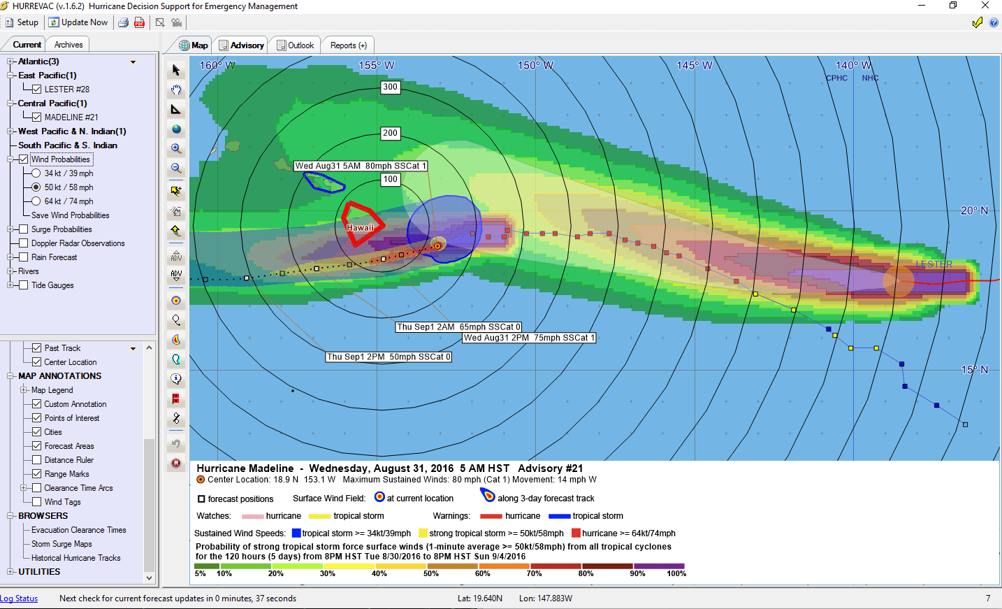
HURRICANE MADELINE ADVISORY NUMBER 21
NWS CENTRAL PACIFIC HURRICANE CENTER HONOLULU HI EP142016
500 AM HST WED AUG 31 2016
…MADELINE WEAKENS AS IT DRAWS CLOSER TO HAWAII…
…STILL A CATEGORY ONE HURRICANE…
SUMMARY OF 500 AM HST…1500 UTC…INFORMATION
———————————————-
LOCATION…18.9N 153.1W
ABOUT 140 MI…230 KM ESE OF HILO HAWAII
ABOUT 355 MI…565 KM ESE OF HONOLULU HAWAII
MAXIMUM SUSTAINED WINDS…80 MPH…130 KM/H
PRESENT MOVEMENT…W OR 260 DEGREES AT 14 MPH…22 KM/H
MINIMUM CENTRAL PRESSURE…988 MB…29.18 INCHES
WATCHES AND WARNINGS
——————–
CHANGES WITH THIS ADVISORY:
A Tropical Storm Warning has been issued for Maui County, including
the islands of Maui, Molokai, Lanai and Kahoolawe.
SUMMARY OF WATCHES AND WARNINGS IN EFFECT:
A Hurricane Warning is in effect for…
* Hawaii County
A Tropical Storm Warning is in effect for…
* Maui County including the islands of Maui, Molokai, Lanai and
Kahoolawe
A Hurricane Warning means that hurricane conditions are expected
somewhere within the warning area. A Tropical Storm Warning means
that tropical storm conditions are expected somewhere within the
watch area. Preparations to protect life and property should be
rushed to completion.
For storm information specific to your area, please monitor
products issued by the National Weather Service office in
Honolulu Hawaii.
DISCUSSION AND 48-HOUR OUTLOOK
——————————
At 500 AM HST (1500 UTC), the center of Hurricane Madeline was
located near latitude 18.9 North, longitude 153.1 West. Madeline is
moving toward the west near 14 mph (22 km/h) and this general motion
is expected to continue for the next couple of days. On the forecast
track, the center of Madeline will pass dangerously close to the
Big Island later today.
Maximum sustained winds are near 80 mph (130 km/h) with higher
gusts. Steady weakening is forecast during the next 48 hours, and
Madeline is forecast to weaken to a tropical storm tonight or
Thursday.
Hurricane-force winds extend outward up to 10 miles (20 km) from the
center and tropical-storm-force winds extend outward up to 125 miles
(205 km).
The estimated minimum central pressure is 988 mb (29.18 inches).
HAZARDS AFFECTING LAND
———————-
WIND: Hurricane conditions are expected to develop over Hawaii
County later today, continuing into early Thursday. Tropical storm
conditions are expected to develop over Maui County later today,
continuing into early Thursday.
SURF: Swells generated by Madeline are expected to increase in
Hawaiian waters today, possibly becoming damaging along east
facing shores of Hawaii County and the Island of Maui today and
tonight.
RAIN: Madeline is expected to produce total rain accumulations of 5
to 10 inches, with isolated maximum amounts near 15 inches, across
Hawaii County, especially over windward portions. Total rainfall
accumulations of 1 to 3 inches, with isolated maximum amounts up to
4 inches, can be expected in the islands of Maui County. This
rainfall may lead to dangerous flash floods and mudslides.
STORM SURGE: Depending on the track of Madeline, the combination of
storm surge and tides could cause normally dry areas near the coast
to become flooded. The water could reach 1 to 3 feet above ground if
peak surge were to coincide with high tide. The surge would be
accompanied by large damaging surf and can vary over short
distances.
NEXT ADVISORY
————-
Next intermediate advisory at 800 AM HST.
Next complete advisory at 1100 AM HST.
$$
Forecaster Birchard
————————————————————
The NHC Discussion Bulletin had not yet been transmitted by NHC
at the time the NHC Public Advisory bulletin was received. This file
will be updated in a few minutes when the NHC Discussion Bulletin
is received from NHC.
————————————————————


Leave a Reply