WTPA35 PHFO 310241
TCPCP5
BULLETIN
HURRICANE MADELINE ADVISORY NUMBER 18
NWS CENTRAL PACIFIC HURRICANE CENTER HONOLULU HI EP142016
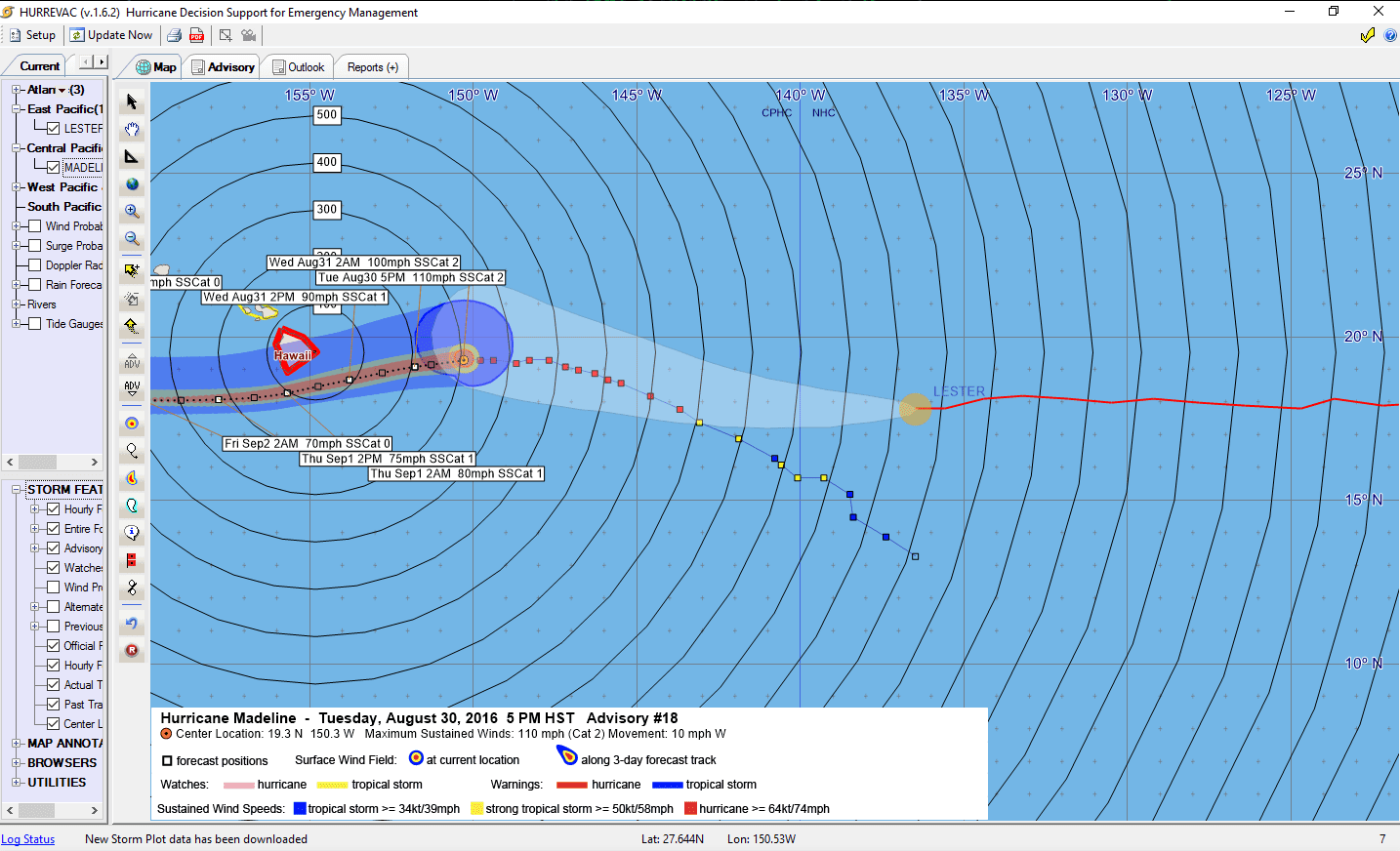
500 PM HST TUE AUG 30 2016
…DANGEROUS HURRICANE MADELINE TRACKING WESTWARD TOWARDS HAWAII…
SUMMARY OF 500 PM HST…0300 UTC…INFORMATION
———————————————-
LOCATION…19.3N 150.3W
ABOUT 315 MI…505 KM E OF HILO HAWAII
ABOUT 510 MI…825 KM ESE OF HONOLULU HAWAII
MAXIMUM SUSTAINED WINDS…110 MPH…175 KM/H
PRESENT MOVEMENT…W OR 270 DEGREES AT 10 MPH…17 KM/H
MINIMUM CENTRAL PRESSURE…972 MB…28.71 INCHES
WATCHES AND WARNINGS
——————–
CHANGES WITH THIS ADVISORY:
None.
SUMMARY OF WATCHES AND WARNINGS IN EFFECT:
A Hurricane Warning is in effect for…
* Hawaii County.
A Tropical Storm Watch is in effect for…
* Maui County including the islands of Maui, Molokai, and Lanai
A Hurricane Warning means that hurricane conditions are expected
somewhere within the warning area. A warning is typically issued
36 hours before the anticipated first occurrence of tropical
storm force winds, which make outside preparations difficult or
dangerous. Preparations to protect life and property should be
rushed to completion.
A Tropical Storm Watch means that tropical storm conditions are
possible within the watch area within 48 hours.
Interests elsewhere in the main Hawaiian Islands should monitor
the progress of Madeline.
For storm information specific to your area, please monitor
products issued by the National Weather Service office in
Honolulu, Hawaii.
DISCUSSION AND 48-HOUR OUTLOOK
——————————
At 500 PM HST (0300 UTC), the center of Hurricane Madeline was
located near latitude 19.3 North, longitude 150.3 West. Madeline is
moving toward the west near 10 mph (17 km/h). This motion is
expected to continue into the evening, followed by a turn toward the
west-southwest tonight through Thursday. On the forecast track, the
center of Madeline will pass dangerously close to Hawaii County
Wednesday and Wednesday night.
Maximum sustained winds are near 110 mph (175 km/h) with higher
gusts. Gradual weakening is forecast during the next 48 hours.
However, Madeline is expected to be at hurricane strength when it
passes near Hawaii County.
Hurricane-force winds extend outward up to 25 miles (35 km) from the
center and tropical-storm-force winds extend outward up to 125 miles
(205 km).
The estimated minimum central pressure is 972 mb (28.71 inches).
HAZARDS AFFECTING LAND
———————-
WIND: Hurricane conditions are expected to develop over Hawaii
County as early as late Wednesday and continue into early Thursday.
Tropical storm conditions are possible over Maui County, including
the islands of Maui Molokai and Lanai, on Wednesday into early
Thursday.
SURF: Swells generated by Madeline are expected to build from east
to west across the Hawaiian Islands later today and tonight,
possibly becoming damaging along east facing shorelines of Hawaii
County and eastern portions of the Island of Maui on Wednesday into
Thursday.
RAIN: Heavy rains associated with Madeline are expected to reach
Hawaii County on Wednesday, and may impact other Hawaiian Islands
later Wednesday through Thursday. Madeline is expected to produce
total rain accumulations of 5 to 10 inches, with isolated maximum
amounts near 15 inches, across the Big Island, especially over
windward portions. This rainfall may lead to dangerous flash floods
and mudslides. Madeline may produce up to 4 inches of rainfall
across Maui County.
STORM SURGE: Depending on the track of Madeline, the combination of
storm surge and tides could cause normally dry areas near the coast
to become flooded. The water could reach 1 to 3 feet above ground if
peak surge were to coincide with high tide. The surge would be
accompanied by large damaging surf and can vary over short
distances.
NEXT ADVISORY
————-
Next intermediate advisory at 800 PM HST.
Next complete advisory at 1100 PM HST.
$$
Forecaster Wroe
WTPA45 PHFO 310251
TCDCP5
HURRICANE MADELINE DISCUSSION NUMBER 18
NWS CENTRAL PACIFIC HURRICANE CENTER HONOLULU HI EP142016
500 PM HST TUE AUG 30 2016
Under the presence of continued vertical wind shear, the satellite
presentation of Madeline has continued to gradually degrade today,
as an eye is no longer present. While Dvorak final T numbers
continue to drop, current intensity estimates range from 5.5/102 kt
at HFO to 5.0/90 kt out of JTWC and SAB, and CIMSS ADT has fallen
below 80 kt. Since Air Force reconnaissance aircraft reported
stronger than expected winds earlier in the day, the current
intensity will be set at 95 kt for this advisory. The Air Force
reconnaissance aircraft will fly another mission in Madeline this
evening.
The initial motion for this advisory remains due west at 270/09 kt.
Madeline continues to move westward along the southern edge of a low
to mid level ridge, while a shallow upper level trough continues to
dig toward the hurricane from the northwest. The ridge will keep
Madeline on a westward-moving track into the evening, followed by a
gradual turn toward the west-southwest tonight and Wednesday as the
mid level ridge strengthens to the north and northwest and the upper
level trough imparts northwesterly winds in the high levels of the
cyclone. This track will take the center of Madeline dangerously
close to the Big Island of Hawaii (Hawaii County) late Wednesday
into Thursday, and a Hurricane Warning remains in place for the Big
Island, given the very close approach of Madeline and uncertainty in
the track forecast. On Friday Madeline is forecast to turn back
toward the west as the upper level trough digs southward over
Hawaii. The official forecast track has changed little from the
prior advisory and is near TVCN, which lies in the middle of a
rather tightly clustered reliable guidance envelope during the next
three days. The guidance envelope spreads beyond day three, while
the GFDL remains the northern outlier through the entire forecast
duration.
Madeline is expected to gradually weaken through the next four days
as the upper level trough digs southward and continues to impart
vertical wind shear. UW CIMSS estimates current vertical wind shear
from the west-southwest at 14 kt, and SHIPS forecasts shear to
gradually increase during the next 24 to 36 hours before relaxing
on Friday. The official intensity forecast calls for gradual
weakening during this time that follows the trends of SHIPS and
IVCN, though at a slightly slower rate of weakening than the
guidance through Friday. Although it will be weakening, Madeline is
expected to remain a dangerous hurricane as it passes near the Big
Island of Hawaii late Wednesday into early Thursday.
We would like to remind everyone that hazards associated with
hurricanes can extend well away from the center, and you should
not focus too closely on the exact forecast track, as small changes
can lead to differences in impacts.
FORECAST POSITIONS AND MAX WINDS
INIT 31/0300Z 19.3N 150.3W 95 KT 110 MPH
12H 31/1200Z 19.1N 151.8W 85 KT 100 MPH
24H 01/0000Z 18.7N 153.8W 80 KT 90 MPH
36H 01/1200Z 18.3N 155.7W 70 KT 80 MPH
48H 02/0000Z 18.1N 157.8W 65 KT 75 MPH
72H 03/0000Z 18.2N 162.7W 60 KT 70 MPH
96H 04/0000Z 18.7N 168.2W 55 KT 65 MPH
120H 05/0000Z 19.0N 173.2W 55 KT 65 MPH
$$
Forecaster Wroe


Leave a Reply