BULLETIN
HURRICANE MATTHEW INTERMEDIATE ADVISORY NUMBER 36A
NWS NATIONAL HURRICANE CENTER MIAMI FL AL142016
200 AM EDT FRI OCT 07 2016
…EYE OF EXTREMELY DANGEROUS HURRICANE MATTHEW MOVING CLOSER TO THE
EAST COAST OF FLORIDA…
SUMMARY OF 200 AM EDT…0600 UTC…INFORMATION
———————————————-
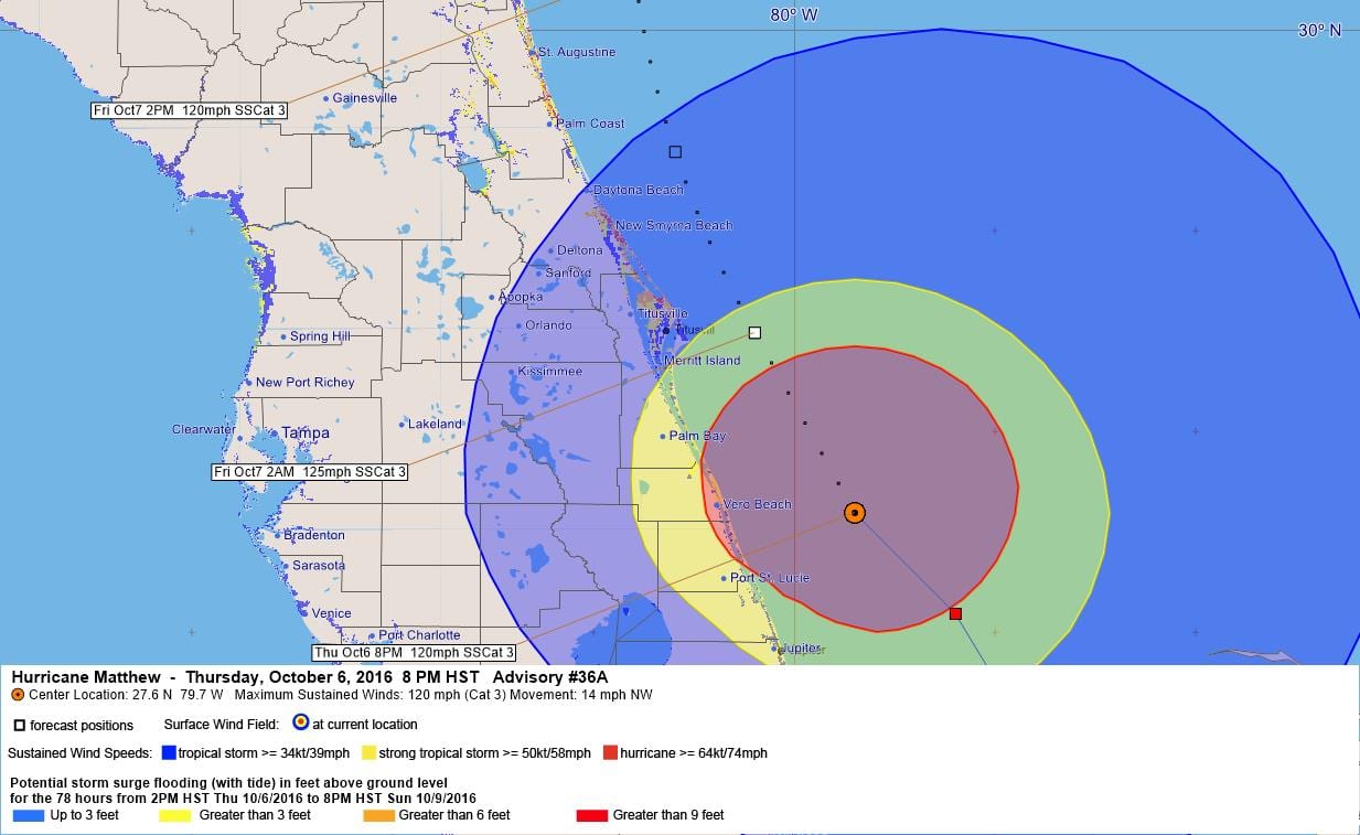
LOCATION…27.6N 79.7W
ABOUT 45 MI…70 KM E OF VERO BEACH FLORIDA
ABOUT 80 MI…125 KM SE OF CAPE CANAVERAL FLORIDA
MAXIMUM SUSTAINED WINDS…120 MPH…195 KM/H
PRESENT MOVEMENT…NW OR 325 DEGREES AT 14 MPH…22 KM/H
MINIMUM CENTRAL PRESSURE…938 MB…27.70 INCHES
WATCHES AND WARNINGS
——————–
CHANGES WITH THIS ADVISORY:
None.
SUMMARY OF WATCHES AND WARNINGS IN EFFECT:
A Hurricane Warning is in effect for…
* Northwestern Bahamas, including the Abacos, Andros Island, Berry
Islands, Bimini, Eleuthera, Grand Bahama Island, and New Providence
* Boca Raton to South Santee River
* Lake Okeechobee
A Tropical Storm Warning is in effect for…
* Ocean Reef to south of Boca Raton
* Anclote River to Suwannee River
* North of South Santee River to Surf City
A Tropical Storm Watch is in effect for…
* Englewood to Anclote River
Interests elsewhere in the Florida Peninsula and in the Carolinas
should monitor the progress of Matthew.
A Hurricane Warning means that hurricane conditions are expected
somewhere within the warning area. A warning is typically issued
36 hours before the anticipated first occurrence of tropical-storm-
force winds, conditions that make outside preparations difficult or
dangerous. Preparations to protect life and property should be
rushed to completion.
A Tropical Storm Warning means that tropical storm conditions are
expected somewhere within the warning area within 36 hours.
For storm information specific to your area in the United
States, including possible inland watches and warnings, please
monitor products issued by your local National Weather Service
forecast office. For storm information specific to your area outside
the United States, please monitor products issued by your national
meteorological service.
DISCUSSION AND 48-HOUR OUTLOOK
——————————
At 200 AM EDT (0600 UTC), the eye of Hurricane Matthew was located
by NOAA Doppler weather radars and an Air Force Reserve Hurricane
Hunter aircraft near latitude 27.6 North, longitude 79.7 West.
Matthew is moving toward the northwest near 14 mph (22 km/h). A turn
toward the north-northwest is expected later today, and a turn
toward the north is expected tonight or Saturday. On the forecast
track, the center of Matthew will be moving near or over the east
coast of the Florida peninsula through tonight, and near or over the
coasts of Georgia and South Carolina on Saturday.
Maximum sustained winds have decreased to near 120 mph (195 km/h)
with higher gusts. Matthew is a category 3 hurricane on the
Saffir-Simpson Hurricane Wind Scale. Although some additional
weakening is forecast during the next 48 hours, Matthew is expected
to be a powerful category 3 hurricane as it moves near the coast of
Florida.
Hurricane-force winds extend outward up to 60 miles (95 km) from
the center and tropical-storm-force winds extend outward up to 185
miles (295 km). During the past hour, a wind gust to 70 mph (113
km/h) was reported at Vero Beach, Florida, and a gust to 60 mph
occurred at Melbourne, Florida.
The latest minimum central pressure reported by the reconnaissance
aircraft was 938 mb (27.70 inches).
HAZARDS AFFECTING LAND
———————-
WIND: Hurricane conditions should diminish over portions of the
northwestern Bahamas this morning.
Hurricane conditions are expected to first reach the hurricane
warning area in Florida during the next several hours and will
spread northward within the warning area through today. Tropical
storm conditions will continue to spread northward in the warning
area along the Florida east coast today.
Hurricane conditions are expected to spread northward in the warning
area in Georgia and South Carolina tonight and Saturday with
tropical storm conditions expected later today.
Winds increase rapidly in elevation in a tropical cyclone.
Residents in high-rise buildings should be aware that the winds at
the top of a 30-story building will be, on average, about one
Saffir-Simpson category higher than the winds near the surface.
Tropical storm conditions are expected in the tropical storm warning
area in the Carolinas on tonight and Saturday.
STORM SURGE: The combination of a dangerous storm surge and large
and destructive waves could raise water levels by as much as the
following amounts above normal tide levels…
Northwestern Bahamas…10 to 15 feet
The water could reach the following heights above ground if the peak
surge occurs at the time of high tide…
Sebastian Inlet, Florida, to Edisto Beach, South Carolina, including
portions of the St. Johns River…7 to 11 ft
Edisto Beach to South Santee River, South Carolina…4 to 6 ft
Boca Raton to Sebastian Inlet, Florida…4 to 6 ft
South Santee River, South Carolina, to Cape Fear, North Carolina…2
to 4 ft
Virginia Key to Boca Raton, Florida…1 to 3 ft
Surge-related flooding depends on the relative timing of the surge
and the tidal cycle, and can vary greatly over short distances.
Large waves generated by Matthew will cause water rises to occur
well in advance of and well away from the track of the center.
The combination of a dangerous storm surge and the tide will cause
normally dry areas near the coast to be flooded by rising waters
moving inland from the shoreline. There is a danger of life-
threatening inundation during the next 36 hours along the Florida
east coast, the Georgia coast, and the South Carolina coast from
Boca Raton, Florida, to South Santee River, South Carolina.
There is the possibility of life-threatening inundation during the
next 48 hours from north of South Santee River, South Carolina, to
Cape Fear, North Carolina. For a depiction of areas at risk, please
see the Prototype National Weather Service Storm Surge Watch/Warning
Graphic. For information specific to your area, please see products
issued by your local National Weather Service forecast office.
The Prototype Storm Surge Watch/Warning Graphic is a depiction of
areas that would qualify for inclusion under a storm surge watch or
warning currently under development by the National Weather Service
and planned for operational use in 2017. The Prototype Graphic is
available at hurricanes.gov.
RAINFALL: Matthew is expected to produce total rainfall amounts in
the following areas:
The northern Bahamas…8 to 12 inches, isolated 15 inches
The Atlantic coast of the United States from Central Florida to
eastern North Carolina…6 to 12 inches with isolated totals near
15 inches along the coasts
TORNADOES: An isolated tornado or two is possible along the
east-central Florida coast tonight.
SURF: Swells generated by Matthew will continue to affect portions
of the north coast of Cuba and the Bahamas during the next few days,
and will spread northward along the east coast of Florida and the
southeast U.S. coast through the weekend. These swells will likely
cause life-threatening surf and rip current conditions. Please
consult products from your local weather office.
NEXT ADVISORY
————-
Next complete advisory at 500 AM EDT.
$$
Forecaster Stewart
000
WTNT44 KNHC 070257
HURRICANE MATTHEW DISCUSSION NUMBER 36
NWS NATIONAL HURRICANE CENTER MIAMI FL AL142016
1100 PM EDT THU OCT 06 2016
The satellite appearance of Matthew has improved during the past
several hours, with an eye embedded within a more circular central
dense overcast and an increase in the outer banding. Reports from
a NOAA Hurricane Hunter aircraft and coastal radar data show the
presence of centric eyewalls with diameters of about 8 and 60 n mi
respectively. The NOAA aircraft earlier reported a minimum pressure
of 937 mb, and an Air Force Reserve Hurricane Hunter just reported
estimated surface winds of 109 kt from the SFMR and a pressure of
939 mb. Based on these data, the initial intensity is 115 kt.
The initial motion is 325/11 kt. For the next 24-48 hours, Matthew
should move around the western end of the subtropical ridge, with
the motion gradually turning northward and then northeastward.
During this time, the center of the guidance envelope and the
various consensus models have shifted a little to the east. However,
the ECMWF, GFS, and UKMET continue to suggest the possibility of the
hurricane making landfall in Florida and then moving near the coasts
of Georgia and South Carolina. This part of the forecast is nudged
a little to the east and lies between the model consensus and the
previous forecast. After 48 hours, a mid- to upper-level ridge is
forecast to build north and west of Matthew, and the track guidance
forecasts a southeasterly to southerly motion in response. While
there is still a large spread, the GFS, ECMWF, and UKMET are in
better agreement that Matthew should move south between the ridge
and Hurricane Nicole to the east. This part of the forecast follows
this guidance and lies between the GFS and ECMWF.
During the next 12-24 hours, Matthew will likely weaken a little as
it undergoes an eyewall replacement cycle. After that time, it is
expected to encounter strong southwesterly vertical shear, and later
in the forecast period dry air is likely to entrain into the
cyclone. This combination should cause steady weakening, and
Matthew is forecast to drop below hurricane strength by 72 hours.
The new intensity forecast is in best agreement with the SHIPS
model.
KEY MESSAGES:
1. Matthew is likely to produce devastating impacts from storm
surge, extreme winds, and heavy rains in the northwestern Bahamas
today, and along extensive portions of the east coast of Florida
tonight.
2. Evacuations are not just a coastal event. Strong winds will
occur well inland from the coast, and residents of mobile
homes under evacuation orders are urged to heed those orders.
3. Hurricane winds increase very rapidly with height, and residents
of high-rise buildings are at particular risk of strong winds. Winds
at the top of a 30-story building will average one Saffir-Simpson
category higher than the winds near the surface.
4. When a hurricane is forecast to take a track roughly parallel to
a coastline, as Matthew is forecast to do from Florida through South
Carolina, it becomes very difficult to specify impacts at any one
location. Only a small deviation of the track to the left of the
NHC forecast could bring the core of a major hurricane onshore
within the hurricane warning area in Florida and Georgia. Modest
deviations to the right could keep much of the hurricane-force winds
offshore. Similarly large variations in impacts are possible in the
hurricane watch and warning areas in northeast Georgia and South
Carolina.
5. The National Hurricane Center is issuing Potential Storm Surge
Flooding Maps, and Prototype Storm Surge Watch/Warning Graphics for
Matthew. It is important to remember that the Potential Storm Surge
Flooding Map does not represent a forecast of expected inundation,
but rather depicts a reasonable worst-case scenario — the amount of
inundation that has a 10 percent chance of being exceeded.
FORECAST POSITIONS AND MAX WINDS
INIT 07/0300Z 27.1N 79.2W 115 KT 130 MPH
12H 07/1200Z 28.5N 80.2W 110 KT 125 MPH
24H 08/0000Z 30.3N 80.8W 105 KT 120 MPH
36H 08/1200Z 31.8N 80.2W 90 KT 105 MPH
48H 09/0000Z 32.6N 78.7W 75 KT 85 MPH
72H 10/0000Z 31.5N 75.5W 60 KT 70 MPH
96H 11/0000Z 29.0N 75.5W 50 KT 60 MPH
120H 12/0000Z 27.0N 77.0W 40 KT 45 MPH
$$
Forecaster Beven


Leave a Reply