000
WTNT34 KNHC 071156
BULLETIN
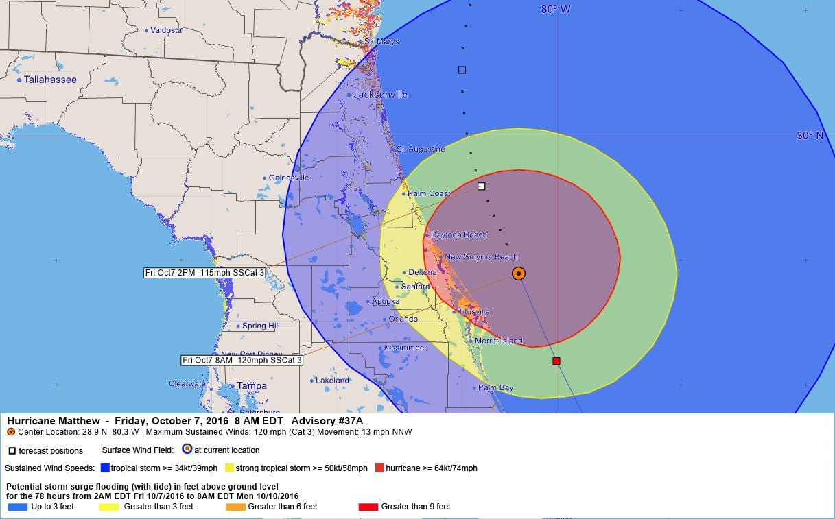
HURRICANE MATTHEW INTERMEDIATE ADVISORY NUMBER 37A
NWS NATIONAL HURRICANE CENTER MIAMI FL AL142016
800 AM EDT FRI OCT 07 2016
…EYEWALL OF DANGEROUS HURRICANE MATTHEW HUGGING THE COAST OF
CENTRAL FLORIDA…
SUMMARY OF 800 AM EDT…1200 UTC…INFORMATION
———————————————-
LOCATION…28.9N 80.3W
ABOUT 35 MI…55 KM NNE OF CAPE CANAVERAL FLORIDA
ABOUT 45 MI…75 KM ESE OF DAYTONA BEACH FLORIDA
MAXIMUM SUSTAINED WINDS…120 MPH…195 KM/H
PRESENT MOVEMENT…NNW OR 330 DEGREES AT 13 MPH…20 KM/H
MINIMUM CENTRAL PRESSURE…944 MB…27.86 INCHES
WATCHES AND WARNINGS
——————–
CHANGES WITH THIS ADVISORY:
The Tropical Storm Warning along the east coast of Florida south
of Jupiter Inlet has been discontinued.
The Hurricane Warning from north of Jupiter Inlet to Sebastian Inlet
has been changed to a Tropical Storm Warning.
The government of the Bahamas has discontinued the Hurricane Warning
for the Bahamas.
SUMMARY OF WATCHES AND WARNINGS IN EFFECT:
A Hurricane Warning is in effect for…
* Sebastian Inlet to South Santee River
A Tropical Storm Warning is in effect for…
* Jupiter Inlet to Sebastian Inlet
* Anclote River to Suwannee River
* North of South Santee River to Surf City
A Tropical Storm Watch is in effect for…
* Anna Maria Island to Anclote River
Interests elsewhere in the Florida Peninsula and in the Carolinas
should monitor the progress of Matthew.
For storm information specific to your area in the United States,
including possible inland watches and warnings, please monitor
products issued by your local National Weather Service forecast
office.
DISCUSSION AND 48-HOUR OUTLOOK
——————————
At 800 AM EDT (1200 UTC), the eye of Hurricane Matthew was located
near latitude 28.9 North, longitude 80.3 West. Matthew is moving
toward the north-northwest near 13 mph (20 km/h), and this general
motion is expected to continue today. A turn toward the north is
expected tonight or Saturday. On the forecast track, the center of
Matthew will be moving near or over the east coast of the Florida
peninsula through tonight, and near or over the coasts of Georgia
and South Carolina on Saturday.
Maximum sustained winds are near 120 mph (195 km/h) with higher
gusts. Matthew is a category 3 hurricane on the Saffir-Simpson
Hurricane Wind Scale. Although weakening is forecast during the
next 48 hours, Matthew is expected to be a category 3 hurricane as
it moves near the coast of Florida today.
Hurricane-force winds extend outward up to 60 miles (95 km) from
the center, and tropical-storm-force winds extend outward up to 185
miles (295 km). Cape Canaveral recently reported and wind gust to
97 mph (155 km/h), and Daytona Beach reported a wind gust of 67 mph
(110 km/h).
The latest minimum central pressure reported by the reconnaissance
aircraft was 944 mb (27.86 inches).
HAZARDS AFFECTING LAND
———————-
WIND: Hurricane and tropical storm conditions are expected to
continue over the warning area in Florida during the next several
hours, and spread northward within the warning area through today.
Tropical storm conditions will continue to spread northward in the
warning area along the Florida west coast today.
Hurricane conditions are expected to spread northward in the warning
area in Georgia and South Carolina tonight and Saturday with
tropical storm conditions expected later today.
Winds increase rapidly in elevation in a tropical cyclone.
Residents in high-rise buildings should be aware that the winds at
the top of a 30-story building will be, on average, about one
Saffir-Simpson category higher than the winds near the surface.
Tropical storm conditions are expected in the tropical storm warning
area in the Carolinas tonight and Saturday.
STORM SURGE: The combination of a dangerous storm surge, the tide,
and large and destructive waves will cause normally dry areas near
the coast to be flooded by rising waters moving inland from the
shoreline. The water could reach the following heights above ground
if the peak surge occurs at the time of high tide…
Sebastian Inlet, Florida, to Edisto Beach, South Carolina, including
portions of the St. Johns River…7 to 11 ft
Edisto Beach to South Santee River, South Carolina…4 to 6 ft
Jupiter Inlet to Sebastian Inlet, Florida…4 to 6 ft
South Santee River, South Carolina, to Cape Fear, North Carolina…2
to 4 ft
The deepest water will occur along the immediate coast in areas of
onshore winds. Surge-related flooding depends on the relative
timing of the surge and the tidal cycle, and can vary greatly over
short distances. Large waves generated by Matthew will cause water
rises to occur well in advance of and well away from the track of
the center. For information specific to your area, please see
products issued by your local National Weather Service forecast
office.
Water levels in the northwestern Bahamas should continue to subside
during the day.
There is a danger of life-threatening inundation during the next 36
hours along the Florida east coast, the Georgia coast, and the South
Carolina coast from Jupiter Inlet, Florida, to South Santee River,
South Carolina. There is the possibility of life-threatening
inundation during the next 48 hours from north of South Santee
River, South Carolina, to Cape Fear, North Carolina. For a depiction
of areas at risk, please see the Prototype National Weather Service
Storm Surge Watch/Warning Graphic. For information specific to your
area, please see products issued by your local National Weather
Service forecast office.
The Prototype Storm Surge Watch/Warning Graphic is a depiction of
areas that would qualify for inclusion under a storm surge watch or
warning currently under development by the National Weather Service
and planned for operational use in 2017. The Prototype Graphic is
available at hurricanes.gov.
RAINFALL: Matthew is expected to produce total rain accumulations of
8 to 12 inches over the Atlantic coast of the United States from
central Florida to eastern North Carolina…with possible isolated
maximum amounts of 15 inches. This rainfall may result in flooding
and flash flooding.
TORNADOES: An isolated tornado or two is possible along the
east-central Florida coast today.
SURF: Swells generated by Matthew will continue to affect portions
of the Bahamas and the east coast of Florida during the next few
days, and will spread northward along the southeast U.S. coast
through the weekend. These swells will likely cause
life-threatening surf and rip current conditions. Please consult
products from your local weather office.
NEXT ADVISORY
————-
Next complete advisory at 1100 AM EDT.
$$
Forecaster Avila
000
WTNT44 KNHC 070857
HURRICANE MATTHEW DISCUSSION NUMBER 37
NWS NATIONAL HURRICANE CENTER MIAMI FL AL142016
500 AM EDT FRI OCT 07 2016
The satellite appearance of Matthew has become rather disheveled
looking in infrared satellite imagery since the previous advisory.
Land-based Doppler radar data indicate that Matthew has been going
through an eyewall replacement cycle for the past 12 hours or so,
but the inner eyewall has yet to dissipate within the 35-40 nmi wide
outer eyewall. Both Doppler velocity data and recon SFMR surface
winds and flight-level winds indicate that hurricane-force winds are
and have been occuring within the outer eyewall just 5-10 nmi east
of the Florida coastline. Although the central pressure has
remained steady between 938-940 mb, the intensity has been lowered
to 105 kt based on 700-mb flight-level winds of 118 kt and several
patches of Doppler velocities of 120-122 kt between 5000-7500 feet.
The initial motion estimate is 330/12 kt. For the next 48 hours,
Matthew is expected to move northward and then northeastward around
the western periphery of a deep-layer subtropical ridge. After that
time, a weakening Matthew is expected to turn slowly southeastward
and then southward as the cyclone gets cut off from the influence of
the mid-latitude westerlies and becomes embedded within the
aforementioned large-scale high pressure ridge. The latest model
guidance has shifted to the left of the previous forecast track
after 36 hours, and the official forecast has been nudged in that
direction, but remains well to the right of the model consensus and
close to the GFS-ECMWF consensus.
Matthew is expected to slowly weaken some more during the next 12
hours or so while the cyclone completes the eyewall replacement
cycle. By 24 hours and beyond, more significant weakening is
expected due to the combination of strong southwesterly vertical
shear increasing to more than 30 kt and entrainment of very dry
mid-level air with humidity values less than 20 percent. The new
intensity forecast closely follows the consensus model IVCN.
Special thanks to the Air Force Reserve and NOAA Hurricane Hunters
for their tireless efforts in having already completed more than 90
center or eye fixes.
KEY MESSAGES:
1. Matthew is likely to produce devastating impacts from storm
surge, extreme winds, and heavy rains along extensive portions of
the east-central and northeast coast of Florida today.
2. Evacuations are not just a coastal event. Strong winds will
occur well inland from the coast, and residents of mobile
homes under evacuation orders are urged to heed those orders.
3. Hurricane winds increase very rapidly with height, and residents
of high-rise buildings are at particular risk of strong winds. Winds
at the top of a 30-story building will average one Saffir-Simpson
category higher than the winds near the surface.
4. When a hurricane is forecast to take a track roughly parallel to
a coastline, as Matthew is forecast to do from Florida through South
Carolina, it becomes very difficult to specify impacts at any one
location. Only a small deviation of the track to the left of the
NHC forecast could bring the core of a major hurricane onshore
within the hurricane warning area in Florida and Georgia. Modest
deviations to the right could keep much of the hurricane-force winds
offshore. Similarly large variations in impacts are possible in the
hurricane watch and warning areas in northeast Georgia and South
Carolina.
5. The National Hurricane Center is issuing Potential Storm Surge
Flooding Maps, and Prototype Storm Surge Watch/Warning Graphics for
Matthew. It is important to remember that the Potential Storm Surge
Flooding Map does not represent a forecast of expected inundation,
but rather depicts a reasonable worst-case scenario — the amount of
inundation that has a 10 percent chance of being exceeded.
FORECAST POSITIONS AND MAX WINDS
INIT 07/0900Z 28.2N 80.0W 105 KT 120 MPH
12H 07/1800Z 29.6N 80.6W 100 KT 115 MPH
24H 08/0600Z 31.5N 80.5W 90 KT 105 MPH
36H 08/1800Z 32.6N 79.2W 80 KT 90 MPH
48H 09/0600Z 33.1N 77.7W 65 KT 75 MPH
72H 10/0600Z 31.5N 74.5W 50 KT 60 MPH
96H 11/0600Z 29.0N 75.0W 40 KT 45 MPH
120H 12/0600Z 27.0N 76.5W 35 KT 40 MPH
$$
Forecaster Stewart


Leave a Reply