

000
WTNT34 KNHC 080258
BULLETIN
HURRICANE MATTHEW ADVISORY NUMBER 40
NWS NATIONAL HURRICANE CENTER MIAMI FL AL142016
1100 PM EDT FRI OCT 07 2016
…EYE OF HURRICANE MATTHEW CONTINUING NORTHWARD JUST OFF OF THE
COAST OF GEORGIA…
…STORM SURGE FLOODING CONTINUES IN FLORIDA AND GEORGIA…
SUMMARY OF 1100 PM EDT…0300 UTC…INFORMATION
———————————————–
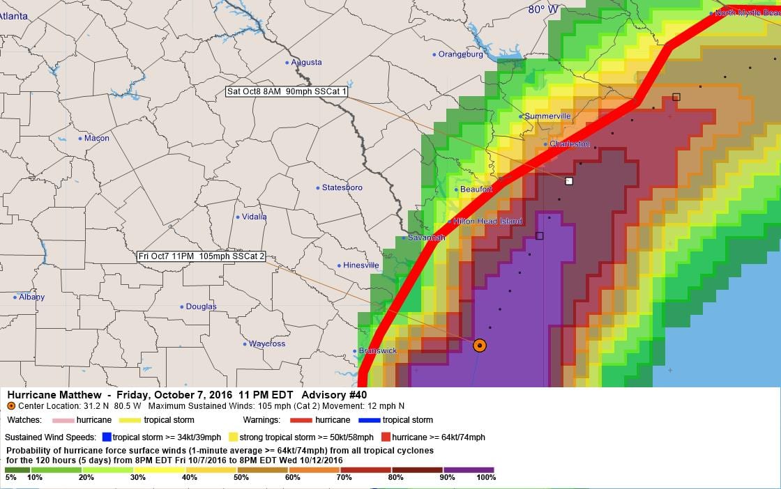
LOCATION…31.2N 80.5W
ABOUT 70 MI…115 KM SSE OF SAVANNAH GEORGIA
ABOUT 115 MI…185 KM SSW OF CHARLESTON SOUTH CAROLINA
MAXIMUM SUSTAINED WINDS…105 MPH…165 KM/H
PRESENT MOVEMENT…N OR 10 DEGREES AT 12 MPH…19 KM/H
MINIMUM CENTRAL PRESSURE…948 MB…28.00 INCHES
WATCHES AND WARNINGS
——————–
CHANGES WITH THIS ADVISORY:
The Hurricane Warning is changed to a Tropical Storm Warning from
north of Flagler/Volusia county line to Fernandina Beach, Florida.
SUMMARY OF WATCHES AND WARNINGS IN EFFECT:
A Hurricane Warning is in effect for…
* North of Fernandina Beach to Surf City
A Hurricane Watch is in effect for…
* North of Surf City to Cape Lookout
A Tropical Storm Warning is in effect for…
* North of Surf City to Duck
* Pamlico and Albemarle Sounds
* north of Flagler/Volusia county line to Fernandina Beach
For storm information specific to your area, including possible
inland watches and warnings, please monitor products issued by your
local National Weather Service forecast office.
DISCUSSION AND 48-HOUR OUTLOOK
——————————
At 1100 PM EDT (0300 UTC), the center of Hurricane Matthew was
located near latitude 31.2 North, longitude 80.5 West. Matthew is
moving toward the north near 12 mph (19 km/h) and this motion is
expected to continue tonight. A turn toward toward the
north-northeast and then to the northeast is expected on Saturday.
On the forecast track, the center of Matthew will continue to move
near or over the coast of Georgia through tonight, near or over the
coast of South Carolina later tonight and Saturday, and near the
coast of southern North Carolina on Saturday night.
Maximum sustained winds are near 105 mph (165 km/h) with higher
gusts. Although weakening is forecast during the next 48 hours,
Matthew is expected to remain a hurricane while the center is near
the coast.
Hurricane-force winds extend outward up to 60 miles (95 km) from the
center and tropical-storm-force winds extend outward up to 185 miles
(295 km). NOAA buoy 41008 located off of the Georgia coast recently
reported sustained winds of 54 mph (87 km/h) and a wind gust of 72
mph (115 km/h).
The estimated minimum central pressure is 948 mb (28.00 inches).
HAZARDS AFFECTING LAND
———————-
WIND: Hurricane and tropical storm conditions are expected to
continue over the warning area in Georgia tonight, and spread
northward elsewhere within the warning area through Saturday.
Tropical storm conditions in northeastern Florida should subside
tonight.
Residents in high-rise buildings should be aware that the winds at
the top of a 30-story building will be, on average, about one
Saffir-Simpson category higher than the winds near the surface.
Hurricane conditions are possible within the Hurricane Watch and
Tropical Storm Warning area in North Carolina by Saturday night or
Sunday morning, with tropical storm conditions expected by Saturday
morning.
STORM SURGE: The combination of a dangerous storm surge, the tide,
and large and destructive waves will cause normally dry areas near
the coast to be flooded by rising waters moving inland from the
shoreline. The water could reach the following heights above ground
if the peak surge occurs at the time of high tide…
Ponte Vedra Beach, Florida, to Edisto Beach, South Carolina,
including portions of the St. Johns River…6 to 9 ft
Edisto Beach, South Carolina to Cape Fear, North Carolina…
5 to 7 ft
Cape Fear to Duck, North Carolina, including portions of the
Pamlico and Albemarle Sounds…2 to 4 ft
The deepest water will occur along the immediate coast in areas of
onshore winds. Surge-related flooding depends on the relative
timing of the surge and the tidal cycle, and can vary greatly over
short distances. Large waves generated by Matthew will cause water
rises to occur well in advance of and well away from the track of
the center. For information specific to your area, please see
products issued by your local National Weather Service forecast
office.
There is a danger of life-threatening inundation during the next 36
hours along the Florida northeast coast, the Georgia coast, the
South Carolina coast, and the North Carolina coast from the
Volusia/Brevard county line, Florida, to Cape Fear, North Carolina.
There is the possibility of life-threatening inundation during the
next 48 hours from north of Cape Fear to Duck, North Carolina. For
a depiction of areas at risk, please see the Prototype National
Weather Service Storm Surge Watch/Warning Graphic. For information
specific to your area, please see products issued by your local
National Weather Service forecast office.
The Prototype Storm Surge Watch/Warning Graphic is a depiction of
areas that would qualify for inclusion under a storm surge watch or
warning currently under development by the National Weather Service
and planned for operational use in 2017. The Prototype Graphic is
available at hurricanes.gov.
RAINFALL: Matthew is expected to produce total rain accumulations
of 8 to 12 inches over the Atlantic coast of the United States from
eastern Georgia into eastern North Carolina and southeast
Virginia…with possible isolated maximum amounts of 15 inches.
This rainfall may result in life threatening flooding and flash
flooding. Rains will continue to diminish across northern Florida
tonight with additional amounts up to an inch possible.
TORNADOES: A tornado or two remains possible near the South
Carolina coast for the remainder of tonight.
SURF: Swells generated by Matthew will continue to affect portions
of the Bahamas and the east coast of Florida during the next few
days, and will spread northward along the southeast U.S. coast
through the weekend. These swells will likely cause life-
threatening surf and rip current conditions. Please consult products
from your local weather office.
NEXT ADVISORY
————-
Next intermediate advisory at 200 AM EDT.
Next complete advisory at 500 AM EDT.
$$
Forecaster Beven
000
WTNT44 KNHC 080259
HURRICANE MATTHEW DISCUSSION NUMBER 40
NWS NATIONAL HURRICANE CENTER MIAMI FL AL142016
1100 PM EDT FRI OCT 07 2016
Coastal Doppler radar data this evening indicate that Matthew is
gradually becoming less organized. The eyewall has broken open
with the remaining deep convection in a band just north of the
center, and there is now little precipitation in the southeastern
quadrant. A combination of radar winds and earlier aircraft data
suggests that the intensity has decreased slightly since the last
advisory, so the initial intensity is lowered to 90 kt.
The initial motion is now 010/10 kt. During the next 36 hours,
Matthew should turn more northeastward as it moves along the
southern edge of a mid-latitude trough. The forecast track, which
lies in the center of the track guidance envelope, has the center
moving near the coasts of Georgia and South Carolina during the next
12-18 hours, then near the North Carolina coast from 18-36 hours.
While this occurs, the cyclone is forecast to encounter strong
vertical wind shear and to entrain dry air associated with an
approaching frontal system. This should result in a steady
weakening, and Matthew is now forecast to weaken to a tropical storm
by 36 hours in agreement with the SHIPS model. It is possible that
Matthew could merge with the frontal system at about 36 hours,
although none of the available guidance currently forecasts the
system to become an extratropical low.
The track and intensity forecasts become very low confidence after
36 hours due to a large diversity of model solutions. The GFDL and
HWRF forecast Matthew to turn northeastward and become an
extratropical low near the Canadian Atlantic provinces. The UKMET
moves Matthew eastward and eventually has it absorbed by Tropical
Storm Nicole. The ECMWF, NAVGEM, and Canadian models show a
southwestward turn, with the cyclone or it remnants near the Bahamas
by 120 hours. The GFS is between the UKMET and ECMWF, showing
Matthew moving far enough to the east to interact with Nicole, then
turning southward. The new track forecast follows the previous
advisory in showing a southward/southwestward turn similar to the
ECMWF, but is east of the previous track due to an overall eastward
trend in the guidance. Regarding the intensity, the GFS suggests
that Matthew could decay to a remnant low by 120 hours, while the
ECMWF suggests the system could still be a tropical cyclone. Either
way, continued weakening is likely due to shear and dry air
entrainment, and the official forecast calls for Matthew to weaken
to a depression by 96 hours.
Due to the degradation of the radar signature of Matthew, the
hourly Tropical Cyclone Updates will no longer be issued.
KEY MESSAGES:
1. We have been very fortunate that Matthew’s strongest winds have
remained a short distance offshore of the Florida and Georgia coasts
thus far, but this should not be a reason to let down our guard.
Only a small deviation to the left of the forecast track could bring
these winds onshore. The western eyewall of Matthew, which contains
hurricane-force winds, is expected to move over or very near the
coasts of Georgia and South Carolina tonight and Friday.
2. Hurricane winds increase very rapidly with height, and occupants
of high-rise buildings along the coast are at particular risk of
strong winds. Winds at the top of a 30-story building will average
one Saffir-Simpson category higher than the winds near the surface.
3. The water hazards remain, even if the core of Matthew remains
offshore. These include the danger of life-threatening inundation
from storm surge, as well as inland flooding from heavy rains from
Florida to North Carolina.
4. The National Hurricane Center is issuing Potential Storm Surge
Flooding Maps, and Prototype Storm Surge Watch/Warning Graphics for
Matthew. It is important to remember that the Potential Storm Surge
Flooding Map does not represent a forecast of expected inundation,
but rather depicts a reasonable worst-case scenario — the amount of
inundation that has a 10 percent chance of being exceeded.
FORECAST POSITIONS AND MAX WINDS
INIT 08/0300Z 31.2N 80.5W 90 KT 105 MPH
12H 08/1200Z 32.5N 79.8W 80 KT 90 MPH
24H 09/0000Z 33.6N 77.8W 70 KT 80 MPH
36H 09/1200Z 33.9N 75.5W 60 KT 70 MPH
48H 10/0000Z 33.0N 74.0W 55 KT 65 MPH
72H 11/0000Z 30.0N 73.5W 40 KT 45 MPH
96H 12/0000Z 27.5N 74.5W 30 KT 35 MPH
120H 13/0000Z 26.0N 75.5W 30 KT 35 MPH
$$
Forecaster Beven
000
WTNT34 KNHC 080258
BULLETIN
HURRICANE MATTHEW ADVISORY NUMBER 40
NWS NATIONAL HURRICANE CENTER MIAMI FL AL142016
1100 PM EDT FRI OCT 07 2016
…EYE OF HURRICANE MATTHEW CONTINUING NORTHWARD JUST OFF OF THE
COAST OF GEORGIA…
…STORM SURGE FLOODING CONTINUES IN FLORIDA AND GEORGIA…
SUMMARY OF 1100 PM EDT…0300 UTC…INFORMATION
———————————————–
LOCATION…31.2N 80.5W
ABOUT 70 MI…115 KM SSE OF SAVANNAH GEORGIA
ABOUT 115 MI…185 KM SSW OF CHARLESTON SOUTH CAROLINA
MAXIMUM SUSTAINED WINDS…105 MPH…165 KM/H
PRESENT MOVEMENT…N OR 10 DEGREES AT 12 MPH…19 KM/H
MINIMUM CENTRAL PRESSURE…948 MB…28.00 INCHES
WATCHES AND WARNINGS
——————–
CHANGES WITH THIS ADVISORY:
The Hurricane Warning is changed to a Tropical Storm Warning from
north of Flagler/Volusia county line to Fernandina Beach, Florida.
SUMMARY OF WATCHES AND WARNINGS IN EFFECT:
A Hurricane Warning is in effect for…
* North of Fernandina Beach to Surf City
A Hurricane Watch is in effect for…
* North of Surf City to Cape Lookout
A Tropical Storm Warning is in effect for…
* North of Surf City to Duck
* Pamlico and Albemarle Sounds
* north of Flagler/Volusia county line to Fernandina Beach
For storm information specific to your area, including possible
inland watches and warnings, please monitor products issued by your
local National Weather Service forecast office.
DISCUSSION AND 48-HOUR OUTLOOK
——————————
At 1100 PM EDT (0300 UTC), the center of Hurricane Matthew was
located near latitude 31.2 North, longitude 80.5 West. Matthew is
moving toward the north near 12 mph (19 km/h) and this motion is
expected to continue tonight. A turn toward toward the
north-northeast and then to the northeast is expected on Saturday.
On the forecast track, the center of Matthew will continue to move
near or over the coast of Georgia through tonight, near or over the
coast of South Carolina later tonight and Saturday, and near the
coast of southern North Carolina on Saturday night.
Maximum sustained winds are near 105 mph (165 km/h) with higher
gusts. Although weakening is forecast during the next 48 hours,
Matthew is expected to remain a hurricane while the center is near
the coast.
Hurricane-force winds extend outward up to 60 miles (95 km) from the
center and tropical-storm-force winds extend outward up to 185 miles
(295 km). NOAA buoy 41008 located off of the Georgia coast recently
reported sustained winds of 54 mph (87 km/h) and a wind gust of 72
mph (115 km/h).
The estimated minimum central pressure is 948 mb (28.00 inches).
HAZARDS AFFECTING LAND
———————-
WIND: Hurricane and tropical storm conditions are expected to
continue over the warning area in Georgia tonight, and spread
northward elsewhere within the warning area through Saturday.
Tropical storm conditions in northeastern Florida should subside
tonight.
Residents in high-rise buildings should be aware that the winds at
the top of a 30-story building will be, on average, about one
Saffir-Simpson category higher than the winds near the surface.
Hurricane conditions are possible within the Hurricane Watch and
Tropical Storm Warning area in North Carolina by Saturday night or
Sunday morning, with tropical storm conditions expected by Saturday
morning.
STORM SURGE: The combination of a dangerous storm surge, the tide,
and large and destructive waves will cause normally dry areas near
the coast to be flooded by rising waters moving inland from the
shoreline. The water could reach the following heights above ground
if the peak surge occurs at the time of high tide…
Ponte Vedra Beach, Florida, to Edisto Beach, South Carolina,
including portions of the St. Johns River…6 to 9 ft
Edisto Beach, South Carolina to Cape Fear, North Carolina…
5 to 7 ft
Cape Fear to Duck, North Carolina, including portions of the
Pamlico and Albemarle Sounds…2 to 4 ft
The deepest water will occur along the immediate coast in areas of
onshore winds. Surge-related flooding depends on the relative
timing of the surge and the tidal cycle, and can vary greatly over
short distances. Large waves generated by Matthew will cause water
rises to occur well in advance of and well away from the track of
the center. For information specific to your area, please see
products issued by your local National Weather Service forecast
office.
There is a danger of life-threatening inundation during the next 36
hours along the Florida northeast coast, the Georgia coast, the
South Carolina coast, and the North Carolina coast from the
Volusia/Brevard county line, Florida, to Cape Fear, North Carolina.
There is the possibility of life-threatening inundation during the
next 48 hours from north of Cape Fear to Duck, North Carolina. For
a depiction of areas at risk, please see the Prototype National
Weather Service Storm Surge Watch/Warning Graphic. For information
specific to your area, please see products issued by your local
National Weather Service forecast office.
The Prototype Storm Surge Watch/Warning Graphic is a depiction of
areas that would qualify for inclusion under a storm surge watch or
warning currently under development by the National Weather Service
and planned for operational use in 2017. The Prototype Graphic is
available at hurricanes.gov.
RAINFALL: Matthew is expected to produce total rain accumulations
of 8 to 12 inches over the Atlantic coast of the United States from
eastern Georgia into eastern North Carolina and southeast
Virginia…with possible isolated maximum amounts of 15 inches.
This rainfall may result in life threatening flooding and flash
flooding. Rains will continue to diminish across northern Florida
tonight with additional amounts up to an inch possible.
TORNADOES: A tornado or two remains possible near the South
Carolina coast for the remainder of tonight.
SURF: Swells generated by Matthew will continue to affect portions
of the Bahamas and the east coast of Florida during the next few
days, and will spread northward along the southeast U.S. coast
through the weekend. These swells will likely cause life-
threatening surf and rip current conditions. Please consult products
from your local weather office.
NEXT ADVISORY
————-
Next intermediate advisory at 200 AM EDT.
Next complete advisory at 500 AM EDT.
$$
Forecaster Beven
000
WTNT44 KNHC 080259
HURRICANE MATTHEW DISCUSSION NUMBER 40
NWS NATIONAL HURRICANE CENTER MIAMI FL AL142016
1100 PM EDT FRI OCT 07 2016
Coastal Doppler radar data this evening indicate that Matthew is
gradually becoming less organized. The eyewall has broken open
with the remaining deep convection in a band just north of the
center, and there is now little precipitation in the southeastern
quadrant. A combination of radar winds and earlier aircraft data
suggests that the intensity has decreased slightly since the last
advisory, so the initial intensity is lowered to 90 kt.
The initial motion is now 010/10 kt. During the next 36 hours,
Matthew should turn more northeastward as it moves along the
southern edge of a mid-latitude trough. The forecast track, which
lies in the center of the track guidance envelope, has the center
moving near the coasts of Georgia and South Carolina during the next
12-18 hours, then near the North Carolina coast from 18-36 hours.
While this occurs, the cyclone is forecast to encounter strong
vertical wind shear and to entrain dry air associated with an
approaching frontal system. This should result in a steady
weakening, and Matthew is now forecast to weaken to a tropical storm
by 36 hours in agreement with the SHIPS model. It is possible that
Matthew could merge with the frontal system at about 36 hours,
although none of the available guidance currently forecasts the
system to become an extratropical low.
The track and intensity forecasts become very low confidence after
36 hours due to a large diversity of model solutions. The GFDL and
HWRF forecast Matthew to turn northeastward and become an
extratropical low near the Canadian Atlantic provinces. The UKMET
moves Matthew eastward and eventually has it absorbed by Tropical
Storm Nicole. The ECMWF, NAVGEM, and Canadian models show a
southwestward turn, with the cyclone or it remnants near the Bahamas
by 120 hours. The GFS is between the UKMET and ECMWF, showing
Matthew moving far enough to the east to interact with Nicole, then
turning southward. The new track forecast follows the previous
advisory in showing a southward/southwestward turn similar to the
ECMWF, but is east of the previous track due to an overall eastward
trend in the guidance. Regarding the intensity, the GFS suggests
that Matthew could decay to a remnant low by 120 hours, while the
ECMWF suggests the system could still be a tropical cyclone. Either
way, continued weakening is likely due to shear and dry air
entrainment, and the official forecast calls for Matthew to weaken
to a depression by 96 hours.
Due to the degradation of the radar signature of Matthew, the
hourly Tropical Cyclone Updates will no longer be issued.
KEY MESSAGES:
1. We have been very fortunate that Matthew’s strongest winds have
remained a short distance offshore of the Florida and Georgia coasts
thus far, but this should not be a reason to let down our guard.
Only a small deviation to the left of the forecast track could bring
these winds onshore. The western eyewall of Matthew, which contains
hurricane-force winds, is expected to move over or very near the
coasts of Georgia and South Carolina tonight and Friday.
2. Hurricane winds increase very rapidly with height, and occupants
of high-rise buildings along the coast are at particular risk of
strong winds. Winds at the top of a 30-story building will average
one Saffir-Simpson category higher than the winds near the surface.
3. The water hazards remain, even if the core of Matthew remains
offshore. These include the danger of life-threatening inundation
from storm surge, as well as inland flooding from heavy rains from
Florida to North Carolina.
4. The National Hurricane Center is issuing Potential Storm Surge
Flooding Maps, and Prototype Storm Surge Watch/Warning Graphics for
Matthew. It is important to remember that the Potential Storm Surge
Flooding Map does not represent a forecast of expected inundation,
but rather depicts a reasonable worst-case scenario — the amount of
inundation that has a 10 percent chance of being exceeded.
FORECAST POSITIONS AND MAX WINDS
INIT 08/0300Z 31.2N 80.5W 90 KT 105 MPH
12H 08/1200Z 32.5N 79.8W 80 KT 90 MPH
24H 09/0000Z 33.6N 77.8W 70 KT 80 MPH
36H 09/1200Z 33.9N 75.5W 60 KT 70 MPH
48H 10/0000Z 33.0N 74.0W 55 KT 65 MPH
72H 11/0000Z 30.0N 73.5W 40 KT 45 MPH
96H 12/0000Z 27.5N 74.5W 30 KT 35 MPH
120H 13/0000Z 26.0N 75.5W 30 KT 35 MPH
$$
Forecaster Beven


Leave a Reply