

000
WTNT34 KNHC 071752
BULLETIN
HURRICANE MATTHEW INTERMEDIATE ADVISORY NUMBER 38A
NWS NATIONAL HURRICANE CENTER MIAMI FL AL142016
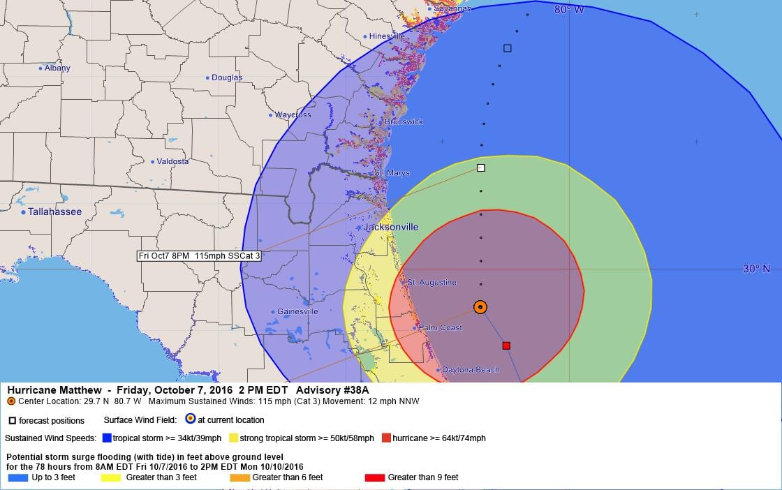
200 PM EDT FRI OCT 07 2016
…SEVERE HURRICANE MATTHEW LASHING THE NORTHEAST COAST OF
FLORIDA…
SUMMARY OF 200 PM EDT…1800 UTC…INFORMATION
———————————————-
LOCATION…29.7N 80.7W
ABOUT 40 MI…60 KM ESE OF ST. AUGUSTINE FLORIDA
ABOUT 60 MI…95 KM SE OF JACKSONVILLE BEACH FLORIDA
MAXIMUM SUSTAINED WINDS…115 MPH…185 KM/H
PRESENT MOVEMENT…NNW OR 345 DEGREES AT 12 MPH…19 KM/H
MINIMUM CENTRAL PRESSURE…947 MB…27.97 INCHES
WATCHES AND WARNINGS
——————–
CHANGES WITH THIS ADVISORY:
None.
SUMMARY OF WATCHES AND WARNINGS IN EFFECT:
A Hurricane Warning is in effect for…
* Cocoa Beach to Surf City
A Hurricane Watch is in effect for…
* North of Surf City to Cape Lookout
A Tropical Storm Warning is in effect for…
* Sebastian Inlet to Cocoa Beach
* North of Surf City to Duck
* Pamlico and Albemarle Sounds
For storm information specific to your area, including possible
inland watches and warnings, please monitor products issued by your
local National Weather Service forecast office.
DISCUSSION AND 48-HOUR OUTLOOK
——————————
At 200 PM EDT (1800 UTC), the eye of Hurricane Matthew was located
near latitude 29.7 North, longitude 80.7 West. Matthew is moving
toward the north-northwest near 13 mph (20 km/h), and this general
motion is expected to continue today. A turn toward the north is
expected tonight or Saturday. On the forecast track, the center of
Matthew will continue to move near or over the coast of northeast
Florida and Georgia through tonight, and near or over the coast of
South Carolina on Saturday.
Maximum sustained winds are near 115 mph (185 km/h) with higher
gusts. Matthew is a category 3 hurricane on the Saffir-Simpson
Hurricane Wind Scale. Although weakening is forecast during the
next 48 hours, Matthew is expected to remain a hurricane until it
begins to move away from the United States on Sunday.
Hurricane-force winds extend outward up to 60 miles (95 km) from
the center and tropical-storm-force winds extend outward up to 185
miles (295 km). A wind gust to 84 mph (135 km/h) was recently
reported at Ponte Vedra, and a coastal marine observing station at
St. Augustine recently measured a wind gust of 85 mph (137 km/h).
A tidal gauge at Fernandina Beach reported a storm surge inundation
of 3.11 feet above mean higher high water.
The latest minimum central pressure reported by an Air Force
Hurricane Hunter plane was 947 mb (27.97 inches).
HAZARDS AFFECTING LAND
———————-
WIND: Hurricane and tropical storm conditions are expected to
continue over the warning area in Florida today, and spread
northward within the warning area through Saturday.
Residents in high-rise buildings should be aware that the winds at
the top of a 30-story building will be, on average, about one
Saffir-Simpson category higher than the winds near the surface.
Tropical storm conditions are expected to first reach the tropical
storm warning area in North Carolina on Saturday morning.
STORM SURGE: The combination of a dangerous storm surge, the tide,
and large and destructive waves will cause normally dry areas near
the coast to be flooded by rising waters moving inland from the
shoreline. The water could reach the following heights above ground
if the peak surge occurs at the time of high tide…
Flagler Beach, Florida, to Edisto Beach, South Carolina, including
portions of the St. Johns River…6 to 9 ft
Cocoa Beach to Flagler Beach, Florida…4 to 6 ft
Edisto Beach, South Carolina to Cape Fear, North Carolina…
4 to 6 ft
Cape Fear to Salvo, North Carolina, including portions of the
Pamlico and Albemarle Sounds…2 to 4 ft
The deepest water will occur along the immediate coast in areas of
onshore winds. Surge-related flooding depends on the relative
timing of the surge and the tidal cycle, and can vary greatly over
short distances. Large waves generated by Matthew will cause water
rises to occur well in advance of and well away from the track of
the center. For information specific to your area, please see
products issued by your local National Weather Service forecast
office.
There is a danger of life-threatening inundation during the next 36
hours along the Florida northeast coast, the Georgia coast, the
South Carolina coast, and the North Carolina coast from Cocoa Beach,
Florida, to Cape Fear, North Carolina. There is the possibility of
life-threatening inundation during the next 48 hours from north of
Cape Fear to Salvo, North Carolina. For a depiction of areas at
risk, please see the Prototype National Weather Service Storm Surge
Watch/Warning Graphic. For information specific to your area, please
see products issued by your local National Weather Service forecast
office.
The Prototype Storm Surge Watch/Warning Graphic is a depiction of
areas that would qualify for inclusion under a storm surge watch or
warning currently under development by the National Weather Service
and planned for operational use in 2017. The Prototype Graphic is
available at hurricanes.gov.
RAINFALL: Matthew is expected to produce total rain accumulations of
8 to 12 inches over the Atlantic coast of the United States from
central Florida to eastern North Carolina…with possible isolated
maximum amounts of 15 inches. This rainfall may result in flooding
and flash flooding.
TORNADOES: An isolated tornado or two is possible along the South
Carolina, Georgia, and northeast Florida coasts today.
SURF: Swells generated by Matthew will continue to affect portions
of the Bahamas and the east coast of Florida during the next few
days, and will spread northward along the southeast U.S. coast
through the weekend. These swells will likely cause
life-threatening surf and rip current conditions. Please consult
products from your local weather office.
NEXT ADVISORY
————-
Next complete advisory at 500 PM EDT.
$$
Forecaster Avila
000
WTNT44 KNHC 071459
HURRICANE MATTHEW DISCUSSION NUMBER 38
NWS NATIONAL HURRICANE CENTER MIAMI FL AL142016
1100 AM EDT FRI OCT 07 2016
The satellite presentation has degraded during the past several
hours, and the eye is not very distinct. However, the SFMR and
flight-level wind data from an Air Force reconnaissance plane
indicate that the initial intensity is still 105 kt.
Matthew is expected to change little in intensity during the next 6
to 12 hours, but it should begin to weaken at a faster pace in
24 hours while the shear increases, and by the end of the forecast
period, Matthew is expected to become a tropical depression.
Fixes from a reconnaissance plane indicate that Matthew is moving
toward the north-northwest or 345 degrees at 10 kt. Matthew is
reaching the northwestern edge of the subtropical ridge and
encounter the mid-latitude westerlies. This flow pattern should
steer the hurricane northward and then northeastward during the
next 36 hours. After that time, the flow pattern is forecast
to change again and a weakening Matthew should then turn southward
and southwestward. The NHC forecast is a little bit to the
north from the previous one during the first 24 to 36 hour period
following the multi-model consensus. After 72 hours, models
continue to vary the flow pattern and the confidence in the track
forecast is low.
KEY MESSAGES:
1. We have been very fortunate that Matthew’s category 3 winds have
remained a short distance offshore of the Florida Coast thus far,
but this should not be a reason to let down our guard. Only a
small deviation to the left of the forecast track could bring these
winds onshore. The western eyewall of Matthew, which contains
hurricane-force winds, is expected to move over or very near the
coast of northeastern Florida and Georgia today.
2. Hurricane winds increase very rapidly with height, and occupants
of high-rise buildings in the Jacksonville area are at particular
risk of strong winds. Winds at the top of a 30-story building will
average one Saffir-Simpson category higher than the winds near the
surface.
3. The water hazards remain, even if the core of Matthew remains
offshore. These include the danger of life-threatening inundation
from storm surge, as well as inland flooding from heavy rains from
Florida to North Carolina.
4. The National Hurricane Center is issuing Potential Storm Surge
Flooding Maps, and Prototype Storm Surge Watch/Warning Graphics for
Matthew. It is important to remember that the Potential Storm Surge
Flooding Map does not represent a forecast of expected inundation,
but rather depicts a reasonable worst-case scenario — the amount of
inundation that has a 10 percent chance of being exceeded.
FORECAST POSITIONS AND MAX WINDS
INIT 07/1500Z 29.4N 80.4W 105 KT 120 MPH
12H 08/0000Z 30.8N 80.7W 100 KT 115 MPH
24H 08/1200Z 32.5N 79.9W 85 KT 100 MPH
36H 09/0000Z 33.5N 78.1W 75 KT 85 MPH
48H 09/1200Z 33.5N 76.0W 60 KT 70 MPH
72H 10/1200Z 32.0N 74.0W 50 KT 60 MPH
96H 11/1200Z 28.0N 75.0W 35 KT 40 MPH
120H 12/1200Z 27.0N 76.0W 30 KT 35 MPH
$$
Forecaster Avila
000
TCMAT4
HURRICANE MATTHEW FORECAST/ADVISORY NUMBER 38
NWS NATIONAL HURRICANE CENTER MIAMI FL AL142016
1500 UTC FRI OCT 07 2016
CHANGES IN WATCHES AND WARNINGS WITH THIS ADVISORY…
THE HURRICANE WARNING HAS BEEN EXTENDED NORTHEASTWARD TO SURF CITY
NORTH CAROLINA. THE HURRICANE WARNING FROM SEBASTIAN INLET TO COCOA
BEACH HAS BEEN CHANGED TO A TROPICAL STORM WARNING. THE TROPICAL
STORM WARNING SOUTH OF SEBASTIAN INLET HAS BEEN DISCONTINUED.
A TROPICAL STORM WARNING HAS BEEN ISSUED FROM NORTH OF SURF CITY TO
DUCK…NORTH CAROLINA INCLUDING THE PAMLICO AND ALBEMARLE SOUNDS.
A HURRICANE WATCH HAS BEEN ISSUED FROM SURF CITY TO CAPE LOOKOUT
NORTH CAROLINA.
THE TROPICAL STORM WARNING AND TROPICAL STORM WATCH ALONG THE
WEST COAST OF FLORIDA HAS BEEN DISCONTINUED.
SUMMARY OF WATCHES AND WARNINGS IN EFFECT…
A HURRICANE WARNING IS IN EFFECT FOR…
* COCOA BEACH TO SURF CITY
A HURRICANE WATCH IS IN EFFECT FOR…
* NORTH OF SURF CITY TO CAPE LOOKOUT
A TROPICAL STORM WARNING IS IN EFFECT FOR…
* SEBASTIAN INLET TO COCOA BEACH
* NORTH OF SURF CITY TO DUCK
* PAMLICO AND ALBEMARLE SOUNDS
INTERESTS ELSEWHERE IN THE FLORIDA PENINSULA AND IN THE CAROLINAS
SHOULD MONITOR THE PROGRESS OF MATTHEW.
HURRICANE CENTER LOCATED NEAR 29.4N 80.5W AT 07/1500Z
POSITION ACCURATE WITHIN 15 NM
PRESENT MOVEMENT TOWARD THE NORTH-NORTHWEST OR 345 DEGREES AT 10 KT
ESTIMATED MINIMUM CENTRAL PRESSURE 947 MB
EYE DIAMETER 30 NM
MAX SUSTAINED WINDS 105 KT WITH GUSTS TO 130 KT.
64 KT……. 50NE 40SE 40SW 40NW.
50 KT……. 80NE 70SE 60SW 60NW.
34 KT…….160NE 140SE 80SW 120NW.
12 FT SEAS..240NE 240SE 90SW 180NW.
WINDS AND SEAS VARY GREATLY IN EACH QUADRANT. RADII IN NAUTICAL
MILES ARE THE LARGEST RADII EXPECTED ANYWHERE IN THAT QUADRANT.
REPEAT…CENTER LOCATED NEAR 29.4N 80.5W AT 07/1500Z
AT 07/1200Z CENTER WAS LOCATED NEAR 28.9N 80.3W
FORECAST VALID 08/0000Z 30.8N 80.7W
MAX WIND 100 KT…GUSTS 120 KT.
64 KT… 50NE 40SE 40SW 40NW.
50 KT… 80NE 70SE 60SW 60NW.
34 KT…170NE 140SE 80SW 120NW.
FORECAST VALID 08/1200Z 32.5N 79.9W
MAX WIND 85 KT…GUSTS 105 KT.
64 KT… 50NE 40SE 30SW 40NW.
50 KT… 80NE 70SE 50SW 70NW.
34 KT…180NE 160SE 80SW 100NW.
FORECAST VALID 09/0000Z 33.5N 78.1W
MAX WIND 75 KT…GUSTS 90 KT.
64 KT… 40NE 40SE 20SW 20NW.
50 KT… 80NE 70SE 40SW 40NW.
34 KT…200NE 160SE 90SW 100NW.
FORECAST VALID 09/1200Z 33.5N 76.0W
MAX WIND 60 KT…GUSTS 75 KT.
50 KT… 60NE 60SE 40SW 30NW.
34 KT…150NE 150SE 120SW 90NW.
FORECAST VALID 10/1200Z 32.0N 74.0W
MAX WIND 50 KT…GUSTS 60 KT.
50 KT… 40NE 60SE 40SW 30NW.
34 KT…120NE 150SE 150SW 90NW.
EXTENDED OUTLOOK. NOTE…ERRORS FOR TRACK HAVE AVERAGED NEAR 150 NM
ON DAY 4 AND 200 NM ON DAY 5…AND FOR INTENSITY NEAR 15 KT EACH DAY
OUTLOOK VALID 11/1200Z 28.0N 75.0W
MAX WIND 35 KT…GUSTS 45 KT.
OUTLOOK VALID 12/1200Z 27.0N 76.0W
MAX WIND 30 KT…GUSTS 40 KT.
REQUEST FOR 3 HOURLY SHIP REPORTS WITHIN 300 MILES OF 29.4N 80.5W
NEXT ADVISORY AT 07/2100Z
$$
FORECASTER AVILA
000
PWSAT4
HURRICANE MATTHEW WIND SPEED PROBABILITIES NUMBER 38
NWS NATIONAL HURRICANE CENTER MIAMI FL AL142016
1500 UTC FRI OCT 07 2016
AT 1500Z THE CENTER OF HURRICANE MATTHEW WAS LOCATED NEAR LATITUDE
29.4 NORTH…LONGITUDE 80.5 WEST WITH MAXIMUM SUSTAINED WINDS NEAR
105 KTS…120 MPH…195 KM/H.
Z INDICATES COORDINATED UNIVERSAL TIME (GREENWICH)
ATLANTIC STANDARD TIME (AST)…SUBTRACT 4 HOURS FROM Z TIME
EASTERN DAYLIGHT TIME (EDT)…SUBTRACT 4 HOURS FROM Z TIME
CENTRAL DAYLIGHT TIME (CDT)…SUBTRACT 5 HOURS FROM Z TIME
WIND SPEED PROBABILITY TABLE FOR SPECIFIC LOCATIONS
CHANCES OF SUSTAINED (1-MINUTE AVERAGE) WIND SPEEDS OF AT LEAST
…34 KT (39 MPH… 63 KM/H)…
…50 KT (58 MPH… 93 KM/H)…
…64 KT (74 MPH…119 KM/H)…
FOR LOCATIONS AND TIME PERIODS DURING THE NEXT 5 DAYS
PROBABILITIES FOR LOCATIONS ARE GIVEN AS OP(CP) WHERE
OP IS THE PROBABILITY OF THE EVENT BEGINNING DURING
AN INDIVIDUAL TIME PERIOD (ONSET PROBABILITY)
(CP) IS THE PROBABILITY OF THE EVENT OCCURRING BETWEEN
12Z FRI AND THE FORECAST HOUR (CUMULATIVE PROBABILITY)
PROBABILITIES ARE GIVEN IN PERCENT
X INDICATES PROBABILITIES LESS THAN 1 PERCENT
PROBABILITIES FOR 34 KT AND 50 KT ARE SHOWN AT A GIVEN LOCATION WHEN
THE 5-DAY CUMULATIVE PROBABILITY IS AT LEAST 3 PERCENT.
PROBABILITIES FOR 64 KT ARE SHOWN WHEN THE 5-DAY CUMULATIVE
PROBABILITY IS AT LEAST 1 PERCENT.
– – – – WIND SPEED PROBABILITIES FOR SELECTED LOCATIONS – – – –
FROM FROM FROM FROM FROM FROM FROM
TIME 12Z FRI 00Z SAT 12Z SAT 00Z SUN 12Z SUN 12Z MON 12Z TUE
PERIODS TO TO TO TO TO TO TO
00Z SAT 12Z SAT 00Z SUN 12Z SUN 12Z MON 12Z TUE 12Z WED
FORECAST HOUR (12) (24) (36) (48) (72) (96) (120)
– – – – – – – – – – – – – – – – – – – – – – – – – – – – – – – – – –
LOCATION KT
OCEAN CITY MD 34 X X( X) 1( 1) 1( 2) 1( 3) 1( 4) X( 4)
PAX RIVER NAS 34 X X( X) 1( 1) 2( 3) 1( 4) X( 4) X( 4)
WALLOPS CDA 34 X X( X) 2( 2) 2( 4) 1( 5) X( 5) X( 5)
CHARLOTTESVIL 34 X X( X) 3( 3) 1( 4) X( 4) X( 4) X( 4)
RICHMOND VA 34 X 1( 1) 4( 5) 1( 6) 2( 8) X( 8) X( 8)
DANVILLE VA 34 X 4( 4) 4( 8) 2(10) 1(11) X(11) X(11)
NORFOLK NAS 34 X 1( 1) 5( 6) 4(10) 3(13) X(13) X(13)
NORFOLK VA 34 X 1( 1) 5( 6) 5(11) 3(14) X(14) X(14)
OCEANA NAS VA 34 X 1( 1) 6( 7) 5(12) 3(15) X(15) X(15)
ELIZABETH CTY 34 X 2( 2) 10(12) 7(19) 4(23) X(23) X(23)
GREENSBORO NC 34 1 5( 6) 3( 9) 2(11) 1(12) X(12) X(12)
RALEIGH NC 34 1 6( 7) 10(17) 2(19) 3(22) X(22) X(22)
ROCKY MT NC 34 X 6( 6) 12(18) 5(23) 3(26) X(26) X(26)
CAPE HATTERAS 34 X 4( 4) 17(21) 18(39) 8(47) X(47) X(47)
CAPE HATTERAS 50 X X( X) 2( 2) 5( 7) 3(10) X(10) X(10)
CAPE HATTERAS 64 X X( X) X( X) 1( 1) 1( 2) X( 2) X( 2)
FAYETTEVILLE 34 2 20(22) 24(46) 4(50) 1(51) X(51) X(51)
FAYETTEVILLE 50 X 1( 1) 4( 5) X( 5) X( 5) X( 5) X( 5)
CHARLOTTE NC 34 2 7( 9) 4(13) 1(14) 1(15) X(15) X(15)
CHERRY PT NC 34 1 9(10) 33(43) 14(57) 4(61) X(61) X(61)
CHERRY PT NC 50 X X( X) 9( 9) 7(16) 2(18) X(18) X(18)
CHERRY PT NC 64 X X( X) 2( 2) 1( 3) X( 3) X( 3) X( 3)
NEW RIVER NC 34 X 8( 8) 34(42) 18(60) 5(65) X(65) X(65)
NEW RIVER NC 50 X X( X) 10(10) 10(20) 3(23) X(23) X(23)
NEW RIVER NC 64 X X( X) 2( 2) 3( 5) 1( 6) X( 6) X( 6)
MOREHEAD CITY 34 1 10(11) 34(45) 18(63) 4(67) X(67) X(67)
MOREHEAD CITY 50 X X( X) 11(11) 10(21) 3(24) X(24) X(24)
MOREHEAD CITY 64 X X( X) 2( 2) 3( 5) X( 5) X( 5) X( 5)
SURF CITY NC 34 2 23(25) 38(63) 9(72) 3(75) X(75) X(75)
SURF CITY NC 50 X 1( 1) 21(22) 9(31) 1(32) X(32) X(32)
SURF CITY NC 64 X X( X) 6( 6) 3( 9) X( 9) X( 9) X( 9)
WILMINGTON NC 34 3 32(35) 35(70) 7(77) 1(78) X(78) X(78)
WILMINGTON NC 50 X 2( 2) 25(27) 6(33) 1(34) X(34) X(34)
WILMINGTON NC 64 X X( X) 8( 8) 1( 9) 1(10) X(10) X(10)
BALD HEAD ISL 34 4 44(48) 31(79) 4(83) 1(84) X(84) X(84)
BALD HEAD ISL 50 X 5( 5) 38(43) 5(48) X(48) X(48) X(48)
BALD HEAD ISL 64 X 1( 1) 18(19) 3(22) X(22) X(22) X(22)
FLORENCE SC 34 5 55(60) 14(74) 1(75) 1(76) X(76) X(76)
FLORENCE SC 50 X 7( 7) 7(14) 1(15) X(15) X(15) X(15)
COLUMBIA SC 34 5 43(48) 6(54) 1(55) X(55) X(55) X(55)
COLUMBIA SC 50 X 3( 3) 1( 4) X( 4) X( 4) X( 4) X( 4)
LITTLE RIVER 34 5 58(63) 21(84) 2(86) 1(87) X(87) X(87)
LITTLE RIVER 50 X 11(11) 34(45) 3(48) X(48) X(48) X(48)
LITTLE RIVER 64 X 2( 2) 15(17) 1(18) X(18) X(18) X(18)
MYRTLE BEACH 34 7 65(72) 16(88) 1(89) X(89) X(89) X(89)
MYRTLE BEACH 50 X 18(18) 34(52) 1(53) 1(54) X(54) X(54)
MYRTLE BEACH 64 X 4( 4) 19(23) 1(24) X(24) X(24) X(24)
GEORGETOWN SC 34 21 64(85) 7(92) 1(93) X(93) X(93) X(93)
GEORGETOWN SC 50 1 37(38) 23(61) 2(63) X(63) X(63) X(63)
GEORGETOWN SC 64 X 13(13) 21(34) X(34) X(34) X(34) X(34)
CHARLESTON SC 34 58 36(94) 2(96) X(96) X(96) X(96) X(96)
CHARLESTON SC 50 3 63(66) 8(74) X(74) X(74) X(74) X(74)
CHARLESTON SC 64 X 38(38) 7(45) X(45) X(45) X(45) X(45)
BEAUFORT MCAS 34 78 20(98) X(98) X(98) 1(99) X(99) X(99)
BEAUFORT MCAS 50 8 64(72) 2(74) X(74) X(74) X(74) X(74)
BEAUFORT MCAS 64 2 42(44) 1(45) X(45) X(45) X(45) X(45)
ATLANTA GA 34 2 3( 5) 2( 7) X( 7) X( 7) X( 7) X( 7)
AUGUSTA GA 34 8 29(37) 4(41) 1(42) X(42) X(42) X(42)
AUGUSTA GA 50 1 3( 4) X( 4) X( 4) X( 4) X( 4) X( 4)
SAVANNAH GA 34 86 12(98) X(98) X(98) X(98) X(98) X(98)
SAVANNAH GA 50 19 47(66) 2(68) X(68) X(68) X(68) X(68)
SAVANNAH GA 64 4 30(34) 1(35) X(35) X(35) X(35) X(35)
KINGS BAY GA 34 98 1(99) X(99) X(99) X(99) X(99) X(99)
KINGS BAY GA 50 71 4(75) X(75) X(75) X(75) X(75) X(75)
KINGS BAY GA 64 33 4(37) X(37) X(37) X(37) X(37) X(37)
WAYCROSS GA 34 66 5(71) 1(72) X(72) X(72) X(72) X(72)
WAYCROSS GA 50 6 3( 9) X( 9) X( 9) X( 9) X( 9) X( 9)
WAYCROSS GA 64 1 X( 1) X( 1) X( 1) X( 1) X( 1) X( 1)
MAYPORT NS FL 34 99 X(99) X(99) X(99) X(99) X(99) X(99)
MAYPORT NS FL 50 83 1(84) X(84) X(84) X(84) X(84) X(84)
MAYPORT NS FL 64 46 2(48) X(48) X(48) X(48) X(48) X(48)
JACKSONVILLE 34 97 X(97) X(97) X(97) X(97) X(97) X(97)
JACKSONVILLE 50 56 1(57) 1(58) X(58) X(58) X(58) X(58)
JACKSONVILLE 64 18 1(19) X(19) X(19) X(19) X(19) X(19)
GAINESVILLE FL 34 33 2(35) 2(37) X(37) X(37) X(37) X(37)
GAINESVILLE FL 50 2 1( 3) X( 3) X( 3) X( 3) X( 3) X( 3)
DAYTONA BEACH 34 99 X(99) X(99) X(99) X(99) X(99) X(99)
DAYTONA BEACH 50 99 X(99) X(99) X(99) X(99) X(99) X(99)
DAYTONA BEACH 64 32 X(32) X(32) X(32) X(32) X(32) X(32)
THE VILLAGES 34 22 2(24) 1(25) X(25) X(25) X(25) 1(26)
ORLANDO FL 34 99 X(99) X(99) X(99) X(99) X(99) X(99)
COCOA BEACH FL 34 99 X(99) X(99) X(99) X(99) X(99) X(99)
COCOA BEACH FL 50 99 X(99) X(99) X(99) X(99) X(99) X(99)
PATRICK AFB 34 99 X(99) X(99) X(99) X(99) X(99) X(99)
PATRICK AFB 50 99 X(99) X(99) X(99) X(99) X(99) X(99)
FT PIERCE FL 34 99 X(99) X(99) X(99) X(99) X(99) X(99)
W PALM BEACH 34 2 1( 3) X( 3) X( 3) X( 3) 2( 5) X( 5)
FT LAUDERDALE 34 2 X( 2) X( 2) X( 2) X( 2) 1( 3) 1( 4)
MIAMI FL 34 2 X( 2) X( 2) X( 2) X( 2) X( 2) 2( 4)
NAPLES FL 34 2 X( 2) X( 2) X( 2) X( 2) X( 2) 1( 3)
FT MYERS FL 34 2 X( 2) X( 2) X( 2) X( 2) 1( 3) X( 3)
VENICE FL 34 2 1( 3) X( 3) X( 3) X( 3) X( 3) 1( 4)
TAMPA FL 34 3 2( 5) 1( 6) X( 6) X( 6) X( 6) X( 6)
CEDAR KEY FL 34 3 3( 6) 1( 7) X( 7) X( 7) X( 7) X( 7)
TALLAHASSEE FL 34 3 3( 6) 1( 7) X( 7) X( 7) X( 7) X( 7)
ST MARKS FL 34 3 3( 6) X( 6) X( 6) X( 6) 1( 7) X( 7)
APALACHICOLA 34 2 2( 4) 1( 5) X( 5) X( 5) X( 5) X( 5)
GFMX 290N 850W 34 2 1( 3) X( 3) X( 3) X( 3) X( 3) X( 3)
PANAMA CITY FL 34 2 1( 3) X( 3) X( 3) X( 3) X( 3) X( 3)
COLUMBUS GA 34 2 3( 5) 1( 6) X( 6) X( 6) X( 6) X( 6)
GRAND BAHAMA 34 2 X( 2) X( 2) X( 2) 1( 3) 2( 5) X( 5)
NEW PROVIDENCE 34 X X( X) X( X) X( X) X( X) 3( 3) 3( 6)
ANDROS 34 X X( X) X( X) X( X) X( X) 1( 1) 3( 4)
GREAT EXUMA 34 X X( X) X( X) X( X) X( X) 2( 2) 1( 3)
SAN SALVADOR 34 X X( X) X( X) X( X) X( X) 3( 3) 1( 4)
$$
FORECASTER AVILA


Leave a Reply