000
WTPZ35 KNHC 230833
TCPEP5
BULLETIN
HURRICANE PATRICIA ADVISORY NUMBER 14
NWS NATIONAL HURRICANE CENTER MIAMI FL EP202015
400 AM CDT FRI OCT 23 2015
…PATRICIA…
…THE STRONGEST EASTERN NORTH PACIFIC HURRICANE ON RECORD…
…POTENTIALLY CATASTROPHIC LANDFALL IN SOUTHWESTERN MEXICO LATER
TODAY…
SUMMARY OF 400 AM CDT…0900 UTC…INFORMATION
———————————————-
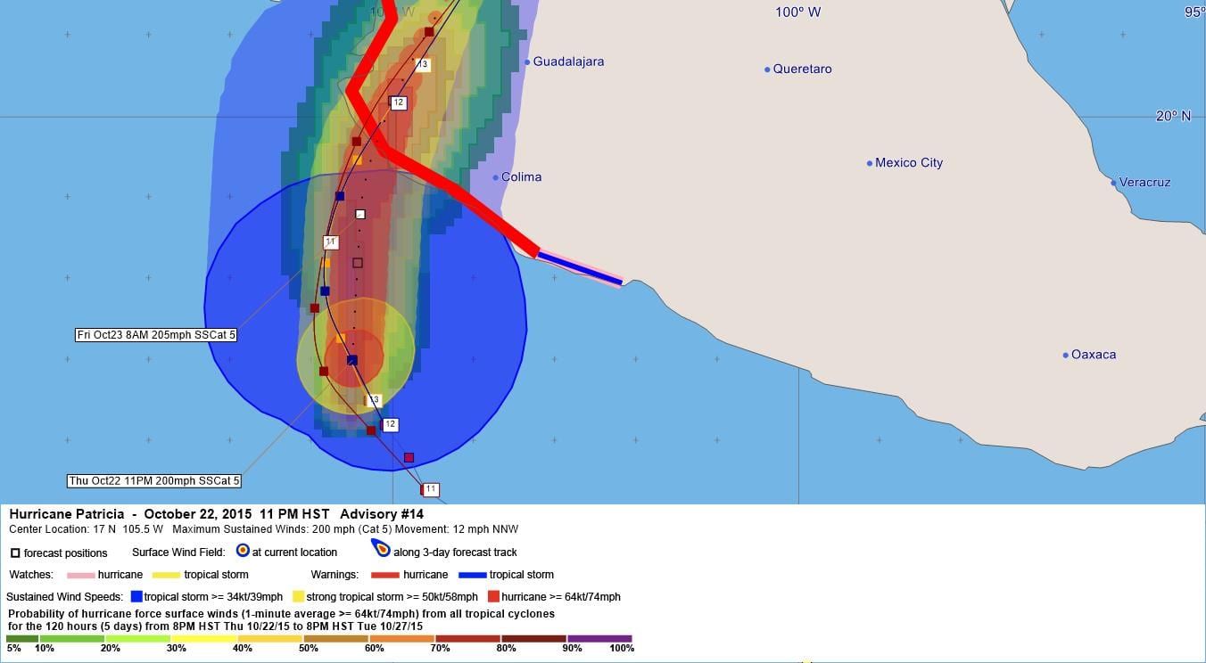
LOCATION…17.0N 105.5W
ABOUT 160 MI…255 KM SSW OF MANZANILLO MEXICO
ABOUT 235 MI…380 KM S OF CABO CORRIENTES MEXICO
MAXIMUM SUSTAINED WINDS…200 MPH…325 KM/H
PRESENT MOVEMENT…NNW OR 340 DEGREES AT 12 MPH…19 KM/H
MINIMUM CENTRAL PRESSURE…880 MB…25.99 INCHES
WATCHES AND WARNINGS
——————–
CHANGES WITH THIS ADVISORY:
None
SUMMARY OF WATCHES AND WARNINGS IN EFFECT:
A Hurricane Warning is in effect for…
* San Blas to Punta San Telmo
A Hurricane Watch is in effect for…
* East of Punta San Telmo to Lazaro Cardenas
A Tropical Storm Warning is in effect for…
* East of Punta San Telmo to Lazaro Cardenas
A Hurricane Warning means that hurricane conditions are expected
somewhere within the warning area, in this case within about 24
hours. Preparations to protect life and property should be rushed to
completion.
A Tropical Storm Warning means that tropical storm conditions are
expected somewhere within the warning area.
A Hurricane Watch means that hurricane conditions are possible
within the watch area.
For storm information specific to your area, please monitor
products issued by your national meteorological service.
DISCUSSION AND 48-HOUR OUTLOOK
——————————
At 400 AM CDT (0900 UTC), the eye of Hurricane Patricia was
located near latitude 17.0 North, longitude 105.5 West. Patricia
is moving toward the north-northwest near 10 mph (17 km/h). A turn
toward the north is expected later this morning, followed by a turn
toward the north-northeast this afternoon. On the forecast track,
the core of Patricia will make landfall in the hurricane warning
area this afternoon or evening.
Reports from an Air Force Hurricane Hunter aircraft indicate that
the maximum sustained winds have increased to near 200 mph (325
km/h) with higher gusts. Patricia is a category 5 hurricane on the
Saffir-Simpson Hurricane Wind Scale. Some fluctuations in intensity
are possible today, but Patricia is expected to remain an extremely
dangerous category 5 hurricane through landfall.
Hurricane force winds extend outward up to 30 miles (45 km) from the
center and tropical storm force winds extend outward up to 175 miles
(280 km).
The estimated minimum central pressure is 880 mb (25.99 inches).
HAZARDS AFFECTING LAND
———————-
WIND: Hurricane conditions are expected to first reach the
hurricane warning area this afternoon. Tropical storm conditions
are beginning to spread across portions of the warning area.
Preparations to protect life and property should be rushed to
completion. Hurricane conditions are possible in the hurricane
watch area later today.
RAINFALL: Patricia is expected to produce total rainfall
accumulations of 8 to 12 inches, with isolated maximum amounts of 20
inches, over the Mexican states of Nayarit, Jalisco, Colima,
MIchoacan and Guerrero through Saturday. These rains could produce
life-threatening flash floods and mud slides.
STORM SURGE: An extremely dangerous storm surge is expected to
produce significant coastal flooding near and to the right of where
the center makes landfall. Near the coast, the surge will be
accompanied by large and destructive waves.
SURF: Swells generated by Patricia are already affecting portions
of the southern coast of Mexico, and will spread northwestward
during the next day or so. These swells are likely to cause
life-threatening surf and rip current conditions. Please consult
products from your local weather office.
NEXT ADVISORY
————-
Next intermediate advisory at 700 AM CDT.
Next complete advisory at 1000 AM CDT.
$$
Forecaster Pasch
WTPZ45 KNHC 230834
TCDEP5
HURRICANE PATRICIA DISCUSSION NUMBER 14
NWS NATIONAL HURRICANE CENTER MIAMI FL EP202015
400 AM CDT FRI OCT 23 2015
Data from three center fixes by the Hurricane Hunters indicate
that the intensity, based on a blend of 700 mb-flight level and
SFMR-observed surface winds, is near 175 kt. This makes Patricia
the strongest hurricane on record in the National Hurricane Center’s
area of responsibility (AOR) which includes the Atlantic and the
eastern North Pacific basins. The minimum central pressure
estimated from the aircraft data, 880 mb, is the lowest ever for
our AOR. It seems incredible that even more strengthening could
occur before landfall later today, but recent microwave imagery
shows hints of a concentric eyewall developing. If the trend
toward an eyewall replacement continues, it would cause the
intensity to at least level off later today. The official forecast
shows only a little more strengthening before landfall. Given the
very mountainous terrain that Patricia should encounter after
landfall, the cyclone should weaken even faster over land than
predicted by the normal inland decay rate.
Recent center fixes show that the hurricane is gradually turning
toward the right, and the initial motion estimate is 340/10 kt. The
track forecast scenario remains about the same. Patricia should
continue to move around the western periphery of a mid-level
anticyclone today and turn north-northeastward ahead of a trough to
the northwest tonight and Saturday. The official track forecast is
somewhat slower than the latest model consensus and lies between
the GFS and ECMWF solutions.
The global models continue to depict the development of a cyclone
near the Texas coast over the weekend. Based on the predicted
upper-level winds, this system should be non-tropical in nature.
However this cyclone is expected to draw significant amounts of
moisture from Patricia’s remnants, and could result in locally
heavy rainfall over portions of the northwestern Gulf of Mexico
coastal area within the next few days. Refer to statements from
local National Weather Service forecast offices for details.
We would like to acknowledge deeply the Air Force Hurricane Hunters
for their observations establishing Patricia as a record-breaking
hurricane. Clearly, without their data, we would never have known
just how strong a tropical cyclone it was.
KEY MESSAGES:
1. Confidence is high that Patricia will make landfall in the
hurricane warning area along the coast of Mexico as an extremely
dangerous category 5 hurricane this afternoon or evening.
Preparations to protect life and property in the hurricane warning
area should have been completed, or rushed to completion, as
tropical storm conditions are beginning to affect the area.
Residents in low-lying areas near the coast in the hurricane warning
area should evacuate immediately, since the storm surge could be
catastrophic near and to the east of where the center makes
landfall.
2. In addition to the coastal impacts, very heavy rainfall is
likely to cause life-threatening flash floods and mud slides in the
Mexican states of Jalisco, Colima, Michoacan and Guerrero continuing
into Saturday.
FORECAST POSITIONS AND MAX WINDS
INIT 23/0900Z 17.0N 105.5W 175 KT 200 MPH
12H 23/1800Z 18.8N 105.4W 180 KT 205 MPH
24H 24/0600Z 21.7N 104.2W 60 KT 70 MPH…INLAND
36H 24/1800Z 24.5N 102.5W 20 KT 25 MPH…POST-TROP/REMNT LOW
48H 25/0600Z…DISSIPATED
$$
Forecaster Pasch


Leave a Reply