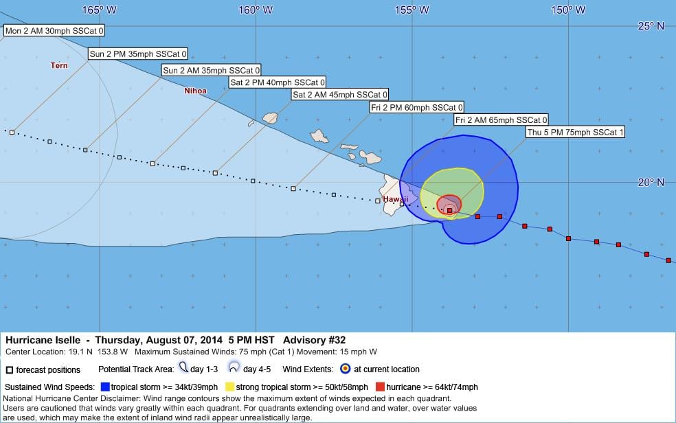
Tropical Cyclone Iselle Number 32 Public Advisory
WTPZ35 KNHC 072043
TCPEP5
BULLETIN
HURRICANE JULIO ADVISORY NUMBER 16
NWS NATIONAL HURRICANE CENTER MIAMI FL EP102014
200 PM PDT THU AUG 07 2014
…JULIO CONTINUING WESTWARD WITH LITTLE CHANGE IN STRENGTH…
SUMMARY OF 200 PM PDT…2100 UTC…INFORMATION
———————————————-
LOCATION…17.1N 137.7W
ABOUT 1155 MI…1855 KM E OF HILO HAWAII
MAXIMUM SUSTAINED WINDS…105 MPH…165 KM/H
PRESENT MOVEMENT…W OR 280 DEGREES AT 17 MPH…28 KM/H
MINIMUM CENTRAL PRESSURE…970 MB…28.65 INCHES
WATCHES AND WARNINGS
——————–
THERE ARE NO COASTAL WATCHES OR WARNINGS IN EFFECT.
INTERESTS IN THE HAWAIIAN ISLANDS SHOULD MONITOR THE PROGRESS OF
JULIO.
DISCUSSION AND 48-HOUR OUTLOOK
——————————
AT 200 PM PDT…2100 UTC…THE CENTER OF HURRICANE JULIO WAS LOCATED
NEAR LATITUDE 17.1 NORTH…LONGITUDE 137.7 WEST. JULIO IS MOVING
TOWARD THE WEST NEAR 17 MPH…28 KM/H…AND A GENERAL WESTWARD TO
WEST-NORTHWESTWARD MOTION IS EXPECTED DURING THE NEXT COUPLE OF
DAYS.
MAXIMUM SUSTAINED WINDS ARE NEAR 105 MPH…165 KM/H…WITH HIGHER
GUSTS. SOME WEAKENING IS FORECAST DURING THE NEXT 48 HOURS.
HURRICANE FORCE WINDS EXTEND OUTWARD UP TO 25 MILES…35 KM…FROM
THE CENTER…AND TROPICAL STORM FORCE WINDS EXTEND OUTWARD UP TO 90
MILES…150 KM.
THE ESTIMATED MINIMUM CENTRAL PRESSURE IS 970 MB…28.65 INCHES.
HAZARDS AFFECTING LAND
———————-
NONE.
NEXT ADVISORY
————-
NEXT COMPLETE ADVISORY…800 PM PDT.
$$
FORECASTER BEVEN
WWWW
000
WTPZ45 KNHC 072045
TCDEP5
HURRICANE JULIO DISCUSSION NUMBER 16
NWS NATIONAL HURRICANE CENTER MIAMI FL EP102014
200 PM PDT THU AUG 07 2014
Julio has changed little in organization during the past several
hours. The eye has become a little better defined in visible
imagery. However, the temperature and symmetry of the eyewall
cloud tops are about the same as they were 6 hours ago. Satellite
intensity estimates remain 90 kt from TAFB and 77 kt from SAB. In
addition, UW-CIMSS ADT/SATCON estimates are near 100 kt, and there
was a recent AMSU intensity estimate of 98 kt. The initial
intensity remains at a possibly conservative 90 kt. The cirrus
outflow is good to excellent over the western semicircle and poor
elsewhere.
The initial motion is now 280/15. Julio is expected to remain south
of the subtropical ridge for the next few days, which will keep it
on a westward to west-northwestward path. During the first 72
hours, the track guidance remains tightly clustered near the new
forecast track with the notable exception of the outlier GFDL model,
which still forecasts a track near the Hawaiian Islands. After 72
hours, the guidance has come into better agreement that the
subtropical ridge north of Hawaii will be stronger than earlier
forecast, and that Julio should turn more westward. However, there
is still some spread in the guidance, with the UKMET forecasting a
continued west-northwestward motion and the ECMWF forecasting a turn
toward the west-southwest. The multi-model consensus lies near the
previous forecast track, so the new track is just an update of the
previous advisory. The NOAA G-IV jet is currently flying a synoptic
surveillance mission for Julio.
The dynamical models forecast Julio to remain in a light vertical
wind shear environment during the next 2-3 days as the cyclone
passes over sea surface temperatures of 25C-26C. The intensity
guidance is in excellent agreement in showing a gradual weakening
during that time, and the intensity forecast follows this scenario.
The agreement breaks down after 72 hours as Julio starts moving over
warmer sea surface temperatures. During that period, the SHIPS/LGEM
models forecast Julio to be a moderate strength tropical storm,
while the GFDL/HWRF models forecast it to be a hurricane. In
addition, the large-scale models have some disagreement on how
much shear Julio will encounter. The later part of the forecast is
still a compromise between the two model camps, and the new forecast
lies close to the intensity consensus. It is possible that Julio
could get a little stronger than forecast during the next 6-12
hours.
FORECAST POSITIONS AND MAX WINDS
INIT 07/2100Z 17.1N 137.7W 90 KT 105 MPH
12H 08/0600Z 17.5N 140.0W 90 KT 105 MPH
24H 08/1800Z 18.1N 143.0W 85 KT 100 MPH
36H 09/0600Z 18.8N 146.0W 75 KT 85 MPH
48H 09/1800Z 19.8N 148.9W 65 KT 75 MPH
72H 10/1800Z 22.0N 154.0W 60 KT 70 MPH
96H 11/1800Z 24.0N 159.0W 55 KT 65 MPH
120H 12/1800Z 24.5N 163.0W 55 KT 65 MPH
$$
Forecaster Beven


Leave a Reply