Tropical Cyclone Julio Number 17 Public Advisory
WTPZ35 KNHC 080246
TCPEP5
BULLETIN
HURRICANE JULIO ADVISORY NUMBER 17
NWS NATIONAL HURRICANE CENTER MIAMI FL EP102014
800 PM PDT THU AUG 07 2014
…JULIO BECOMES THE FOURTH MAJOR HURRICANE OF THE EASTERN PACIFIC
SEASON…
…NEXT ADVISORY ISSUED BY THE CENTRAL PACIFIC HURRICANE CENTER…
SUMMARY OF 800 PM PDT…0300 UTC…INFORMATION
———————————————-
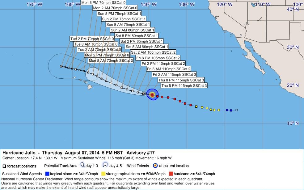
LOCATION…17.4N 139.1W
ABOUT 1060 MI…1705 KM E OF HILO HAWAII
ABOUT 1255 MI…2015 KM E OF HONOLULU HAWAII
MAXIMUM SUSTAINED WINDS…115 MPH…185 KM/H
PRESENT MOVEMENT…W OR 280 DEGREES AT 16 MPH…26 KM/H
MINIMUM CENTRAL PRESSURE…966 MB…28.53 INCHES
WATCHES AND WARNINGS
——————–
THERE ARE NO COASTAL WATCHES OR WARNINGS IN EFFECT.
INTERESTS IN THE HAWAIIAN ISLANDS SHOULD MONITOR THE PROGRESS OF
JULIO.
DISCUSSION AND 48-HOUR OUTLOOK
——————————
AT 800 PM PDT…0300 UTC…THE CENTER OF HURRICANE JULIO WAS LOCATED
NEAR LATITUDE 17.4 NORTH…LONGITUDE 139.1 WEST. JULIO IS MOVING
TOWARD THE WEST NEAR 16 MPH…26 KM/H…AND A GENERAL WESTWARD TO
WEST-NORTHWESTWARD MOTION IS EXPECTED DURING THE NEXT COUPLE OF
DAYS.
MAXIMUM SUSTAINED WINDS HAVE INCREASED TO NEAR 115 MPH…185 KM/H…
WITH HIGHER GUSTS. JULIO IS A CATEGORY THREE HURRICANE ON THE
SAFFIR-SIMPSON HURRICANE WIND SCALE. LITTLE CHANGE IN STRENGTH
IS FORECAST THROUGH FRIDAY…WITH SLOW WEAKENING EXPECTED TO
BEGIN ON FRIDAY EVENING.
HURRICANE FORCE WINDS EXTEND OUTWARD UP TO 35 MILES…55 KM…FROM
THE CENTER…AND TROPICAL STORM FORCE WINDS EXTEND OUTWARD UP TO 115
MILES…185 KM.
THE ESTIMATED MINIMUM CENTRAL PRESSURE IS 966 MB…28.53 INCHES.
HAZARDS AFFECTING LAND
———————-
NONE.
NEXT ADVISORY
————-
THIS IS THE LAST PUBLIC ADVISORY ISSUED BY THE NATIONAL HURRICANE
CENTER ON THIS SYSTEM. FUTURE ADVISORIES WILL BE ISSUED BY THE
CENTRAL PACIFIC HURRICANE CENTER UNDER AWIPS HEADER HFOTCPCP5 AND
WMO HEADER WTPA35 PHFO…BEGINNING AT 1100 PM HST.
$$
FORECASTER BLAKE
WWWW
WTPZ45 KNHC 080247
TCDEP5
HURRICANE JULIO DISCUSSION NUMBER 17
NWS NATIONAL HURRICANE CENTER MIAMI FL EP102014
800 PM PDT THU AUG 07 2014
Despite a marginal environment, Julio has become better organized
over the past several hours with warming temperatures in the eye
and strong convection in the eyewall. Subjective and objective
Dvorak estimates from all agencies suggest that the intensity has
increased to at least 100 kt, so the initial wind speed is raised to
that value.
With few outer bands and a symmetric structure around the eye,
Julio now appears to have become an annular hurricane, much like
Iselle in the same general area a few days ago. While guidance
is generally showing a steady or quick weakening, these hurricanes
are known to be more resilent to marginal environments than most.
Since little change is expected to the SSTs or shear for the next
day or so, it makes sense to go above the model guidance at that
time with the current annular structure, and the NHC prediction is
raised from the previous one. An increase in westerly shear after
that time could cause Julio to transition into a more conventional
cyclone structure, so the intensity forecast is blended with the
previous interpolated forecast and the model consensus. At long
range, although the SSTs are forecast to rise, there could also be
an increase in shear. With the large uncertainty, little change is
made to the extended-range intensity prediction.
Julio is moving at about 280/14. There has been no change to the
forecast synoptic pattern with the hurricane expected to remain
south of the subtropical ridge for the next few days, with a
westward turn at long range due to the ridge strengthening. Track
guidance is in better agreement than the last cycle, with even
the GFDL model, formerly an outlier solution near Hawaii, shifting
northward away from the islands. The new NHC prediction is
adjusted a bit to the north at longer range, close to the model
consensus, although most of the better performing individual models
are still farther north. It should be noted that data from a NOAA
G-IV jet synoptic surveillance mission for Julio should be included
in the 0000 UTC model runs.
Julio is expected to move into the Central Pacific Hurricane
Center’s area of responsibility by 0900 UTC and will issue the next
advisory on this system.
FORECAST POSITIONS AND MAX WINDS
INIT 08/0300Z 17.4N 139.1W 100 KT 115 MPH
12H 08/1200Z 17.8N 141.4W 100 KT 115 MPH
24H 09/0000Z 18.5N 144.3W 95 KT 110 MPH
36H 09/1200Z 19.4N 147.1W 85 KT 100 MPH
48H 10/0000Z 20.6N 149.9W 75 KT 85 MPH
72H 11/0000Z 22.9N 154.7W 65 KT 75 MPH
96H 12/0000Z 24.2N 159.2W 60 KT 70 MPH
120H 13/0000Z 25.0N 163.0W 60 KT 70 MPH
$$
Forecaster Blake
WWWW


Leave a Reply