000
WTPZ33 KNHC 212037
TCPEP3
BULLETIN
TROPICAL DEPRESSION EIGHT-E ADVISORY NUMBER 1
NWS NATIONAL HURRICANE CENTER MIAMI FL EP082016
300 PM MDT THU JUL 21 2016
…NEW TROPICAL DEPRESSION FORMS WELL SOUTHWEST OF MEXICO…
SUMMARY OF 300 PM MDT…2100 UTC…INFORMATION
———————————————-
LOCATION…10.8N 114.0W
ABOUT 880 MI…1415 KM SSW OF THE SOUTHERN TIP OF BAJA CALIFORNIA
MAXIMUM SUSTAINED WINDS…35 MPH…55 KM/H
PRESENT MOVEMENT…WNW OR 290 DEGREES AT 12 MPH…19 KM/H
MINIMUM CENTRAL PRESSURE…1006 MB…29.71 INCHES
WATCHES AND WARNINGS
——————–
There are no coastal watches or warnings in effect.
DISCUSSION AND 48-HOUR OUTLOOK
——————————
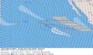
At 300 PM MDT (2100 UTC), the center of Tropical Depression Eight-E
was located near latitude 10.8 North, longitude 114.0 West. The
depression is moving toward the west-northwest near 12 mph (19 km/h)
and this general motion is expected to continue for the next couple
of days.
Maximum sustained winds are near 35 mph (55 km/h) with higher gusts.
Some strengthening is forecast during the next 48 hours, and the
depression is expected to become a tropical storm by tonight or
early Friday.
The estimated minimum central pressure is 1006 mb (29.71 inches).
HAZARDS AFFECTING LAND
———————-
None
NEXT ADVISORY
————-
Next complete advisory at 900 PM MDT.
$$
Forecaster Brennan
000
WTPZ43 KNHC 212037
TCDEP3
TROPICAL DEPRESSION EIGHT-E DISCUSSION NUMBER 1
NWS NATIONAL HURRICANE CENTER MIAMI FL EP082016
300 PM MDT THU JUL 21 2016
An ASCAT-B pass at 1742Z showed that the area of low pressure
located well southwest of Mexico now has a well-defined center, and
the geostationary imagery shows a curved convective band wrapping
nearly halfway around the system. Given this, the low is now
classified as a tropical cyclone. The initial intensity is set to
30 kt based on the ASCAT data, which is also in agreement with the
latest Dvorak estimate from SAB. The depression will be moving over
SSTs of 28C or higher for the next couple of days, but will also be
in a moderate easterly to northeasterly shear environment during
that time. Given these conditions, gradual intensification is
forecast in the short term. The cyclone is forecast to peak in
about 72 hours before it moves over cooler waters and into a more
stable environment, which should result in slow weakening. The NHC
intensity prediction is close to the intensity consensus through the
forecast period.
The initial motion estimate is a somewhat uncertain 290/10 given the
recent formation of the system. The dominant steering mechanism for
the first 2-3 days of the forecast period will be a large
subtropical ridge that will migrate westward from central North
America over the eastern Pacific. This should keep the cyclone
moving generally west-northwestward for the first 48 hours or so.
After that time, there is an increase in the spread of the guidance.
The ECMWF and HWRF show the cyclone turning more poleward into a
weakness in the ridge caused by an upper-level low, with the ECMWF
showing some northward motion possibly due to the influence of
Tropical Storm Fred to the the northeast. The GFS, GEFS mean, and
COAMPS-TC show a more westward track with the cyclone staying south
of the ridge. For now the NHC track forecast is down the middle of
the guidance envelope and is very close to the multi-model
consensus. Given the large spread in the guidance, the track
forecast uncertainty is higher than usual late in the forecast
period.
FORECAST POSITIONS AND MAX WINDS
INIT 21/2100Z 10.8N 114.0W 30 KT 35 MPH
12H 22/0600Z 11.4N 115.5W 35 KT 40 MPH
24H 22/1800Z 12.3N 117.6W 45 KT 50 MPH
36H 23/0600Z 13.0N 119.9W 50 KT 60 MPH
48H 23/1800Z 13.6N 122.0W 60 KT 70 MPH
72H 24/1800Z 15.0N 125.0W 65 KT 75 MPH
96H 25/1800Z 17.0N 128.0W 55 KT 65 MPH
120H 26/1800Z 18.0N 130.0W 50 KT 60 MPH
$$
Forecaster Brennan


Leave a Reply