WTPA33 PHFO 242048
TCPCP3
BULLETIN
TROPICAL STORM DARBY ADVISORY NUMBER 53
NWS CENTRAL PACIFIC HURRICANE CENTER HONOLULU HI EP052016
1100 AM HST SUN JUL 24 2016
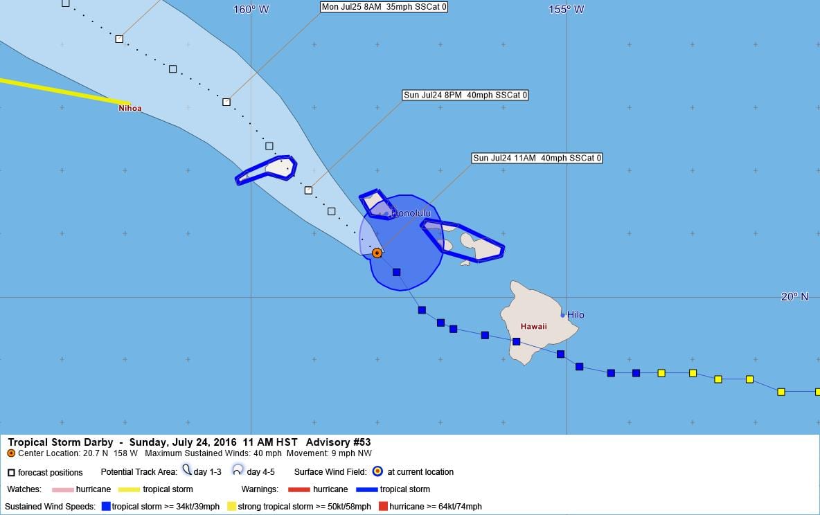
…DARBY STILL A TROPICAL STORM SOUTH OF OAHU…
SUMMARY OF 1100 AM HST…2100 UTC…INFORMATION
———————————————–
LOCATION…20.7N 158.0W
ABOUT 40 MI…70 KM S OF HONOLULU HAWAII
ABOUT 125 MI…205 KM SE OF LIHUE HAWAII
MAXIMUM SUSTAINED WINDS…40 MPH…65 KM/H
PRESENT MOVEMENT…NW OR 315 DEGREES AT 9 MPH…15 KM/H
MINIMUM CENTRAL PRESSURE…1010 MB…29.83 INCHES
WATCHES AND WARNINGS
——————–
CHANGES WITH THIS ADVISORY:
None.
SUMMARY OF WATCHES AND WARNINGS IN EFFECT:
A Tropical Storm Warning is in effect for…
* All islands in the state of Hawaii, except the Big Island.
A Tropical Storm Watch is in effect for…
* Papahanaumokuakea Marine National Monument…from Nihoa Island to
French Frigate Shoals.
A Tropical Storm Warning means that tropical storm conditions are
imminent or already occurring. In this case, Tropical Storm
conditions are expected over Maui County and Oahu today through
tonight, and over Kauai late tonight and Monday.
A Tropical Storm Watch means that Tropical Storm conditions are
possible within the watch area…generally within 36 to 48 hours.
For storm information specific to your area, please monitor
products issued by the National Weather Service office in
Honolulu Hawaii.
DISCUSSION AND 48-HOUR OUTLOOK
——————————
At 1100 AM HST (2100 UTC), the center of Tropical Storm Darby was
located near latitude 20.7 North, longitude 158.0 West. Darby is
moving toward the northwest near 9 mph (15 km/h) and this motion is
expected to continue over the next 48 hours.
Maximum sustained winds are near 40 mph (65 km/h) with higher gusts
based on aircraft reonnaissance data. Some weakening is expected
with Darby forecast to become a tropical depression tonight or
Monday.
Tropical-storm-force winds extend outward up to 80 miles (130 km)
from the center.
The estimated minimum central pressure is 1010 mb (29.83 inches).
HAZARDS AFFECTING LAND
———————-
WIND: Tropical Storm force winds are expected over parts of Maui
County and Oahu through tonight, and over Kauai late tonight and
Monday.
SURF: Swells generated by Darby are impacting the Hawaiian Islands,
and will continue through tonight before diminishing on Monday.
RAINFALL: Storm total rainfall of 6 to 10 inches, with isolated
amounts of up to 15 inches. These rains could produce
life-threatening flash floods and landslides.
NEXT ADVISORY
————-
Next intermediate advisory at 200 PM HST.
Next complete advisory at 500 PM HST.
$$
Forecaster Kodama
WTPA43 PHFO 242054
TCDCP3
TROPICAL STORM DARBY DISCUSSION NUMBER 53
NWS CENTRAL PACIFIC HURRICANE CENTER HONOLULU HI EP052016
1100 AM HST SUN JUL 24 2016
Due to vertical shear affecting Darby, most of the deep convection
is mainly confined to the southeast quadrant with some isolated
thunderstorms to the northeast of the main Hawaiian Islands. The
morning mission from the 53rd Weather Reconnaissance Squadron’s
WC-130J found the center of Darby to be a bit north of the previous
forecast track with maximum winds of 36 kt to the east of the
center. Based on the aircraft recon data, the initial intensity of
Darby has been maintained at 35 kt, but perhaps barely so at this
point. Additional passes through the system are ongoing and will
hopefully provide a better idea of the consistency of the current
trends.
Darby is becoming a shallow system and is moving at 315/8 kt to the
southwest of a lower and middle-level pressure ridge. The
trusted dynamical objective aids were tightly clustered showing a
northwestward track with the center of Darby passing near or over
Oahu and Kauai later today or tonight, then continuing
northwestward through 72 hours. The forecast track has been nudged
north a bit due to the shift in the initial position, but keeps
Darby moving northwestward through 72 hours.
Sea surface temperatures should be decreasing along Darby’s
forecast track and vertical shear is expected to remain relatively
strong through the next couple of days. This should result in steady
weakening of the tropical cyclone. Thus, the forecast call for Darby
to remain a tropical storm through today then become a tropical
depression tonight or Monday, followed by post-tropical remnant low
status in about 72 hours. This is close to the previous forecast but
is a bit lower than intensity consensus which holds on to tropical
storm intensity a bit longer.
FORECAST POSITIONS AND MAX WINDS
INIT 24/2100Z 20.7N 158.0W 35 KT 40 MPH
12H 25/0600Z 21.7N 159.1W 35 KT 40 MPH
24H 25/1800Z 23.1N 160.4W 30 KT 35 MPH
36H 26/0600Z 24.1N 162.1W 30 KT 35 MPH
48H 26/1800Z 25.3N 163.8W 30 KT 35 MPH
72H 27/1800Z 28.6N 166.5W 25 KT 30 MPH…POST-TROP/REMNT LOW
96H 28/1800Z 33.0N 166.5W 25 KT 30 MPH…POST-TROP/REMNT LOW
120H 29/1800Z…DISSIPATED
$$
Forecaster Kodama


Leave a Reply