BULLETIN
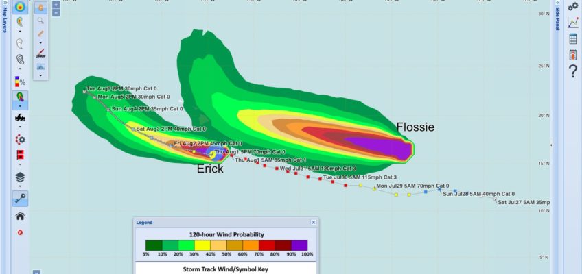
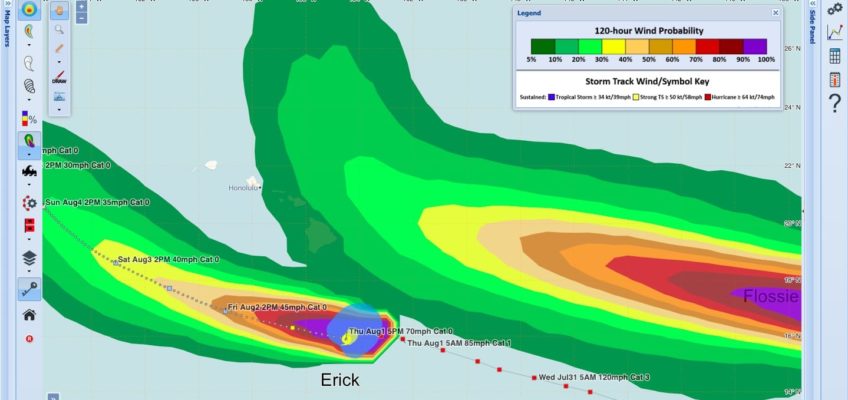
Tropical Storm Erick Advisory Number 23
NWS Central Pacific Hurricane Center Honolulu HI EP062019
500 PM HST Thu Aug 01 2019
…ERICK RAPIDLY WEAKENING WELL SOUTH OF THE BIG ISLAND…
SUMMARY OF 500 PM HST…0300 UTC…INFORMATION
———————————————-
LOCATION…15.9N 154.5W
ABOUT 265 MI…425 KM S OF HILO HAWAII
ABOUT 435 MI…700 KM SSE OF HONOLULU HAWAII
MAXIMUM SUSTAINED WINDS…70 MPH…110 KM/H
PRESENT MOVEMENT…WNW OR 285 DEGREES AT 13 MPH…20 KM/H
MINIMUM CENTRAL PRESSURE…993 MB…29.33 INCHES
WATCHES AND WARNINGS
——————–
There are no coastal watches or warnings in effect.
DISCUSSION AND OUTLOOK
———————-
At 500 PM HST (0300 UTC), the center of Tropical Storm Erick was
located near latitude 15.9 North, longitude 154.5 West. Erick is
moving toward the west-northwest near 13 mph, and this motion is
expected to continue over the next couple of days. On the forecast
track, the center of Erick will pass within about 200 miles
south of the Big Island of Hawaii tonight.
Maximum sustained winds are near 70 mph (110 km/h) with higher
gusts. Significant weakening is forecast during the next couple of
days, and Erick is expected to weaken to a tropical depression by
Sunday.
Tropical-storm-force winds extend outward up to 105 miles (165 km)
from the center.
The estimated minimum central pressure is 993 mb (29.33 inches).
HAZARDS AFFECTING LAND
———————-
SURF: Swells generated by Erick will build across the Hawaiian
Islands into this evening then decline late tonight and Friday,
producing dangerous surf conditions, mainly along east and southeast
facing shores.
RAINFALL: Moisture associated with Erick will spread over portions
of the Hawaiian Islands through Saturday, bringing the potential for
localized heavy rainfall. Total rainfall amounts of 4 to 8 inches
are possible, with localized higher amounts.
Please consult products from the National Weather Service in
Honolulu for more information.
NEXT ADVISORY
————-
Next complete advisory at 1100 PM HST.
$$
FORECASTER WROE
NNNN


Leave a Reply