Experimental Research & Development Graphical Rendering HVX-2.1.0
WATCHES AND WARNINGS
--------------------
There are no coastal watches or warnings in effect.


DISCUSSION AND OUTLOOK
----------------------
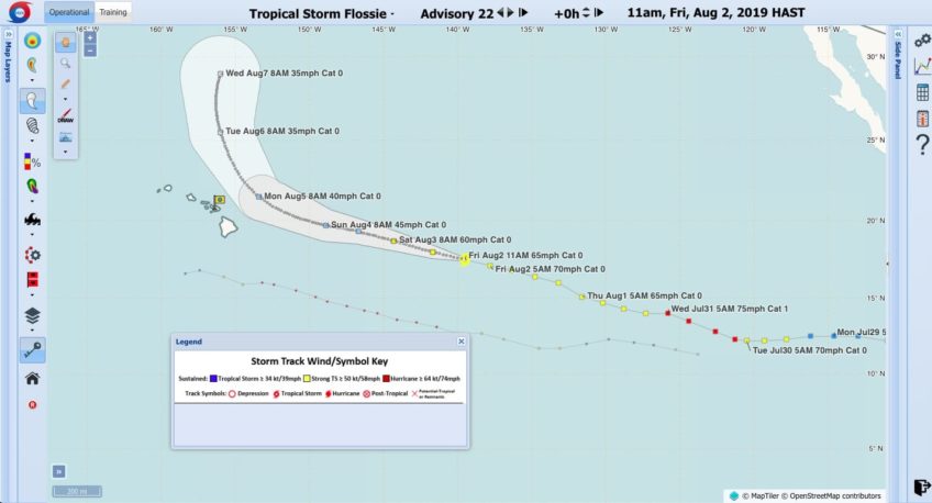
At 1100 AM HST (2100 UTC), the center of Tropical Storm Flossie was
located near latitude 17.5 North, longitude 139.5 West. Flossie is
moving toward the west-northwest near 17 mph (28 km/h), and this
general motion with a slight decrease in forward speed is expected
through early next week.  On the forecast track, Flossie is forecast
to cross into the central Pacific basin during the next few hours.

Maximum sustained winds are now near 65 mph (100 km/h) with higher
gusts.  Gradual weakening is anticipated over the weekend and
will likely continue through early next week.

Tropical-storm-force winds extend outward up to 140 miles (220 km)
from the center.

The estimated minimum central pressure is 994 mb (29.36 inches).


HAZARDS AFFECTING LAND
----------------------
None.


NEXT ADVISORY
-------------
This is the last public advisory issued by the National Hurricane
Center on this system.  Future information on this system can be
found in Public Advisories issued by the Central Pacific Hurricane
Center beginning at 500 PM HST, under AWIPS header HFOTCPCP2 and
WMO header WTPA32 PHFO.  Products will continue to be available on
the web at hurricanes.gov

$$
FORECASTER BEVEN

NNNN





Leave a Reply