092
WTPA35 PHFO 111803
TCPCP5
BULLETIN
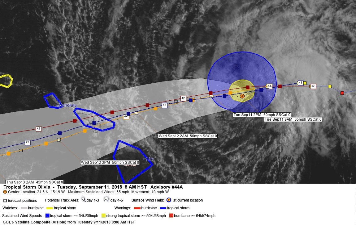
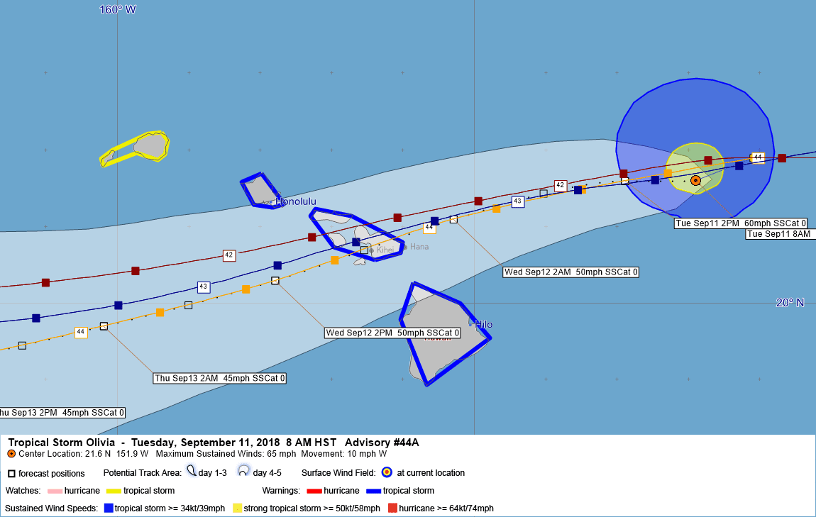
Tropical Storm Olivia Intermediate Advisory Number 44A
NWS Central Pacific Hurricane Center Honolulu HI EP172018
800 AM HST Tue Sep 11 2018
…OUTERMOST SHOWER BANDS ASSOCIATED WITH TROPICAL STORM OLIVIA
GRADUALLY SPREADING ACROSS THE MAIN HAWAIIAN ISLANDS…
SUMMARY OF 800 AM HST…1800 UTC…INFORMATION
———————————————-
LOCATION…21.6N 151.9W
ABOUT 240 MI…385 KM ENE OF KAHULUI HAWAII
ABOUT 380 MI…610 KM E OF HONOLULU HAWAII
MAXIMUM SUSTAINED WINDS…65 MPH…105 KM/H
PRESENT MOVEMENT…W OR 270 DEGREES AT 10 MPH…17 KM/H
MINIMUM CENTRAL PRESSURE…999 MB…29.50 INCHES
WATCHES AND WARNINGS
——————–
CHANGES WITH THIS ADVISORY:
None.
SUMMARY OF WATCHES AND WARNINGS IN EFFECT:
A Tropical Storm Warning is in effect for…
* Oahu
* Maui County…including the islands of Maui, Molokai, Lanai, and
Kahoolawe
* Hawaii County
A Tropical Storm Watch is in effect for…
* Kauai County…including the islands of Kauai and Niihau.
A Tropical Storm Warning means that tropical storm conditions are
expected somewhere in the warning area within 36 hours.
A Tropical Storm Watch means that tropical storm conditions are
possible in the watch area within 48 hours.
For storm information specific to your area, please monitor
products issued by the National Weather Service office in
Honolulu Hawaii.
DISCUSSION AND OUTLOOK
———————-
At 800 AM HST (1800 UTC), the center of Tropical Storm Olivia was
located near latitude 21.6 North, longitude 151.9 West. Olivia is
moving toward the west near 10 mph (17 km/h). A turn to the
west-southwest is expected later today, with a slight increase in
forward speed. This general motion will then continue for the next
couple of days. On the forecast track, the center of Olivia will be
moving the main Hawaiian Islands late tonight into Wednesday.
Maximum sustained winds are near 65 mph (105 km/h) with higher
gusts. Gradual weakening is forecast during the next 48 hours, but
Olivia is expected to remain a tropical storm as it moves over the
islands.
Tropical-storm-force winds extend outward up to 90 miles (150 km)
from the center.
The estimated minimum central pressure is 999 mb (29.50 inches).
HAZARDS AFFECTING LAND
———————-
WIND: Tropical storm conditions are expected over Maui County and
the Big Island starting tonight. Tropical storm conditions are
expected over Oahu starting Wednesday morning. Tropical storm
conditions are possible over Kauai County starting Wednesday
afternoon or evening.
RAINFALL: Showers will continue to gradually increase over portions
of the main Hawaiian Islands today ahead of Tropical Storm Olivia.
Olivia is expected to produce total rainfall accumulations of 5 to
10 inches in some areas, with isolated maximum amounts of 15 inches
possible, especially in higher terrain. This rainfall may produce
life-threatening flash flooding.
SURF: Large swells generated by Olivia will impact the main Hawaiian
Islands over the next couple of days. This will result in
dangerously high and potentially damaging surf, mainly along
exposed east facing shores.
NEXT ADVISORY
————-
Next complete advisory at 1100 AM HST.
$$
Forecaster R Ballard
810
WTPA45 PHFO 111453
TCDCP5
Tropical Storm Olivia Discussion Number 44
NWS Central Pacific Hurricane Center Honolulu HI EP172018
500 AM HST Tue Sep 11 2018
Hurricane Hunters from the 53rd Weather Reconnaissance Squadron
spent most of the night flying through Olivia, sampling the core as
well the periphery. Maximum flight level winds of 78 kt were
observed in the northwest quadrant fairly early in the evening, but
subsequent observations indicated that Olivia is well below
hurricane intensity. The surface pressure was gradually rising, and
the system exhibited tilt with height, with the low-level center on
the south side of the cold cloud tops seen in satellite.
Additionally, the observed wind field was rather asymmetric, with
winds fairly weak in the southern semicircle. The initial intensity
for this advisory is deemed to be 55 kt, and given current
satellite trends, this may be slightly generous.
The aircraft center fixes add confidence to the initial motion
estimate of 270/9 kt. Olivia is being steered by a mid-level ridge
centered to the distant northeast, but a mid-level ridge building
to the northwest of Olivia will induce a motion toward the west-
southwest later today. Once this occurs, this motion is expected to
persist as Olivia crosses the Hawaiian Islands. The updated track
forecast is very close to the previous, especially over the first
48 hours. In 48 to 72 hours, a low aloft is expected to develop
north of Olivia, and this development is expected to impart a
motion toward the west-northwest on days 4 and 5. The official
forecast is now near the center of the guidance envelope, and is
close to the multi-model consensus TVCE and GFEX. The along-track
differences between the GFS and ECMWF were reduced with the arrival
of the 06Z GFS, adding confidence to the short term forecast track,
which indicates a slightly faster speed of motion than the previous
forecast.
Moderate shear is expected to continue over the next 48 hours while
SSTs increase to 28C. The shear is expected to induce slow
weakening as indicated by nearly all intensity guidance, with
interaction with island terrain potentially contributing to
weakening as well. After Olivia exits the Hawaiian Islands to the
west in 48 to 72 hours, a cold core low aloft is expected to develop
north of Olivia. By 96 hours the cold core low and Olivia become
vertically stacked, potentially resulting in Olivia becoming
post-tropical. The official intensity forecast indicates this will
occur by day 5, and closely follows IVCN through the bulk of the
forecast.
Key Messages:
1. Although Olivia is expected to move over the islands as a
tropical storm, it could still bring significantly worse impacts
than recent Hurricane Lane. Those impacts could include intense
flooding rainfall, damaging winds, and large and dangerous surf.
2. It is important to not focus on the exact forecast track
and intensity when planning for Olivia. Regardless of the track
that Olivia takes as it approaches the islands, significant impacts
can be expected away from the center. In particular, the
mountainous terrain of Hawaii can produce localized areas of
strongly enhanced wind gusts and rainfall.
FORECAST POSITIONS AND MAX WINDS
INIT 11/1500Z 21.9N 151.1W 55 KT 65 MPH
12H 12/0000Z 21.6N 152.9W 50 KT 60 MPH
24H 12/1200Z 21.1N 155.3W 45 KT 50 MPH
36H 13/0000Z 20.3N 157.8W 45 KT 50 MPH
48H 13/1200Z 19.7N 160.2W 40 KT 45 MPH
72H 14/1200Z 19.3N 164.7W 40 KT 45 MPH
96H 15/1200Z 20.5N 169.5W 35 KT 40 MPH
120H 16/1200Z 21.6N 174.0W 30 KT 35 MPH…POST-TROP/REMNT LOW
$$
Forecaster Birchard


Leave a Reply