770
WTPA35 PHFO 121759
TCPCP5
BULLETIN
Tropical Storm Olivia Intermediate Advisory Number 48A
NWS Central Pacific Hurricane Center Honolulu HI EP172018
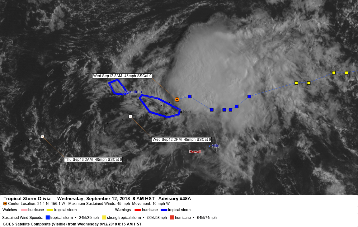
800 AM HST Wed Sep 12 2018
…CENTER OF OLIVIA JUST OFF THE NORTHERN COAST OF MAUI AND MOVING
TOWARD THE WEST…
SUMMARY OF 800 AM HST…1800 UTC…INFORMATION
———————————————-
LOCATION…21.1N 156.1W
ABOUT 25 MI…40 KM ENE OF KAHULUI HAWAII
ABOUT 115 MI…185 KM E OF HONOLULU HAWAII
MAXIMUM SUSTAINED WINDS…45 MPH…75 KM/H
PRESENT MOVEMENT…W OR 270 DEGREES AT 10 MPH…17 KM/H
MINIMUM CENTRAL PRESSURE…1005 MB…29.68 INCHES
WATCHES AND WARNINGS
——————–
CHANGES WITH THIS ADVISORY:
None.
SUMMARY OF WATCHES AND WARNINGS IN EFFECT:
A Tropical Storm Warning is in effect for…
* Oahu
* Maui County…including the islands of Maui, Molokai, Lanai, and
Kahoolawe
Interests in the Northwest Hawaiian Islands should monitor the
progress of Olivia.
A Tropical Storm Warning means that tropical storm conditions are
expected somewhere in the warning area.
For storm information specific to your area, please monitor
products issued by the National Weather Service office in
Honolulu Hawaii.
DISCUSSION AND OUTLOOK
———————-
At 800 AM HST (1800 UTC), the center of Tropical Storm Olivia was
located near latitude 21.1 North, longitude 156.1 West. Olivia is
moving toward the west near 10 mph (17 km/h). A turn toward the
west-southwest is expected today, with an increase in forward
speed. This general motion is then expected to continue the next
couple of days.
Maximum sustained winds are near 45 mph (75 km/h) with higher
gusts. Some weakening is forecast during the next 48 hours.
Tropical-storm-force winds extend outward up to 90 miles (150 km)
from the center.
The estimated minimum central pressure is 1005 mb (29.68 inches).
HAZARDS AFFECTING LAND
———————-
WIND: Tropical storm conditions are expected in Maui County today.
Tropical storm conditions are expected to begin over Oahu later this
morning. Remember that wind gusts can be much stronger near higher
terrain, and in the upper floors of high-rise buildings. Winds can
also be especially gusty through gaps between mountains and where
winds blow downslope.
RAINFALL: Showers will continue to increase over the main Hawaiian
Islands today. Olivia is expected to produce total rainfall
accumulations of 5 to 10 inches in some areas, with isolated maximum
amounts of 15 inches possible, especially in higher terrain. This
rainfall may produce life-threatening flash flooding. Up to 6 inches
of rain has already fallen over parts of Maui.
SURF: Large swells generated by Olivia will impact the main Hawaiian
Islands through tonight. This will result in dangerously high and
potentially damaging surf, mainly along exposed east facing shores.
NEXT ADVISORY
————-
Next complete advisory at 1100 AM HST.
$$
Forecaster Wroe
969
WTPA45 PHFO 121502
TCDCP5
Tropical Storm Olivia Discussion Number 48
NWS Central Pacific Hurricane Center Honolulu HI EP172018
500 AM HST Wed Sep 12 2018
An explosive overnight development of thunderstorms in Olivia’s
eastern semicircle have since moved over the low level circulation
center (LLCC), despite westerly vertical wind shear near 25 kt.
Subjective Dvorak current intensity estimates ranged from 2.0/30 kt
to 2.5/35 kt this time around, but velocity data from the WSR-88D
on Molokai indicate 50 kt winds at 5000 feet, and 45 kt at 10000
feet. Using reduction factors typically applied to aircraft data,
this supports a surface wind estimate of 40 kt.
Olivia’s motion over the past 18 hours has been erratic, and
strongly modulated by the amount of associated deep convection. A
faster motion toward the west-southwest was observed when
convection dissipated yesterday, with a slower forward speed toward
the west-northwest observed with the deeper convection. This
is due to the vertical wind shear, with the exposed low cloud swirl
steered by low-level trade winds, while the deep convection allows
Olivia’s motion to be increasingly affected by the westerly flow
aloft. With the persistent overnight convective burst, the initial
motion estimate for this advisory is estimated to be 280/10 kt.
In the short term, Olivia is expected to move toward the west.
However, the expectation is that the deep convection will wane
later this morning, and Olivia will make a turn toward the
west-southwest by this afternoon. After emerging to the west of Maui
County this evening, the expectation is that terrain interaction and
increasing vertical wind shear will prevent deep convection from
persisting over the center. A motion toward the west-southwest is
then expected through 36 hours, with the assumption that the LLCC
will be intact after emerging to the southwest of Maui County. GFS
guidance indicates dissipation within 48 hours, while the ECMWF
carries a surface low through day 5. The official forecast splits
the difference, with Olivia devolving to a post-tropical remnant low
by day 3 before dissipation on day 5.
Key Messages:
1. Flooding rainfall, high surf, and damaging winds are expected in
the warning area. Significant impacts can occur well away from the
center, especially when considering that the mountainous terrain of
Hawaii can produce localized areas of strongly enhanced wind gusts
and rainfall.
FORECAST POSITIONS AND MAX WINDS
INIT 12/1500Z 21.2N 155.7W 40 KT 45 MPH
12H 13/0000Z 20.6N 157.6W 40 KT 45 MPH
24H 13/1200Z 20.0N 160.4W 35 KT 40 MPH
36H 14/0000Z 19.6N 163.1W 30 KT 35 MPH
48H 14/1200Z 19.6N 166.0W 30 KT 35 MPH
72H 15/1200Z 20.5N 171.5W 30 KT 35 MPH…POST-TROP/REMNT LOW
96H 16/1200Z 21.0N 177.0W 30 KT 35 MPH…POST-TROP/REMNT LOW
120H 17/1200Z…DISSIPATED
$$
Forecaster Birchard


Leave a Reply